Of course it is harder to run a river than it is to think about running a river. First you need some time, and then you need a boat, and then you need a permit for this section, and then you need to get out there and make the logistics happen. So I first got myself some free time and then
I went to the BLM site and read about the river. I saw it said minimum runnable flow for canoes, kayaks, and inflatable kayaks (duckies) was about 200 cfs. I kept that in the back of my mind.
I expressed my interest in borrowing a duckie to someone I work for who has a lot of duckies. I got permission to borrow a duckie, pump, and two paddles.
Then I called the BLM and figured out permits are free for the asking. The flow was higher than the minimum suggested for duckies (but not much!), so I felt the trip was doable. I was looking to do a 4 day trip from the town of Gateway, into Utah, and then to the confluence with the Colorado, and then down the Colorado to Moab. It might have been possible to put in further up, but then the trip might have been longer than I would have had time for (a four day trip is actually a 6 day trip with logistics).
However, getting back to Gateway from Moab would be interesting because I did not have a shuttle driver and it is far too far to bicycle. So what actually wound up happening was, rather than a simple river trip, a circumnavigation of the highest mountain range on the Colorado Plateau. From Gateway the river goes Northwest and then Southwest around the peaks, and then from Moab the hitch is through La Sal, south of the mountains, through the uranium badlands, and then a final 50 mile stretch due North parallel to the mountains' Eastern slopes.

Driving from Grand Junction up into the Uncompahgre you appreciate its beauty


At Gateway there is an old uranium mine just by the boat ramp.

The river was nice. Narrow and windy, lots of wildlife and I was the only person on it. The first day I saw a deer drinking from the river in the middle of the day. I also saw a beaver swimming and slapping his tail loud into the water. Here is where I had lunch on day one

Camping out was nice and very easy. No alarm clocks, being able to sleep in, and cooking and cleaning dishes for ONE instead of 15-25 was a nice change

In the evening for day one I camped beneath a small but fun rapidy section where great blocks of Wingate Sandstone had fallen off into the river to make it more challenging. Some of the nights I hiked up the mesas in the evening to see the sunset. The sunset for night 2 looked like this:

I got nervous on the afternoon of day 2 because on the border between Colorado and Utah there is supposed to be something called "Stateline Rapid" which the BLM map calls class 4/5. My friend and fellow guide Levi has a story about loosing a canoe there that got wrapped around a rock underwater.
I was trying to camp just after this rapid the first night and I still hadn't seen it by late on the second day. Did I miss calculate how many miles a day I can paddle? Did I forget how to estimate water flow speeds? Did I not bring enough water?
It was cloudy and cool so I stopped and made coffee and put on some warmer clothes. Then I got out the map. The terrain looked like the terrain way past the big scary rapid and I was pretty sure I had passed it. It was getting late and there was a nice beach across from the island I had pulled over on so I went there and set up camp. Then I climbed up the cliffs. I saw the bends of the river

And just beyond them- Dewey Bridge! The confluence with the Colorado was only a few miles away. Apparently the water was low enough I had passed through the class 4/5 rapid which was now only a twisty ripply class 2.
The sunset was nice

I went back down and went to sleep.
The next day I saw the otters playing just beneath my campsite in the river. I have always loved otters but it is rare to see them, so this was pretty special.
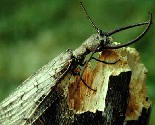
I also saw a Dobson Fly- which is the adult stage of the frightening hellgrammite larvae. This large winged insect with big scary pinchers- was flapping in the water after having fallen in. I scooped him up with the paddle and gave him a ride while he dried off, then deposited him in the grass on the shore.
Not all wildlife interactions were as benevolent. A plague of deer flies seemed to have enveloped the Dolores during my journey and though the DEET I sprayed over myself usually prevented them from biting me, going down a river means ever few dozens or hundreds of feet you are going to encounter a new colony of deer flies that hasn't met you yet and doesn't initially realized you are covered in DEET. So you get like 6 or 8 flying around your head at once and you are trying to swat these guys while making your turns to keep your line and to avoid getting caught up on shallow rocks.
I had also left my food / kitchen bag on the beach night 1 and didn't think much of it. This is pretty normal. But "normally" on commercial trips we have these nice big "dry boxes" that lock up tight and store food efficiently. Here I had a duffel bag that is old and worn and seems to not really close that tightly anymore. Nothing bad seemed to happen with leaving it out though.
Day two for lunch I decided to indulge myself and eat the cookies first- an impossible luxury for a guide to ever experience in normal life. Some of the cookies on top were crumbly so I took a big punch of crumbles and started chewing. Then I looked back into the bag for my next cookie and noticed many of the small, red ANTS.
There were really quite a few of them.
Now I am all about Leave No Trace, picking up microtrash, and yes, faithfully bringing my own ammo can along to poop in. But a mouthful of cookies and ants in most circumstances going to take priority over, well, darn near everything else. Immediately I spit them out into the river and jettisoned the cookies.
After that lunch I went hiking and found what was either old mining stuff or cowboy ruins

* * *
Pulling out into the Colorado you have about 10 miles of still water paddling through deep canyons before entering the 13 mile "daily" section with a few interesting rapids in it.

The river was wide and the current lazy so I ate lunch mid river just getting into the bag and digging out my bagels, peanut butter, jerky, and onions. For dessert I had an orange.
I paddled through here and into the daily section and enjoyed the rapids, which are a lot more fun in a duckie- where they appear larger, and the possibility of flipping is greater than when in a raft.
I camped a little bit below Rocky Rapid at a beach river right in Professor Valley.

A lot of the beauty of this valley sadly is lost in the hustle and bustle of shuttling, rigging, and running Daily trips. When you are just there by yourself and not in a hurry to get anywhere you are finally able to appreciate it the way it is meant to be appreciated. I hiked up into the Chinle formation to examing some interestingly colored rocks and to view the sunset. I got high enough that I could see over the hill and into the green grassy town of Castle Valley across the river. Sunset happened and the rocks started to glow.

I like this picture a lot the cameraphone quality ads a nice touch:

Rocks are pretty cool things to examine.

I forget if this was Chinle, Moenkopi, or Culter, but at any rate this conglomerate is deposited in a sandstone rock layer from Triassic or Permian rock, very very old. How did it get there? I don't think these ones were river rounded like a lot of the ancient stream channels you can detect in the Culter. Geology is pretty mysterious.
In the morning as I ate breakfast on the beach a family of young Geese led by their Goose- mother swam upstream past me.

The next day began with White's rapid, the biggest on this trip. I have had incidents there before.
The first time I ran it fine in a duckie, at about 20,000 cfs with big fun standing waves. The next time was in an inflatable pool toy and I flipped early but it was at even higher water so I just hung on and rode out the much lighter wave train that the rapid becomes when it is washed out. The time after that I ran it flawlessly, also on a pool toy. The time after that I was on a pool toy again and flipped in the hole and went swimming. The time after that I was on a 14 ft paddle boat and the captain (a friend of a friend) and my friend were both drunker than I think anyone has a right to be on a river. He steered us right into the hole, and sitting on the middle of the stern, was ejected. The force of the wave also pushed the other member of the crew overboard. I found myself alone on a 14 foot raft trying to paddle it to two drunks who didn't seem the least bit interested in swimming either to the boat or to shore. Finally one and then the second were rescued. I no longer raft with those people.
This time I skillfully avoided the hole, going just to the left of it, excited to try out the duckie in the standing / lateral waves just beyond. However the owner of this duckie is a bit shorter than me and the paddle I have been using this whole time has been a bit short. Short paddles in duckies are obnoxious because they drip water on you constantly, and they prevent you from turning as fast as you might need to. I came into the lateral a bit pointed too far to the left.
And immediately flipped.
Luckily I had rigged to flip every day and all was tied in well- nothing got lost and nothing got wet that needed to stay dry. I was able to flip the duck and re-board it rapidly before the end of the rapid.
Sometimes when guiding trips my fellow guides may want to dump out the extra water at the end of the trip. I always insist on waiting until we get back to the ranch, "just in case"- we get a flat tire, we stop and get thirsty, we meet people biking their own shuttle who could use some extra water (this has happened), etc... I have never before though run a trip with EXACTLY enough water. For this trip, apparently, I brought EXACTLY enough water along. I had only one liter left 100 yards above the take out. The moral of this story is that you never want exactly enough water... being able to pull over and make coffee or have extra tea at morning is pretty nice. Plus the piece of mind you get...
Luckily for me, 100 yards above the takeout is Matrimony Spring, a source of clean drinkable water spilling out of the Kayenta cliffs along the river just north of Moab that has been a source of dependable drinking water since the earliest days of Mormon Settlement in the valley. I tied the boat off and refilled a few gallons into my large green 7 gallon water jug.
Then I paddled down to the boat ramp. I was two hours early. It was 3pm and about 100 degrees. A hostellian who shall remain nameless had agreed to have his phone on that day and meet me at the ramp at 5pm. I called him and his voice mail was not set up so I left a text. The rafting outfitter I work for sometimes is only about a mile away from the ramp, so I deflated my boat, breaking it all down into three piles, and began carry each pile towards the outfitter, carrying one far, then dropping it down, then going back for the next pile to carry it just beyond the first one, etc... etc...
At 6:37pm after I had stowed my gear and hiked all the way across town and back to the hostel I got a call from this individual informing me his hike with Trundell, the hostel dog, had just ended, and he was now free.
I had survived the rapids and the river and the deer flies, but was I any match for a long walk/ hitch back across the desert, the La Sals, and on to Gateway?
Survive I did, but it is now 9:40 pm and I have got about 3 hours of sleep in the past night of travel. My brain can no longer sustain the timely output of this recollection and my tent is not even set up yet. Stay tuned for The Circumnavigation of the La Sal Mountains, Pt 2!


No comments:
Post a Comment