I saw a picture on Al Jazeera of a tear gas canister. It said "Made in America" on it.
The US government continues its own support for the hated, tottering dictator Mubarak, despite the overwhelming citizen opposition to him
The people of Egypt, who are less impressed than Beltway politicians with the "stability" of the government they've been oppressed by for 30 years, are remaking the country in their own image.
This is more than the collapse of a dictatorship. Hopefully it is the collapse of the myth that the US government- Republican or Democrat- ever cared about "Democracy" in the Middle East. They have always preferred predictable "Strong Men" to the tumult of democracy from below.
Concerned Americans should at least be able to summon the courage to call the White House Switchboard and demand a hault to US support for the Mubarak regime. Their number is 202-456-1414 and the best time to call is between 9 am and 5 pm EST. There are also world wide protests at all Egyptian Embassies. Should there be one near you please do your best to protest / disrupt its operations.
Friday, January 28, 2011
Tuesday, January 25, 2011
Latest Savage Ideal Gets 7/8 on Side-Line
As you probably know, myspace is not really used that much anymore by anyone, and I hadn't checked the Savage Ideal account in a while. Tonight I am sick with a cold, and unable to sleep. I got tired of playing snood and reading long articles. So I logged into the ms for the heck of it to see how it is doing these days.
Low and behold, it seems I had a message here back in December from an actual person! Sideline has completed their review of Ghosts Dance Lightly on the Puncheon Floor and wrote me to let me know about it. You can read it here:
http://www.side-line.com/reviews_comments.php?id=45603_0_17_0_C
We got 7/8!
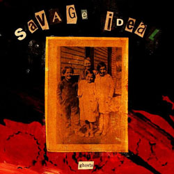
Of course you can buy or download for free the album from Connexion Bizarre.
"Savage Ideal is a project set up by Christian Wright... a fascinating sonic experience where the artist is moving in between the edges of ambient and industrial music. The heavy industrial rhythmic is a rather constant element emerging from the songs. It creates a real outburst of power..."
I had mailed copies of the record out to 5 different magazines that expressed an interest in reviewing it back in July. This is the first review I've got back. But it is a good one.
Low and behold, it seems I had a message here back in December from an actual person! Sideline has completed their review of Ghosts Dance Lightly on the Puncheon Floor and wrote me to let me know about it. You can read it here:
http://www.side-line.com/reviews_comments.php?id=45603_0_17_0_C
We got 7/8!
Of course you can buy or download for free the album from Connexion Bizarre.
"Savage Ideal is a project set up by Christian Wright... a fascinating sonic experience where the artist is moving in between the edges of ambient and industrial music. The heavy industrial rhythmic is a rather constant element emerging from the songs. It creates a real outburst of power..."
I had mailed copies of the record out to 5 different magazines that expressed an interest in reviewing it back in July. This is the first review I've got back. But it is a good one.
Friday, January 21, 2011
Car Insurance
How much do you pay?
Recently my vehicle was destroyed on black ice driving back from my job. That really pissed me off. People kept saying, "Don't worry, you are okay, and that is what is important." And I have been saying, "Are you fucking kidding? Do you know what it is like to buy a new car, and deal with insurance companies, and hitch hike to work until that happens?"
So for a month I've been about 50/50 getting rides from coworkers or hitch hiking to work, which is at a ski resort 32 miles away from my house. Today I am signing on a new vehicle.
I called progressive for a quote. They said $300 a month. I laughed.
I called Geico. Their website gave me a quote of $79, which was pretty sweet. However, when I called them, they raised the rate to $145 a month because I did not have insurance for the one month I was without a car, and because in the eyes of the insurance companies and US Courts the accident was my fault for hitting black ice and crashing. Not the ice's fault. No. The ice was granted complete innocence by the unelected, profit driven bureaucrats at the insurance company. Despite my recollection of the ice playing a principal role in my vehicle's decision to slam into a guard rail at 45 mph, and also irrespective of the fact that for the 99.99999999% of my life I have been driving on roads without any ice on them I have never slammed into a guard rail. I called the police but they didn't feel like sending anyone out to investigate the crash site. They did not interview the ice. They did not provide me with a court of law, jury of my peers, or opportunity to cross examine the ice in front of a judge.
This is what pissed me off so much about the wreck. I knew I'd be sitting here, at 12:47pm on my day off, calling insurance companies on the phone trying to get a deal. I knew I'd be ripped off by them. And I knew that even after I set something up I'd still have to walk two miles and then try to hitch hike to another state to pick the vehicle up.
I am excited about it being a new vehicle. Have never bought a new vehicle before. I went to a few dealers and played some off each other and got a slightly better deal, which I am happy about. Still, that being said, newer cars are more expensive to insure. This will be the last new car I purchase.
My plans for the future including drawing up a waiver I get all passengers to sign that forfeits their right to sue me if we get in a wreck. This is in part due to the fact that to get a better deal on insurance coverage I had to agree to drastically less medical coverage for myself / passengers in the event of a crash.
My other plan involves a utopian scheme to organize all proletarians to pool their wealth, to purchase millions of new cars, to have them sit in garages not being driven for 5-10 years, and then to be "sold" to members of the co-op as "used" vehicles, which will lower the insurance rates on them at the same time the drivers will be able to appreciate their condition.
* * *
What car insurance do you have? How much do you pay?
What kind of coverage do you have?
Are you frustrated with it? Happy with it?
Any tips for negotiating a better rate?
Ever switched companies? How did that go?
Monday, January 10, 2011
The Assassination of Gabrielle Giffords

The FCC's plan of allowing a handful of corporations to monopolize the public airwaves has ironically resulted in the day to day broadcast of lynch mob politics, death threats and incitement to anti-government violence. Once again... as we've seen with the SEC and the EPA, the existence of a regulatory agency is meaningless if the government itself is controlled by industry.
Two articles:
FOX News: The Number 1 Name in Murder Fantasies
Tuscon Rampage Casts Light on Toxic Political Tone
Of course, the Gun Control issue is already being raised. But I think this misses the point completely. The problem here is that of an FCC licensed news organization encouraging its listeners and viewers to act out on their murderous fantasies. This is the thing that needs to be fought and its effects will prove deadly whether or not FOX viewers use guns, pipe bombs, or Ryder trucks full of house hold chemicals. Is this latest shooter really that much more dangerous than Eric Roudolph or Timothy McVeigh?
The irony here is that the biggest proponents of gun control tend to do very little, in the day to day, to stand up for progressive issues and politically confront today's Neo-McCarthyites- the only thing that can balance our political climate. Obama talking about reaching out for "bipartisanship" while FOX commentators are basically calling for the assassination of Democrats will go down in history as an example of what it means to be completely out of touch with political reality.
I will also point out that the people who support banning certain types of weapons within the 50 states often do the most to facilitate their export around the world, often to repressive governments where they've been responsible for thousands of deaths. International arms sales actually declined in the first two years after Hillary left the White House. See my article.
It's not because people have guns that they shoot elected officials. It's because demagogues like Sarah Palin, Rush Limbaugh, Sean Hannity, Glen Beck and their ilk are whipping up violence and hatred among the most paranoid, ignorant, and impressionable people in society. It is there the problem lies and it is there a solution must be found.
Tuesday, January 4, 2011
Desolation Canyon
(had this saved as a draft since November, where it published under. Republishing here as it is the newest entry and should be viewed first).
Author's Introduction
Part One: There's a place called...
An idea
Fellow Travelers
Getting a Permit
Logistics
Chris P
Part Two: Happy Canyon
The Shuttle
Sand Wash
Bear Attacks
Desert Bighorn
A 55 Million Year Old Lake
Oil Shale
Rivers That Make Rock
A One-Armed Veteran
Death of a Pool Toy
Petroglyphs
A Hike Discovers Fresh Springs, Salt Springs, a Corpse
Rock Creek
Gumdrop Falls
Rafters
Forest Fire!
A Ghost Ranch
Swimmer in a Rapid
Part Three: Bonus Canyon
Cretaceous Seas, Coarse Grained Sediments, Coal, and Iguanadon
Coal Creek Ruin
A Mild Scramble
Part Four: Desolation
Takeout Day
Tamarisk, an Interstate, and Green River, Utah
Disaster
The Uinta Basin: Armpit of the Desert
Death of a Lake
Wal Mart
Tall Mysterious Rocks
Escape
Links
* * *

I have been unable to write the story of my favorite river trip of the summer for quite some time because someone who was on the trip with me, Chris P, took a month and a half to send me his pictures. It was only once they were finally developed, scanned, emailed, and downloaded into my possession that I could at long last use them as the basis to write this story.
You will be very quick to notice this story does not begin at a put in or end at a take out. It encompasses my learning about the existence of Deso, my planning for it, running the canyon, taking out and returning to "civilization", with of course the last quarter of the story entirely devoted to the quest to replace my tire that was destroyed late at night while driving the shuttle. In addition to numerous trip photographs, discussions of meals, campsites, side hikes, and various tidbits of entertaining dialogue, you will find numerous explanations of much historic, geologic, social and economic phenomena that anyone doing this trip is going to encounter- whether they recognize it or not. My ability to write a story of this length is largely due to the fact that for two and half months I have unemployed, between seasonal jobs, and living in my car in Durango, Coloardo. Thus I had plenty of free time to devote myself to writing, and I was quick to catch on to the fact that the interiors of Durango Joes' coffee shops are a lot warmer that the interior of my car. Especially at night.
I had many questions about this trip that I wanted to solve for myself through research, which writing this gave me the opportunity to conduct. Furthermore, in producing this I have been able to effectively procrastinate from my Ghost Town book for three solid months now.
It is my hope that the approach I have taken will answer a lot of questions you might have about running "Deso" before you plan a trip of your own. I also hope that this article could become a resource for anyone who, in an amateur or professional capacity, finds herself drawn to this part of the world and developing an interest in being able to explain a bit more about what is going on here. It is in everyone's interest that Utah river guides, when asked how the rocks got here, be able to avoid one sentence dismissive "explanations", like, "The rocks are interfingered Wasatch and Green River Formation that was deposited in an ancient lake 50 million years ago." Such phrases are all too commonly encountered by those paying someone to take them down a river and what they don't explain is always infinitely greater than what they do.
I've also tried to keep this article accessible to those who are unfamiliar with the routines of river runners, the geography of Eastern Utah, or the culture of seasonal workers in the desert. I've taken steps to avoid jargon where I can, and I've tried to explain it where it is necessary.
If you find any of this story helpful, if you find some of it inaccurate, or if you are just another seasonally homeless person killing time by hanging on in coffee shops surfing the internet, I'd appreciate any comments being left at the bottom. My generation is no longer paid to write. But peer review and mutual encouragement might keep us going yet.
-LF Dec 17, 2010
Part One: There's a place called...
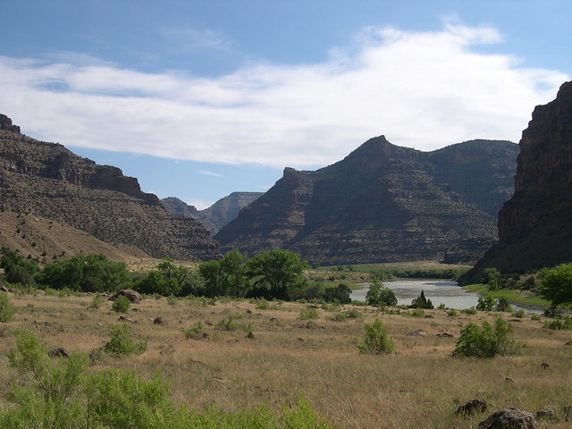
The existence of a place in the West actually named Desolation Canyon was first brought to my attention in the fall of 2009. The previous summer had been my introduction to river guiding as a marginally compensated "trainee". The season had not been long gone before I was online reading about the Green River, whose Labyrinth Canyon I had had the chance to navigate, twice. In my searching I came across someone's online story about how they had done something called Desolation Canyon of the Green River. It was just upstream of the section I had run, and was even more remote country. And there were bigger rapids. Which is to say there even were rapids. This person I found myself reading about had done their trip in rafts because the rapids would have swamped canoes. I then looked online for pictures. "Deso" seemed to have been appropriately named, the photos that came up appeared barren and foreboding. Reading further, I found this stretch was longer than Labyrinth (84 verses 60 river miles), and at one point it was even deeper (5,500 ft) than the Grand Canyon.
And it was called Desolation Canyon!
I decided I would find a way to do this trip. As of May I still had no boat and no solution to the shuttle issue, but that didn't prevent me from picking up the Belknap Deso guide at Down River Equipment on my last trip for supplies there before moving away from Denver.
If you want to do this trip for 5 to 6 days you are going to be spending about $1,000 per person, before tip, (give or take) to do it with a commercial outfitter. If you are going to do this trip solo you are going to need your own boat and you are going to have to pay someone to drive someone else to Sand Wash, pick up you car, and drive both vehicles to the takeout. You will be paying for their gas and time to do this as well, with the standard going rate at the time of this writing being around $200 per vehicle.
A perk of guiding is that I am allowed to borrow inflatable kayaks ("duckies") from an outfitter I work for on occasion. I am also able to borrow a pump, patch kit, fire pan, and a few cam straps from this outfitter. And a paddle. And a spare paddle. These are really welcome perks. I mean, getting paid would be nice too, but being able to borrow river stuff! Now, that is my kind of business.
With boats secured, it was time to start making plans. When could I do it? It would have to be in the early fall, after the guiding season had winded down. And I would need to find some worthy fellow travelers to do it with. Partly because it's cheaper when we all pitch in for gas, shuttles, and permits together, and also because it might actually be nice to have someone to share the canyon with, maybe even to rescue me if I hurt myself.
Earlier in the summer, I had facebook chatted with Tyson from Denver and I had convinced him that he should come out here and go down a river sometime. Tyson is the guy I met on the Colorado Trail who later helped me get a job where I was a street sweeper and a pressure washer and where I got to go to the minor emergency clinic for four shots and a few stitches on my birthday when I cut my head on the dump truck I was driving. Surely, I owed him a little bit of "Desolation" in return.
Before I started working for the outfitter that lets me borrow duckies I was already working for an outfitter that would let me borrow canoes. Able to make use of them we planned for a trip down Labyrinth Canyon. Another friend of mine from Minneapolis had also expressed interest in coming to visit and doing a river trip, so we planned for two cones and three people. However, when I found I had someone to borrow duckies from (and not just any duckies, but good duckies!) I convinced Tyson to move the trip to Deso instead. He could get a whole week off from work which would give us enough time for the trip and for the shuttle. He was a little nervous about the rapids but I figured he could learn how to deal with them easily enough (I was proved right!).
It's a lucky thing that we moved the trip. On August 19th, an apocalyptic rainstorm bombarded the Canyonlands area. I was doing a trip on the Colorado River that very day and the storm was producing large flash floods and water falls off the cliffs:

Among the many flash floods produced, one particularly remarkable one occurred at a place called Mineral Bottom. Mineral Bottom is the takeout for Labyrinth Canyon. The road there was blasted out of solid rock by a Uranium mining company in the 1950s. This storm destroyed the Mineral Bottom Road, stranding cars and boaters at the takeout, 7 of whom had to be airlifted out by helicopter. As of this writing Labyrinth Canyon is not being run by anyone who is not also planning to run the next hundred plus miles of subsequent Stillwater and Cataract Canyons. The only other alternative also involves running the next fifty miles of Stillwater canyon, but then paying $100 per person to be JetBoated back up the Colorado River from the Confluence with the Green fifty miles to Moab. Either way, it's a hundred miles to the next takeout, and you're looking at class IV-V rapids or paying someone money either way you go.
Once Tyson gave me his dates, and I had convinced him to move the trip to Deso, I started looking online for a Permit. The BLM site lists what days permits are available. You check for days you want, and then you call the Price, Utah BLM office to reserve them. They take your credit card over the phone and send you the permit in the mail.
There's a sentence on the BLM site that says "Reservations are made 5 months in advance to aid in trip planning. " Don't let that make you nervous. It is convenient for the BLM schedulers for you to make a reservation 5 months in advance, but it is perfectly acceptable for you to call them up in the middle of July about a permit in September and get it. If you then call them in mid September to add an extra person onto your trip that is leaving a week later they can email you the new permit instead of snail-mailing it so you won't have to worry about it not being there in time.
The only trouble with this system is that the Price BLM is apparently very understaffed and it is rare that they answer their phone when anyone calls it. They also do not return voicemails. So you have to keep calling, day after day, between the hours of 8 am and noon, Monday through Friday, hoping that eventually you'll get lucky and a human will be there to answer the phone.
Finally, I got in touch with them. They were very informative and helpful, and were able to answer a lot of my questions. I bought the permit.
Over the summer I started drawing up a logistics plan for the trip. Not knowing where any campsites were, I just looked at the map for sandbars and planned a trip for 8 days in about 12 mile increments. A little more or less paddling is easy enough to make up, or squander, the next day.
After that there was the matter of planning food for three people for 8 days. This was a little harder. How long would the ice last? How much propane would we take and how long would that last? At what point do we need the cooler empty so we can put fire ashes into the cooler when we start cooking on fires because we have run out of propane?
I've never done a river trip longer than five days before.
By the time I was doing the actual food shopping I had a pretty intense shopping list, budgeted down to specific quantities of ingredients. The City Market in Fruita had plenty of good food, though like most City Markets, they didn't have the best deals. I probably should have gone to the Wal Mart in Grand Junction instead.
When all was said and done, the cost of this trip was $125 per person. If you included the cost of everyone's gasoline to drive from Denver or Moab it was more like $175-200 per person. That is a pretty good deal. A lot of people can't even keep themselves alive in a city for a week for that little.
The only remaining loose end was just the small matter of my friend from Minneapolis deciding not to return any calls or emails as our launch date got closer and closer. Correctly assuming that they were flaking out, I asked Chris P, of the Moab Hostel and The Dark Crow, if he'd like to come. He said yes. He got excited. I got excited. It was about as axiomatic for him to go down something called Desolation Canyon as it was for me to join and captain his Viking- themed cardboard boat crew to victory in two races in Moab. We made a pretty good team then, and having done Ken's Lake and the Moab Daily section of the Colorado River together several times over the summer in inflatable pool toys and cardboard boats, I felt he was definitely ready to take on an entire 84 mile long canyon. Just look at this guy.
How would you NOT want him on your river trip?

The last bit of planning involved the gnawing unpredictability of exactly what kind of weather we would be facing. It is one thing to find yourself cold and wet on a camping trip you have planned for yourself. It is quiet another to have your own optimistic assurances be the reason why other people are cold and wet. On that day in sunny July when I bought the permit the ranger had assured me that by late September- October, we could get away without wetsuits in Deso. That sounded good at the time. But it didn't stop me from being nervous two months later, sitting in the coffee shop in Grand Junction.
I recently done my first trip through Westwater, a narrow, dark canyon of the Colorado River, where the wind and the shade and the water temperature- no longer steadily rising but now falling- first told me that Summer was ending and the Fall was coming on. On that trip I put on my splash jacket after the first few minor rapids. Unlike all previous trips that summer, where I'd often jump out of a boat for the heck of it to swim around a little bit, on that trip I was actually worried about falling out into the cold, cold water. It was my memory of this trip, and the knowledge that on Deso I'd be taking two friends along, who if they died, I would have to deal with, that prompted me to use my NRS account to put in an order. Besides a new headlamp and a few more cam straps I could use, I ordered the rescue model wetsuit. It's the thickest one NRS sells. Just before Deso, I took it to the lake in Fruita to test it out. It was great. With that and the other wetsuit my river friend Martin had offered to loan me, I felt that if the worst came to the worst, I could put the two friends in Wetsuits, and I'd be okay with a splash jacket and a few layers of wool and poly on my legs.
After all the careful logisticizing, my thoughts eventually drifted over toward wondering at what point the plans would start to go wrong.
No trip leader can avoid thinking about these worst case scenarios, after having done all they can to prepare, but still knowing that they cannot predict everything in advance. Would the weather sour? Would someone get hypothermic? Would someone flip in a rapid and have tied gear down wrong and in that case, what would we loose? Would it be the food? Or the fire pan? Would Tyson figure out the rapids or would he flip and drown? Would we get eaten by bears? Just how "desolate" would we be, marooned on some rock, with no cell phone reception and an evacuation to plan?
Turns out the trip would be for the most part fine, with our only problems cropping up in the form of a flat while running the shuttle the night after the trip was finished. That first picture of me replacing the tire, after traveling 150 miles to buy a new one, will be my enduring memory of the most desolation I have seen all summer. For sure, more desolate than the great salt flats where the skin and throats of California emigrants were burned by alkali dust and unrelenting sun. More desolate than the vertical shafts and mining ruins of Death Canyon. More desolate than the Fish Springs Range. More desolate than El Diente Peak where two people were killed by rocks this summer after I had climbed it without being killed by rocks. More desolate than my sideways run through the right hole in Big Drops Three on the BLESMA trip in Cataract Canyon, or even my recovery and unintended run over Little Niagara in Big Drops Two. More desolate than the Moab Hostel after a certain unnamed resident freaked out and beat up Nicholas and everyone got sketched out and left except for the two creepy unemployed old guys who play chess all day and watch bad TV. More desolate than even backing into the wash in the Dixie National Forest, which I assure you sucked horribly, but had the fortune to occur in a region of ready help capable of fixing the problem on the spot. My Desolation would be the Desolation of the car, in the Uinta Basin, with a flat tire, on a Sunday, about as far away and on bad dirt roads as it is possible to get from a tire repair shop in the lower 48.
The trip started so innocent.
Part Two: Happy Canyon
Wrinkles Road I had heard was the worst damn back road in the state of Utah for flat tires. Infamous to many who run rivers, the road winds its way across a Tavaputs Mesa of Green River Shale to its final, menacing five mile section down Salt Wash- not just a name for a place- but an actual Wash that you drive down. The Wash is graded. But that both hurts as well as helps. A hard, flat, smooth graded road is an easy place for a razor sharp tooth of shale to get stuck in your tire, nowhere to go for it to fall or crumble or be pushed out of the way.
"The issue with the Sand Wash road is that you can drive 5, 15 or 25 mph but if you drive over the shale, a rock can kick up and slice the tire. "
I had heard horror stories.
Just before leaving to explore the Ghost Towns ( 1, 2 ), I was amid some beer drinking festivities at Arland and Chris' house in Moab. They have this kind of friendly drunken farmer for a neighbor who laughs a lot when you say funny things around him. Or anything around him. That evening Chris and I were throughly educated as to this guy's opinion of the Sand Wash Road, as it existed years ago when he last did Deso. Driving there in a truck, the road was for him no problem. That made me feel a little bit better but I was still of course not willing to trust this guy's opinion.
Time passed. I rushed through my ghost towns. It was time to start getting ready.
I finished assembling gear the day before we were to meet up. I spent a few hours at the sheds , making sure we got equipment in good condition, boats with few scratches and intact carrying handles, enough cam straps, a patch kit... I put everything into piles on the pavement before loading it into the vehicle and double checked the permit one last time to make sure I didn't forget anything.
The next morning in Fruita I did the shopping and was hanging out in the parking lot repackaging everything when Tyson showed up. A few minutes later, we had consolidated our cooking gear into just what we'd need for the trip. Once it and the food were thrown in dry bags, we were on our way to Green River to meet Chris and drop cars off at the takeout, Swaseys' Rapid. We got there about 50 minutes late. But we didn't wind up needing anything on the river itself that I hadn't thought to pack (or have Chris or Tyson bring), with the possible exception of a grappling hook that would have been convenient. In my book a record like that on a private trip is an acceptable enough reason to be late.
At Swaseys' we got into Chris' truck, which is a 2005 Chevy Colorado with a cab and a nice topper. I folded myself up into the cab for the first leg of the journey, North on Highway 6/191 to Wellington.

This incredibly scenic stretch of state highway is bordered on the right by steeply eroded "Book Cliffs" of stream deposited Cretaceous sandstone. On the left is the San Rafael "Reef" of petrified sand dunes dating from the Jurassic. Sandwiched between the two in space as well as time is a highway paved over Mancos Shale, once the bed of an ancient sea, now uplifted to 4,500 feet and containing abundant clam fossils. The Good Lord, indeed, must have been as busy as he was indecisive on that Third Day.
At Welligton, I switched places with Tyson to help navigate. We headed into the cliffs, past a coal mine, and towards Nine Mile Canyon.
The road was well marked, and we had no problems finding our way or getting lost. I knew before the trip that Nine Mile Canyon is famous for its petroglyphs, but being so focused on just making the trip possible I didn't study up on "interp" as much as I would have if this was a commercial trip. Nonetheless, we saw a few examples of the Ute and Fremont cliff etchings along the way, and we stopped, pondered, and examined.
We got to the put in just as evening was coming on and our desire to explore was tempered by a need to slip into something more insulated than T shirts. We walked around, checked out the place, and discovered the ranger was out for a hike and that we wouldn't be able to check in with him until tomorrow. This we learned from another group of friendly river runners that we'd be running into off and on throughout the trip. We admired an old historic cabin, and some newer bug screened huts* we hadn't reserved before settling on the number 2 campsite, behind the shitters.

You can't smell the shitters in this photo, but they are there, just out of the frame off to the left. And I tell you there is no smell of desert river running in Utah quite like the smell of a BLM shitter. This campsite didn't smell as bad as the other one, but...
There at least were no bugs! Nor commercial launches, nor threats of heat stroke. I must say, this end of September is really a great time to run rivers. Water is down, no bugs, no crowds, things are nice...
Chris P made us one of his trademark steak dinners that night. We also took a moment, er, rather... a few moments, to assess and confirm the quality of our liquor supply. As we were doing this trip with smaller craft, space was at a premium. We settled for more concentrated stuff as opposed to beer. We had a nalgene of Sky Vodka, a nalgene of unidentified Rum, a handle of Ancient Age Bourbon, and a handle of Sauza Blanco tequila. Feeling the cool air and looking at our warm drink provisions, we settled on the cocktail whose potential would be thoroughly explored and exploited over the next 8 nights: hot chocolate with booze.
Chris is a Park Ranger Academy graduate. He likes camp fires and he likes them big. For most of the trip we had to have smaller ones as our fire pan is a thing of finite proportions, and because we were packing out the ashes in accordance with leave no trace ethics (as well as BLM regulations). But this first night he had a large fixed campfire ring to work with, and he was in his element, with characteristic armbound headlamp, making a large cooking fire.

We had many potatoes, so we fried them up as a side to the steak with oil, salt, and rosemary, in Tyson's lovely cast iron pan that cost $40.

That pan is what we took to cook with, and it would over the next 7 days become something of a source of tension within our group. Chris P, who was a former fancy chef, and myself who is a former fancy waiter as well as professional river chef, made clear on several occasions our desire to wash the pan, so that it would not emit a bear attracting smell while we slept. We offered to re-season it immediately after we washed it so it would not rust. Tyson, however, was adamant in his refusal to let this happen. The pan was clearly his piece of equipment, which he was going to take care of, and until he drowned in a rapid or was eaten by a bear himself, there was going to be nothing we could do about that.
Here are a few links to stories about bear attacks late season (when bears are hungry and stocking up on fat for the winter) in Desolation Canyon:

http://www.deseretnews.com/article/705336739/Desolation-Canyon-bear-attacks-may-be-linked-to-drought.html
http://www.deseretnews.com/article/995595/Bear-attack-prompts-warning.html
http://www.ksl.com/?nid=148&sid=7717153
http://www.blm.gov/ut/st/en/fo/price/recreation/riverinf/bears.html
Coming to grips with this state of affairs I decided to allow Chris and Tyson to pitch their tents each evening where ever they liked. I then just slept on my thermarest or in my duckie just a few feet from the river, with the bear spray out and next to me. Thataway, a bear would first smell and have to eat through either Chris or Tyson before it got to me, and I'd likely be awakened by their screams in time to act heroically or run away, depending of course on the situation.
Fortunately, no bears were seen or felt by our group on this trip.
Though I still think he should have let us wash that pan.
This is what it looks like where Sand Wash empties into the Green River, constricting the channel, though it is still wide enough and the gradient is still gentle enough so as not to cause a rapid:

A "wash" is like a gully or ravine. It is usually dry. But on those rare occasions when it rains in the desert, washes, often draining a large area, can fill up quickly and become raging torrents, eroding their banks, carving deep gullies, and pushing large boulders over one another along their bottoms, the sound of which you can hear should you ever be "lucky" enough to witness a wash in flash flood.
Washes can be extremely dangerous. They can eat roads. This is what my car looked like when it fell into a wash that was eating a road in the Dixie National Forest. It took myself, an old man, three rednecks, two tow trucks, a pickup trick, a z drag, $250 and a whole day to get that thing out of there.
Luckily, it didn't rain and our time at Sand Wash was rather peaceful.
Here we are on Day One, Sept 26th, unloading the truck and pumping up the duckies:

Loading the duckies:

Notice the sunshine. It would be sunny for our entire trip, the day before, and the day after. Three days before the trip, a torrential downpour (1, 2, 3) caused flooding throughout the area. The night our shuttle was completed, the rains returned again. We were very lucky!
Things get tied in with cam straps, which are a great invention. It's important to be able to start with a lot of them, though as days go by and you repack each morning, you learn how to become more efficient and you tend to acquire extra straps, which you can then use for bow and stern lines.
As we set off paddling Chris P announced that he had brought along the lawn chair. If only I had known! I would have brought along the Dirty Dog! The lawn chair (with cupholder!) and the Dirty Dog are both $11 inflatable pool toys we bought at Walker Drug in Moab. I did the "Moab Daily" in the dog three times (once at 20,000 cfs and once at peak snowmelt of 30,000!) and Chris did it in the lawn chair at least twice. Well, the lawn chair is a more relaxing ride anyway, and after fixing a leak with duct tape I paddled it for a while. As days one and two were basically still water, we took these with no hurry, enjoying the relaxation of finally being on the water.

We passed "Little Horse Bottom" and saw wild horses who had come down to drink the river. They actually looked a lot like Mark Peesel's picture of a wild horse that's in the guidebook. About this time we passed through our first named bit of aquatic turbulence: "Tabyago Rifle." There were no casualties.
Chris on his vessel

I make my dry bag into a pretty comfortable back rest

The walls began rising pretty steep pretty fast, with deep alcoves and "amphitheaters" carved by erosion.

Late in the afternoon we found a small sandbar and camped out on it.

One of the many advantages of doing light, self supported duckie trips (still far more luxurious than backpacking) is that with a small group like ours you can camp pretty much anywhere. This came in very handy for us, as in the planning stage I had opted not to spend the extra $30 to be able to camp (or set foot) on the left side of the river- which is part of the Ute Reservation and which has a separate usage fee in addition to the already mandatory BLM fee. That afternoon we passed at least one marvelous looking sandbar river left- the first of many such great looking campsites we would pass and not camp on. When I do this trip again I am definitely picking up the Ute permit. Being able to pull over at the next best place is a pretty nice convenience to have when you are tired from a long day of paddling and the sun is going down over the rim and temperatures are starting to drop.
That evening we had steak and couscous.

The next day was more still water, with a few riffles, and two or three rather unintimidating rapids. Deso isn't just a great trip because it of its name, or because of its remoteness, or because of its rapids... but the whole canyon from Sand Wash to Green River couldn't have been built better if you were trying to design a place to teach someone white water river running. This is what Bill Belknap- the guy who wrote several popular waterproof guide books- used to do professionally. He founded a company called Fastwater Expeditions that took people who hadn't been in rivers before down Deso in "sport yaks"- 7 foot plastic dinghies rowed with oars. You start with two days of riffles to get used to the wilderness, and to learn to maneuver your craft amid faster moving water. Then on day three you're hit with a few actual rapids. They eventually grow in size until you're ready to run Three Fords, about the "biggest" rapid at this water level.
The University of Northern Arizona has a fascinating online exhibit on the life and photographs of Bill Belknap. Few boaters using his guides today probably know one of Bills first jobs was as a publicist for Boulder Dam, that he accompanied Roosevelt to Potsdam as a photographer, or that his highest level of completed education was the 8th grade.
None of the rapids in Desolation Canyon posed any great technical challenges. A few rapids had rocks to dodge in them, but this was fairly easy to do. Cow Swim was probably the "hardest" in that you had to turn to the right mid way through the rapid so as not to hit the steeply cut wall river left, but even this was pretty easy. Square up to waves and holes, avoid the rocks, and follow the "tongue" on everything and you'll be fine in Desolation Canyon.
By no means, though, should you interpret this to be me saying that the rapids are not exciting. For in several: Lower Wildhorse, Chandler Falls, Surprise Rapid, Cow Swim, Three Fords, and Coal Creek, to name but a few, you get some bounce!
The morning of this second day we slept in pretty late, and in doing so set for ourselves a comfortable pattern for the rest of the trip. In the morning we'd be passed by groups of early risers while we ate breakfast. Eventually we'd catch up and pass these groups- often already at their campsites- later in the afternoon. With the folks we met at Sand Wash we wound up frequently stopping to trade some liquor for a few river beers to finish our day on the river.
I definitely appreciated finally being able to sleep in late, and to not have to set my alarm for 5:30 am to wake up in the cold, pack all my gear, and rush to make breakfast for 25 people!
After breakfast on "morning" 2, in a bit of calm, deep water just off our sandbar, we conducted our first flip drills. I wanted to be sure everyone could manage to get back on top of their over turned boat, flip it back over, and then get back in, before we got into any of the bigger class three rapids. Tyson and Chris got the hang of this pretty quick, and even figured out some ways of using their knees to flip the boats back over that seemed to work a little faster than what I was doing.
We continued down the canyon.
Suddenly, river right and downstream, we spotted a herd of Desert Bighorn Sheep. Desert Bighorn are a lot like the regular Rocky Mountain Bighorn, but they have adapted to a harsher environment and can go longer without water. Tyson got his camera out and maneuvered his craft so as to glide right by the sheep. In time he was closer and closer and had still not taken his picture. We were basically shouting at him by this point to take the damn picture already before the sheep got scared and ran away, and he continued to hesitate. Finally, he got some great shots, very up close. The sheep finally wandered a bit, but hardly "ran".

We ate lunch while floating this second day, an innovation we would continue throughout the trip. In an easily accessible "rocket box" were bagels, peanut butter, pretzels, chocolate rations, gold fish crackers, tangerines, oranges, and pringles. These were kept upright and accessible with only having to remove one cam strap to get the lid off.
Shortly after lunch, while I was standing on my boat and looking down stream, it occurred to Chris that a bit of a laugh could be had at my expense by stealthily paddling his vessel up to mine and then at the last minute using his paddle as a ram to push me off. Before I knew what had happened I was toppling into the silty, foreboding embrace of the Green River.
Though I was a good sport about this it would be inaccurate to say that I held no grudges. The sun had gone down and it was a little late in the day to be soaked.
Downstream was a little bar. What was it like? I got out and approached

Mud.
Yes. Mud. Just a few inches of mud.
Wait.
On the downstream end of the sandbar actual sand is deposited over the mud, and the whole bar is about a foot above river level, with just enough space for our kitchen and a few tents. We made camp.

You can see in this picture how the geology is already changing. When we started the canyon walls were gray. Here they are mostly brown. On an aesthetic level I appreciated the beauty but on a geologic level I was perplexed.
I knew there were two types of rocks in the canyon.The Green River Formation and the Wasatch Formation. But which was which? I knew from stratigraphy I had studied that the Wasatch Formation was older (deposited first) than the Green River Formation. But I had also heard that the two formations are "interfingered". If you look back to the photo of our campsite on night one, you can clearly see two interfingered formations. The gray formation from the first day was dominant, but by now it has clearly given way. The walls are now generally brown-orange sandstone, though I can still see thin gray seams of another formation (gray shale and mudstone) horizontally deposited between different brown-orange layers.

What is going on here?
The Belknap guides can be handy in a pinch, but they have their limitations. For example, on day one we admired the interesting picture of the historic "iron prowed skiff" the guide said was below "Gold Hole." However, the guide then lists two different places called "Gold Hole" (between miles 89-88, and again between miles 82-81). So which was the skiff beneath? Needless to say, we never found it.
The geology section in the back of the Belknap guide is pretty helpful, but it and the trip left me with more questions than answers. I would have to do more research, and I have taken the time to do this in the hopes that someone reading the article will leave it being less confused about geology than I have been after reading most Desolation Canyon trip reports.
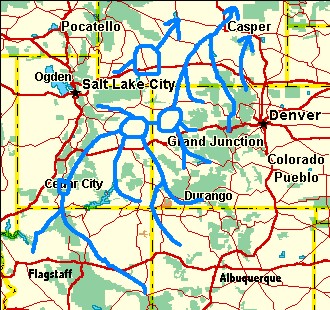
The story begins about 55-44 million years ago, in the period of geologic history referred to as the Eocene, when Utah looked very different. Where today there are the high and dry wastes of the Uinta Basin, there was once a great lake: Lake Green River. This lake's history has been recorded in several different geologic formations. The exact borders and boundaries of this lake are difficult to pin down for sure because so much of the southern boundary has been eroded away. But, we can tell that this lake extended over the Uinta Basin, and around the Uinta Mountains into Northwest Colorado and South West Wyoming. It would have looked something like this:

The black line on the map above represents the present-day location of Desolation Canyon.
The Wyoming section of this ancient lake is referred to as "Lake Gosiute." The Uinta Basin part of this lake is referred to as "Lake Uinta." It is unclear whether these lakes were one giant lake or were separated by land, connected perhaps only by streams. What is important, however, is that where these lakes once stood there is now over 4,000 feet of rock- a fossiliferous, carbon rich depositional record of life.
In the days of Lake Uinta, Utah was a much warmer place. As I am writing these words the temperature this week in Desolation Canyon will be 20 degrees at night and snowing. But 50 million years ago the climate was warm enough to support the existence of crocodiles, whose fossils are found in the Green River Formation, Lake Uinta's ancient lake bottom. The higher temperatures appreciated by the crocodiles were a condition of the earth's actual climate at the time, and not because of a more southerly location of the North American Plate, for the plate then was not at a much different latitude than it is at today.
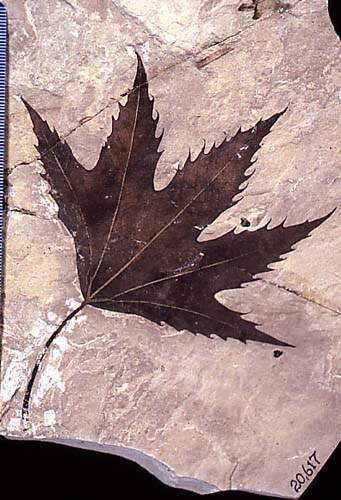
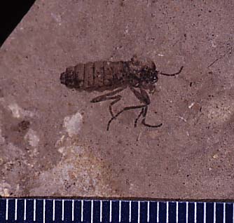
The crocodiles were not alone, for the fish they preyed on are also well preserved and their fossils have been known to science since the 1840s. The grains of sediment in the lake bed were so fine that they were even able to preserve leaves and insects. A trip to the Utah Field House of Natural History State Park / Museum in Vernal will reward the historically curious with a very large collection of these specimens.
A few examples:


It is thought that the lake must have been very deep and stagnant, with low oxygen levels near its bottom which kept scavengers away and allowed the fossils to form.
Green River Shale has also been in the news because of its rich energy deposits. Lots of oil is found in the shale, and is drilled for enthusiastically through the Unita Basin. Oil shale as well has been found in the Green River Formation in tremendous quantities. On any river trip along the Colorado River it is common to find pieces of this shale that has been carried down by erosion. It appears flat and white, river-rounded into thick "pancakes." You can break it open to expose the black interior and immediately the smell of oil is released. You can even light this rock on fire, a fact that must have been discovered for the first time by a very unfortunate homesteader, stoking up a warm fire in a chimney he built of this flat, convenient rock for his log cabin.

No one knows for sure how much oil shale there actually is but it is estimated that there is about 213 billion tons of the rock spread across the borders of Utah, Colorado, and Wyoming. These deposits represent about one half of global oil shale reserves. The Uinta Basin is estimated by the USGS to contain about 1.3 trillion barrels of oil-like kerogen, with another 1.5 trillion barrels are estimated to be in even higher quality ore in Colorado's neighboring Piceance Basin. Currently our country consumes about 20 million barrels per day of oil, and the satisfaction of this demand has hitherto plunged us into all kinds of unpleasant and expensive relations with foreign countries. So, you might ask, why not mine the stuff, and achieve "energy independence" for the next few hundred years?
There are currently several experimental sites oil companies have leased from the BLM on the Roan Plateau in Colorado where they are attempting to devise ways to economically extract liquid oil from oil shale. There are many reasons why this is a difficult process. Methods currently being experimented with require the underground application of intense heat to the shale- a very energy and water-intensive process that itself consumes much of the energy you are trying to extract in the first place. So far it is cheaper to buy pumped liquid oil than it is to do this.
Let's say cost was not an issue, and we were so desperate to get out of the Middle East that ultra- nationalists were voted into office with a mandate to subsidize oil shale development. To do this with present technology would take enormous quantities of water in an area where water is scarce. And there would still be serious concerns about air and water pollution that could effect everyone dependent on the Colorado River as a drinking source.

For now much of the oil shale is classified as a "strategic reserve" that no one really knows what to do with.
Talking about so much rock having been transformed into oil shale, and so much more of the Green River formation that is not oil shale but ordinary shale and mudstone, you might be wondering, where did all the mountains of sediment come from that filled in this lake? That question is the key to understanding Lake Uinta and the Wasatch- Green River "interfingering".
Of course some of the sediments that filled this lake were carried there from the southern slopes of the Uinta Mountains. But the Uintas alone did not supply all the sediment. To understand where all of it came from, you have to understand that during this time, the ancient river systems of the Colorado Plateau drained to the north, in an opposite direction to the way they flow today. This condition continued until only about 25 million years ago, when uplifts in Colorado and Wyoming changed river patterns.
The land around the lake was very, very flat. This allowed lake levels in high water years to expand across great geographic distances very quickly, rolling over the various sandy deltas of stream deposited sediment and then burying them beneath the fine grained muck and ooze of stagnant lake bottom- dirt, mud, dead aquatic animals, plankton, decomposing leaves and plants. Soon enough these lacustrine (lake-deposited) sediments would be buried beneath the sands carried by North- flowing tributaries. The lake level could for a time retreat, though only for a while before the process repeated itself.
A great way to appreciate just how much sediment was flowing to the north is to take a trip down Cataract Canyon of the Colorado River. The lower half of Cataract has been flooded by Lake Powell, whose waters conceal the former locations of over half the canyon's rapids. On the last day of your trip, you are basically paddling (or motoring) through Lake Powell. But on each side of you you do not see just a rock canyon. No. You see high walls of sand, the "Powell Formation"- sediment that was carried by the river and deposited here at the mouth of the lake during its high water years. Here is a picture from a trip in August of these sediments opposite our campsite just below the rapids:

To appreciate the scale, and the varieties in thickness different flows and sediment loads in different years can carry, here is the present author examining this "formation" and providing himself a human figure to scale:

All that sand was laid down in less than two decades. It extends for miles on both sides of the river as well as under it and far into lake Powell. And that is only sand from the Colorado's upper basin- the Green, the Yampa, the Gunnison, Dolores, and the Colorado itself. Lake Uinta was the recipient of this sand for millions of years, and not just from these ancestral rivers- for the ancient San Juan and Little Colorado drainages were at this time flowing to the North as well!
The Colton Member of the Wastach Formation is the name given to the sandstone deposits ancient streams once carried Northward into Lake Uintah. It is this formation that you see thin, red-orange layers of at the end of your first day. It is this formation that comes to dominate the canyon as you get deeper into it. You're passing through an ancient river delta.
Finally, in early Miocene time, about 23 million years ago, the Tavaputs Plateau was just beginning its uplift. The Yampa river was then still a powerful tributary flowing from East to West into the silted up former lake. It began cutting desolation canyon to the South. The fact that Desolation Canyon can exist at all is because the river cut downward faster than the rock it was cutting was rising. About this time, the Wind River Mountains in Wyoming began to uplift again causing the Green River to turn South and join the Yampa.
Though we commonly refer to the Yampa as a tributary of the Green, if you examine these rivers as they were formed historically, the Yampa was there first, and the Green is really a tributary of it!
* * *
That second night, while wondering and not knowing exactly what was going on with the changing rocks around us, we dined upon soup with a side of bagel, as we would for several nights to come. The cool nights of late season are wonderful for soup.

Bagels are always a nice compliment, and they fill you up in a way that helps to stretch a limited quantity of soup into seconds and thirds for hungry paddlers.
After dinner we baited lines with bits of meat, and later, fish innards, in an attempt to catch the elusive and alleged Green River Alpha Cat

Unfortunately, though we did catch many catfish, they were all small, a foot long or less. Hardly worth the effort for a meal to deal with such a slippery, spiny creature. We knew, surely, that true Alpha Cats must exist somewhere down there. But catching them was another matter. Though we had brought plenty of cooking oil, and even a fish basket in anticipation of having a fish dinner one night, this was never to be.
In less than an hour we had abandoned the futility of our fishing luck and opted to retire to our own respective liquors. We admired the stars and searched in vain for constellations we could identify within that tiny sliver of sky we could see between the canyon walls. The summer stars were turning, the winter ones were not yet out. From time to time we consulted the star chart, before finally deciding the stars looked good no matter what they are called. We sat back and conversed, drifted to politics, social issues, families, and back again. From the trivial to the serious. Big issue conversations on the river are curious things. The environment is relaxed enough, and the presence of bears and rapids and other forms of potential death is able to instill a sense of comradery deep enough, that even representatives of a culture as adverse to meaningful political conversation as ours find themselves asking questions and stating views with a frankness rarely present in more "civilized" environments. With all their distractions. But here... with these canyon walls and sandstone rocks, a flood plain that 50 million years ago was formed from other eroded sandstones that themselves had already been laid down long before the Dinosaurs. Nature silently listened, in stoic wonder, as three young members of this new, stumbling species struggle to define the "proper" way to legislate their own emotional and reproductive exuberance... while vacationing paleontologists fail to applaud, condemn, or even notice the sexual preferences of those ungainly, early mammals whose entire species' cultural development had been reduced to a few disorganized bones sticking out of a crumbling rock wall twenty million years before the fist monkey walked upright...
I participate, fully, in the ensuing discussion. Not so annoyed to be reminded of "politics" this far from organized humanity as I am invigorated by my surroundings.
"As much as I love listening to this... I need to tell you that my mother is a lesbian, and she raised me herself. She was an active parent in our Boy Scouts and when she came out they kicked us out. Are you saying you there is something wrong with me because I was raised by a gay parent?"
* * *
The next morning we were treated to a fantastic view of what Desolation has to offer. This picture was taken from our sandbar just upstream from Lighthouse Rock, which is the distant phallic object river right. The red cliffs are the dominant (Colton Member of the) Wasatch Formation, the seams of Green River Formation are quite thin and difficult to see in this photo.

Such a beautiful morning, and our trip so far unimpeded by serious injury, deprivation, or death. Seeing quite little we could at all seriously describe as "desolate", we began to doubt the name bestowed upon the environs. Is it truly deserving of so lovely a place? Ah, but it was not the pioneer who had inflatable rafts, 10 lb blocks of ice, chicken apple sausage and Hawaiian Hazelnut in the morning. The canyon, here, was dubbed thus Desolate in 1869 by the exploratory crew of famed geologist and one- armed civil war veteran John Wesley Powell. Not the first white man to travel this section of the Green, Powell was the first white man to travel this section of the Green who was also a trained geologist with a specific license to replace white space on a map with contours, boundaries, features, and names. Though today you may at times doubt the justice of his assessments, it is impossible not to admire the poetic and literary value ("Gates of Lodore", "Dellenbaugh Buttes") of that expedition's command of the English language.
Having personally paddled or rowed across much of their route along the Green and Colorado Rivers, I can't help but wonder if many of the names given to places by this party (Dark Canyon, Disaster Falls, Hell's Half Mile, Lucifer Rock, Satan's Gut, Desolation Canyon, Dirty Devil River, etc...) really tell you more about the preparedness, attitude, and boating skills of those early river runners themselves than they do true justice to the natural aquatic and geological features that they "describe."
Today we thought of a new, more appropriate name: "Happy Canyon." I'll introduce it here. Let's see if it sticks.
Day three had a bit more of what could be considered class two rapids. We camped out on a small sandbar island, river right just below Firewater Rapid.

It was infested with large wolf spiders.

It was here that Chris pointed out to me, "Hey, if you are sleeping out in the open anyways, why don't you just sleep in your duckie, rather than on your thermarest that isn't as soft as a duckie?"
That was a pretty good idea. Duckies are soft, and nice

In the days to come I'd learn a few more duckie sleeping tricks, like deflating the floor a bit more so it's "flatter" and more comfortable, and putting my thermarest in the duckie as well to provide an extra layer of insulated air.
While Chris and Tyson set up their tents, I decided to try out my wetsuit, neoprene gloves, and neoprene socks for how well they'd hold up when the sun went down. Suiting up, I put on my helmet and took the pool chair above the last riffles of Firewater that we were camped below.

The suit was great, I was warm and comfortable.
The current was swift.
As I jumped in, disaster struck. The arm rest detached from the body of the lawn chair, which then instantly filled with water and sunk. Yet the headrest compartment was perfectly intact and retaining air. So instead of luxuriously relaxing on this thing, I found myself swimming the rapid with a liability of sinking plastic wrapped around me. I couldn't let it go. That would be littering, which is greatly frowned upon by the Bureau of Land Management and wilderness ethicists. So I held on and swam it out as best I could.

The next day, day four, we ran a few fun and unintimidating rapids. Along the way, we stopped to look at some Petroglyphs. I know there are a lot of them in the canyon, but I didn't know where they all were. These are the ones marked prominently in the Belknap guide at mile 63.


Very little is known about the authors of these inscriptions, except that they were pecked by Fremont Indians, who inhabited the region until sometime around 1200 CE. They did not leave behind the same large cities as did the Ancestral Pueblos (Anasazi), who lived further to the South. With less archeological evidence it is harder to speculate about their lifestyles, other than that they combined hunting and gathering with the cultivation of corn. The images of some animals, such as bighorn sheep, deer, and bear tracks are fairly obvious. But are these reverential images of worship? The story of a successful hunt? Were they intended to communicate some important message, or are they simply "art for art's sake?" Many books exist which endlessly speculate about the meaning behind various strange symbols, but no one really knows for sure.
One fact I think I have learned from studying many Fremont and Anasazi Petrogylphs is that most of them must have been pecked into the earth by men, due to the prominence of phalluses among several. Here's a great example, from a slab of Wingate Sandstone near Moab:

Paddling along we found the canyon opened up beautifully. This was just above Fretwater Falls about mile 59.5. The side canyons were epic. We decided to make camp and explore them the next day.
When I woke up Chris was cooking the breakfast sausages and toasting the bagels. I can't tell you as a guide what a treat it is to just sleep in and let someone else do the cooking!

We put on boots and started our hike. Of the two side canyons we had camped near, we decided to explore the lower, forked canyon.
We found remnants of deceased herbivore.

It looked well picked over by scavengers.
Exploring two forks of a side canyon, several times we saw "routes" from afar that looked feasible. Clearly, this looks pretty easy to climb, right?

Yet each time, though we made some progress, it was always stopped by about a 15-20 foot layer of near vertical cliff forming sandstone. Twice we saw "ways" it could be climbed, but at each of these places the sketch factor was too strong. It was too steep, the rock was too crumbly, the exposure was too high, and definitive medical care was very far away. So we retreated.
As a side note, up these canyons we did find natural springs dripping in two places, and natural salty springs dripping in another. The locations of natural springs are pretty good to know about when you are in the desert. I marked them on my map.
Here is Chris washing himself off amid the dripping waters of a spring. He looks like he is having a pretty good time.

Maybe he was dancing?
Here is me hiking out of the side canyon back towards the boats. My hat is a little floppy and I'm slightly disappointed that we didn't summit. But. I'll be back. Next time we'll have grappling hooks.

Tyson looked like this.

Getting back on the river, we had a blast in Lower Wildhorse and Surprise Rapids. Next time I'll have to plan to camp at one of these, though our hike was pretty nice and I don't regret doing it.
We stopped to get water at Rock Creek, one of the few places in the canyon where springs or streams provide the traveler with "fresh", non-silty water.

At this point in the trip, the unseen top walls of the canyon are 5,390 ft above the river- deeper than the Grand Canyon is at Bright Angel Trail.

There is rock art here as well but we didn't know about it at the time. We didn't fish for alleged rock creek trout either. Maybe next time?
We had brought along 3x 6 gallon water jugs, as well as personal water bottles and 2x 1 gallon MSR reservoirs that are convenient to have during the day. At this point in the trip we still had an entire 6 gallon jug we hadn't touched yet, though the other two were empty. Not sure which method would taste worse, we treated the water in one jug with iodine, and in the other we used bleach. I'm not sure we were able to figure out which we preferred. The iodine tasted better (we added the other pills you use to make it drinkable after the bacteria and protozoans are killed off), but it had an aesthetically disturbing cloudy appearance. The bleach water at least looked clear, but the smell and taste was bad. Perhaps more of the bleach would have disappeared if we left this water jug open at night? Maybe. Bleach does break down naturally after all. Ahh... but the threat of inextractable floating moths or spiders down in the jug the next morning was too much to bear. We kept it shut tight.
Whatever the appearance or taste, at least no one got sick.
Below Rock Creek the canyon opened with deep side canyons on river right. After visiting briefly the other rafting party's far superior camping site below the creek- complete with big healthy cottonwood shade trees and plenty of flat, sandy surfaces- and there exchanging tequila for PBR, we continued on to the mouth of Snap Canyon, where we found a few rocks with mud and sand for our own campsite.
We played frisbee there, among the cactus and the antlers.

The antlers we found were quite large and from an elk. We were now deep in the heart of the wilderness.
Soup and bagels again. By this point in the expedition it was speculated that the sodium in regular cans of black beans was having an adverse effect on the digestive tract of one of our participants. Though black beans in soup is one of my favorite ingredients, I grudgingly went along and moderated their use for the next several nights.

The author cooking on the river.

The headlamp is the Princeton model that is sold by NRS. Very bright and highly effective.
We woke up to day six. A great rapid day. We had no problems, just read and ran and followed the "tongue" on everything. Mostly. Oh yes, one or two rapids had some rocks in them. Don't hit the rocks. And if you hit a rock, lean into it and then bounce off, so your boat doesn't get "wrapped" on it and flip. Though none of us had this problem. I don't think we hardly hit any at all, even.
Finally, we got to the rapid we had been anticipating for a while. Joe Hutch, or "Cow Swim" rapid, so named because its location used to be that of an easy ford for ranchers back in the day, before a flash flood occurred that turned it into a rapid. How my mind had been intrigued by this place, ever since I first heard Sara's description of duckie-ing it that highwater day this summer back at the hostel. Not the "biggest" rapid on the river (that honor would probably go to Three Fords Rapid), it was the only one we felt compelled to scout. There's a horizon line which is always ominous, as well as a turn to the right that might require some thinking to accomplish.
And there was another reason.
Our boats are light, fun, capable craft. I had wanted to find a fun rapid to camp above the whole trip, so we could run it over and over. Here was such a rapid. And at the scouting point, on river right, was just a tiny enough sandbar, and a lot of somewhat horizontal ish rocks, that we were able to improvise a campsite. Finally, we could run a great rapid. Over and Over. Until we were blue in the face!
Flip drills! Great time to practice:

I had put on my wet suit because I wanted to spend a lot of time running this rapid, I was probably going to get wet, and it was getting late.
The rapid looks a lot bigger when you are in it than when you are taking pictures of it from the shore. That is because it is bigger when you are in it!
The first drop is awesome.

Woohooo!
I had some good lines :)

I even ran it backwards. Like a champ!

Chris approaching the rapid

Chris in the first drop

Yer Doin It!

Where's Tyson? There he is!

Tyson's Doin It!

A rather uncoordinated tandem paddle that miraculously did not result in a flip

Carrying the boats back up to do it again

Holy shit Chris, how did you not flip?

Sideways in a hole. That was pretty sweet. These boats are Tributary Tomcat Tandems, and they are great, very capable things in whitewater. They can also carry a heavy, multi day load and they track decently in flat water. Did I mention they look pretty good and are comfortable? Or that they have numerous handy tie-down loops for gear? Or that they self-bail relatively fast? I endorse these boats, and my review of their performance on this trip is even printed on AIRE's site!
I ran Cow Swim many times, I think 8 total. On the last two I flipped both times, though to be fair, I was sitting dangerously far back in the boat in an attempt to make the run more exciting the first time, and the second time, I flipped when I tried to surf the hole that Chris, above, is sideways in. I flipped once with a straw hat on, and once with a helmet on. Both times I was able to get back on the boat okay, re-flip, and finish the rapid right side up. The second time I flipped, while climbing on, I kicked a rock. Not enough to hurt or anything, but enough to remind me that rapids are serious things- there are rocks down there than can mess you up!
If you are going to flip in a rapid it is a better idea to flip with a helmet on.
Otherwise you might wind up like this... and not to be found for years to come!

Cow Swim Rapid.
Gumdrop Falls.
Right next to the Licorice Forrest.
Below the rapid evening light was turning the canyon to a beautiful panorama.

You can just see in the right of that photo the other group of river runners that we were passing each day and getting beers from. Today they passed us, and got a much nicer campsite BELOW the rapid. What an idea!
They were pretty cool people.
Here they are coming in above the rapid where our "campsite" was, so they could scout it:

They had some pretty nice old school hypalon bucket boats from the early 80s. I didn't know they had hypalon back then. Over the course of interacting with this party we were educated as to the many oft-forgotten advantages of bucket boats, which I recall are, in descending order
1) It's a boat you already have and don't have to buy because you bought it 20 years ago
2) When it fills up with water in a rapid in the Grand Canyon you no longer have to worry about flipping because it has so much weight it will punch through anything
3) They track better because their bottoms are flat. Thus they can be rowed faster for the same amount of effort as self-bailers, which is particularly handy if it is windy.
One thing that happens around here in the summer is you get forest fires. There was a big one earlier in the month in Central Utah. Now, while we were in Desolation (Happy) Canyon, the walls themselves were catching on fire.
To envelope us with inferno?

Or just to provide a dramatic night time view?

Smolder, smolder, smolder... and suddenly, BANG! A whole pine dried to tinder bursts into flame!
Chris told us stories about the forests, redwoods, and the bristle cone pines late into the night. Of particular memorable interest was his tale of Donald Curry and the oldest tree in the world.
Sometime around the wee hours of the morning, I awoke, somewhat chilly, despite my five million layers and my ancestral sleeping bag that's held together with tape. I started a small fire in the fire pan, heated up some hot chocolate, and drank a few cups while reading about Butch Cassidy by headlamp. It was great. I liked my book a lot and I had not yet gotten much time to read on the trip. Just before dawn, the fire extinguished, I went back to sleep. I awoke to Chris and Tyson making breakfast and coffee. Breakfast in Bed!!
The next day was the last we spent in "Desolation" Canyon. After breakfast we packed up and ran Cow Swim fully loaded, with no problems. While it's a little slower to turn the duckies hard at an angle when they have more weight in them, the extra weight gives them an advantage when you hit waves or holes head on, as you can "punch through" them a little easier without being tossed around quite as much.
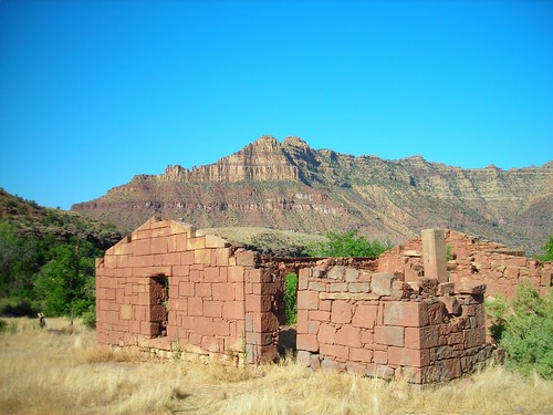
After Cow Swim, next stop was the historic McPherson Ranch. Which is a scary place.
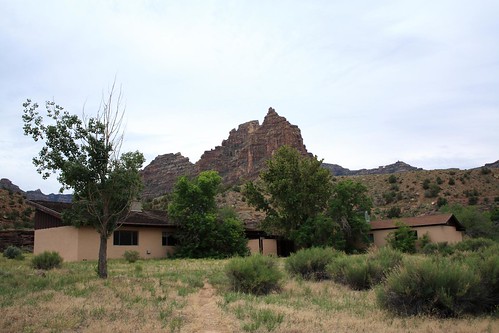
The ranch is promoted by the Belknap guide as a visitable destination but apparently it is privately owned today by the Utes, and visiting it is legally ambiguous. We checked it out. Approaching nervously, we agreed it looked like the kind of place where cannibals hang out waiting for you to trespass so they can have an excuse to kill and eat you. Something like the "House of a Thousand Corpses."
Old Jim McPherson himself was a homesteader here who lived here with his family around the (last) turn of the century. It was hard, isolated living, and they ran cattle in the Canyon. McPherson also traded horses on some occasions with members of the Wild Bunch "gang", whose numerous successes were largely due to meticulously well planned getaways, which were often aided by friendly locals who didn't mind swapping a horse or two for others that were tired and came with cash to compensate the owners. Eventually in 1940 Jim's daughter Pearl and her husband Budge Wilcox, who had by then bought the place, sold it to the Utes and moved away to easier living elsewhere. In the 70s' the Utes built the more modern buildings and experimented with running a vacation resort here. Eventually they gave up and today the place is abandoned and generally dilapidated. But there are picnic tables, and "modern ruins", as well as the older historic ruins of the original McPhearson ranch and corral behind the newer structures.
I approached a bit closer to look at the older historic buildings. I stared at them for a while. It was quiet. I turned around. Tyson and Chris were Gone!
I marched back to the boats.
There they were.
"You know guys, it is a pretty sick trick at a sketchy place like the ruined McPherson ranch to just quietly 'disappear' like that. I mean, anywhere else, whatever. But a place like this. Man. Don't scare me like that."
We shoved off.
And made haste for Three Fords, the last major rapid of Deso (though Gray Canyon, which starts immediately after Deso, also has rapids). I remember having heard something about it, like it was worth scouting maybe.
As the river curved to the right we stood up in our duckies, as we had before "reading and running" every other rapid save one. The riffles looked harmless. What hype! What nonsense! A bit disappointed we started round the bend.
Oh, there's the rapid. It's around the bend. You don't see it at first. In this picture from someone else's trip's website, the rapid doesn't look that intimidating. That is because that picture was taken at a higher water level when more of the rapid's features were washed out. As we ran it, there were big hits, duckie flipping holes, and, well, it was a lot of fun.
I didn't notice it as I was in front, focusing on getting through the waves myself, but behind me we had our closest call to a flip thus far (I don't count the flips in Cow Swim as real flips, because we were running it unloaded, and being playful). Apparently, a wave knocked Tyson out of his boat. Finding himself popped up right next to it by the buoyancy of his vest, Tyson grabbed the vessel and climbed back in, to finish the rest of the rapid without me even knowing what had happened. Great job!
Part Three: Bonus Canyon
And Deso was done. The separation between Desolation and Gray Canyons is not just characterized by a change in color and Geology but there is a mile of flat, open meandering separating the two. Here is a picture looking back upstream, from one canyon to the next.
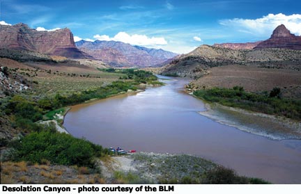
We looked back and admired the familiar, friendly, brown cliffs as they stood out, and then suddenly, ended.

And then, bang: Bonus Canyon.
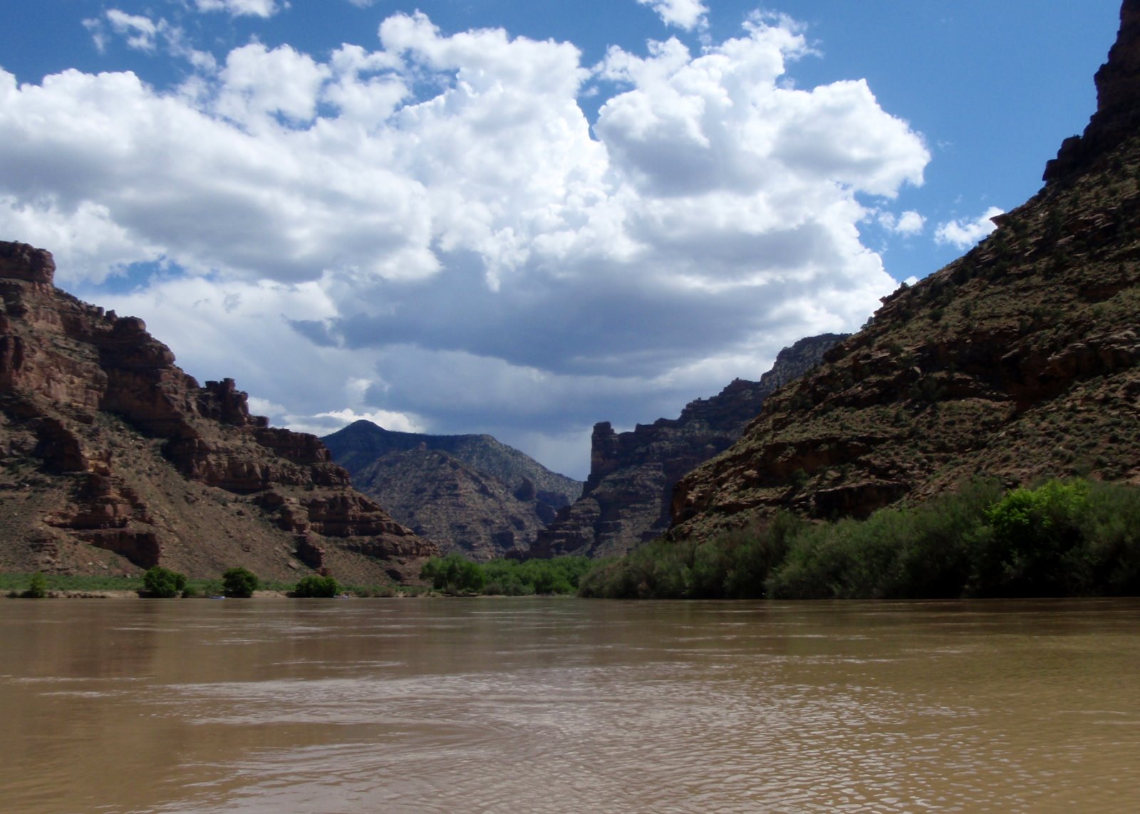
When you do Desolation Canyon, for the price of an ordinary Desolation Canyon Permit, you also get a second canyon, free! It is a pretty good deal. The second canyon you get is called "Gray Canyon", because the Mesa Verde Sandstone that makes up its walls is grayer than a lot of the red-orange Wasatch Formation that dominates most of Deso. Gray's walls are pretty tall, as we'd soon discover, but they are of lower, "Book Cliff" altitude as compared to the higher, and more densely forested, "Roan Cliff" altitude. Less vegetation makes the canyon look grayer as well.
At the beginning of Gray Canyon we found some large boulders of collapsed Mesa Verde Sandstone that had fallen into the river. Mesa Verde Sandstone was deposited by river sediments that carried material from the Sevier Uplift of today's Central Utah to the eastern swampy low lands where once existed the Cretaceous Sea. This sea at its fullest extent stretched from the Arctic to the Gulf of Mexico. By the end of the Cretaceous it had retreated and disappeared, as the Laramide Orogeny started to uplift the rocky mountains and raise the sea bed above sea level. The grain sizes of the Mesa Verde are larger and more coarse the further you go to the West, where you had the source of the sediments. Inter bedded with the sandstone are many coal seams, varying in thickness, some of which are quite thick.
It was from that rather useful material that Carbon County got its name, branching off from Emery county to manage its own, carboniferous affairs in 1894. Mines sprung up along the Book Cliffs and the Wasatch Plateau. The Coal they mined was used to fuel the Denver, Rio Grande and Western (later, Union Pacific) Railroad, as well as the heaters, smelters, and stoves of Salt Lake City. Numerous towns, some still thriving off the fossil fuel, others dilapidated and half abandoned, and still others true ghost towns, dot these hill sides today. They have great, mysterious, Western names like Hiawatha, Price, Wattis, Helper, Sunnyside, Kenilworth, Castle Gate, Castle Dale, Huntington, Mohrland, National, Spring Canyon, Coal City, Winter Quarters, Scofield, Mutual, Rains, and Peerless, to name several.

Be sure to check out the Western Mining & Rail Road Museum in Helper if you are interested in this kind of stuff. Plan to spend plenty of time, and don't over look the basement or the attic, for that is where some of the most interesting exhibits are kept.
You might be wondering why Mesa Verde Sandstone is being talked about in Utah. Isn't Mesa Verde an Anasazi ruin in Southwest Colorado? Well, it is! The Mesa Verde Sandstone is a huge deposit, with out crops all over the four corners area. You can find it North of Vernal, West of Hanksville, South of Farmington, and East of Grand Junction. And if you are an Anasazi Indian, you may find between its ledges an ideal place to build your house.

There are no proper dinosaur fossils in this, the last Cretaceous deposit of the Colorado Plateau. However, whilst trampling through marshes of decaying plant matter the dinosaurs left behind numerous foot prints that were preserved through the millenia while the peat was turning into coal. Finally in the late 1800s they were rediscovered hanging down into the roofs of coal mines by confused miners. There are a few on display today at the Helper Museum. Many of them are thought to have belonged to a species of Iguanadon.

On our trip we saw no dinosaur footprints and we mined no coal. However, we did enjoy parking our boats behind and climbing over the ancient boulders that had conveniently fallen into the river for our entertainment. We took frequent breaks to stretch our legs and "summit" several. On one or two occasions we were even able to maneuver our craft through "caves" between undercut boulders and the shore.
We soon came to another ruin, this one below Coal Creek Rapid. Coal Creek was a fun rapid, but the giant "hole" pictured in the Belknap guide was a tiny remnant of its high water self by the time we ran it.
The ruin walls were old.


Did you notice the cactus growing on the roof?
Chris explored a bit of an old road grade.

It went along the cliff river left, and for some miles distant we could still discern its outline parallel to the river. What work it must have been to make! And when did they make it? Do you build a road to the home stead and then build your home, or do you build your home first, and then build a road? If the former, where do you stay while building? And if the latter, how do you get building materials into the homestead in the first place?
Surely not by Iron Prowed Skiff!
These and other questions circulated about in our minds like the little bits of suspended sediment bumping along the river bottom, carving the canyon ever deeper.

We paddle a little further, and start to think about dinner.
* * *
This is a picture of Tyson and I at our last campsite in Gray Canyon.

It is not much of a picture of the campsite, and it is more of a picture of Tyson walking and me fiddling with cam straps. That is ok though, because we look like pretty awesome and experienced river runners in this picture, and there is nothing wrong with that.
It wasn't much of a campsite, just a little peninsula of mud and rocks with a little sand and a few tamarisk and willow shoots eeking out a low water existence. Still there was enough space for a tent, some duckie sleepers, and a kitchen. It was hypothesized that the bit of still backwater might be an Alpha Cat pond, so we baited and cast a line, confident of the catch we'd be sure to get. After a few minutes of no bites we tied off the pole and played frisbee in the mud, which was every bit as fun as it was dangerous.
This campsite was just above Curry Creek, where rustler and sometimes train robber George "Flatnose" Curry was killed in April 1900- ambushed himself while camping there by a posse he didn't count on. Chris P and myself were almost killed here too. That is not because there was a posse chasing us, but because we decided on a whim at dusk to go for a peer pressure inspired 2,000 ft summit attempt with only a liter each of water to drink.
Peer pressure is a marvelous thing. I will admit it can get you into trouble and you can wind up doing foolish things sometimes with peer pressure, like... a lot of things I can't talk about here, or ever. That being said, I've also done some of the funnest things I have ever done because of peer pressure, and I have gotten myself into plenty of trouble and done plenty of foolish things all by myself.
This night's scramble was about equal parts fun and danger. I don't know whether it was right or wrong to have tried it, but I am glad it happened.
It all began like some kind of Holy Wood script. Here we were, late afternoon, at the last, or second to last, campsite of the trip. We had gotten there after a nice long day of paddling. Here's a picture that is not exactly where our campsite was but was taken in its approximate location and gives a better view of the contours of the Canyon Walls. This view is looking back upstream and is about the same view (though more obstructed) that we would have on our climb.

Tyson had gone off for a rest. And I was about to do the same thing, lying in my duckie rather comfortable with some warmer clothes on and reading about the Wild Bunch. All of a sudden, here comes Chris. He's got his hiking boots on and he looks like he's about to go do something. I can't tell what. He's walking around our little peninsula trying to find a way off it and staring at the cliff on the opposite shore.
"Hey Chris, whatcha doing?"
"I'm thinking bout going for a scramble."
"Up them cliffs?"
"Yeah."
"What kind of scramble?"
"Just a mild scramble."
"You mean like, just a liter of water worth of scramble?"
"Yea... just a little one. I wanna see if I can get to the top of that cliff."
"That one right there?"
"Yeah."
"I think I might be up for a mild scramble. Tyson's sleeping. Why don't we take his duckie and use it to paddle across the Alpha Cat pond, so as to get to the cliff?"
"That's a good idea."
So we get the duckie and we paddle across the Alpha Cat pond, and we go a- scramblin' up the cliff. Chris finds a route through the sandstone ledges that takes us up to the next, slope forming area.
Gray Canyon is not as deep as Desolation Canyon, but it is still pretty deep. You're cutting through the Book Cliffs now, whose tops are really mesas, large, flat, and back sloping mesas. The back of this backsloping mesa we were on was cut by the rivers' canyon.
"Hey Chris."
"Yeah?"
"How high are you trying to get?"
"I wanna get to that point right there."
"That rock outcrop thing on the ridge?"
"Yeah."
"Cool."
We come to the base of another cliff, much like the cliffs that had frustrated our progress to summit the canyon the previous day. This time, however, the cliff is not as smooth. It is more "bumpy", and there are eroded, fallen down pieces we can climb on. Near the top, we actually climb under a fallen ledge, through a "hole" in the rocks, and get to the top of the Rim.
We continue up to the point.
The view is well worth the hike. We can no longer see Tyson or the camp. It's been cut off from view by the angle of the cliff. However we can see the river upstream and to the left, before it curves out of sight to the right. The great Roan Cliffs of the West Tavaputs Plateau are fully in view as their majestic slopes are tinted pink by the setting sun.
"I bet we can make it up there."
"It's getting late."
"Yeah, and we don't have much water."
"We better do it fast."
"Yeah, just don't get clumsy and fall off."
"Lets go!"
On and up we went. Up slopes of eroded, steep grade sediment. Stepping on rocks, which usually didn't give way beneath our weight. Carefully as a guide and as an aspiring park ranger, Moabites both, well aware and experienced of the fragile, nitrogen fixing, erosion retarding cryptobiotic soils we carefully avoided, lest a rouge foot print be allowed to fall upon a dark patch and set back the colony's growth a decade or two.
We got pretty high. The clouds that had been marvelous were much more marvelous.
"I bet we can make it to the top."
"I'm almost out of water."
"Yeah me too, but if we hurry, we can get to the top about the time we are out of water, and then it is all down hill from there."
"We might be coming down in the dark."
"Good thing we didn't bring our flash lights on our evening scramble to the top of the cliff in Desolation Canyon just before night time."
"Yeah. Good thing we didn't bring matches, or a first aid kit either."
"Or a whistle. Or warm clothes, or extra water."
"Yeah. Good thing we live in Moab and know all about the desert and we're wilderness professionals."
"Yeah. Good thing you spent $6,000 on Park Ranger school to know all about how to go hiking safely."
"Yeah good thing you spent $450 on river guide school to not get hired."
"Dude. We can totally summit."
"I don't know if we're going to summit this mesa tonight"
"Let's go!"
Higher, higher, we wound our way through gnarled juniper and pinon pine, and cactus, in its small and runty varieties, far enough apart to forget about while walking, though close enough to consider when reaching for handholds. Another ledge of rim rock. Another sneak. Another climb up its separated boulders, split apart by eons of wind, rain, and frost freezing and thawing, to produce just enough space for a tall skinny guy with high metabolism to squeeze between.
I don't think that George "Flatnose" Curry ever worried too much about cryptobiotic soil.

And finally,
The ledge is in sight!
The top of the mesa, surely. And how fine the good earth looked behind us! How majestic were the ridges and the cliffs in their painted glory! The blue mesas! The Sagebrush Desolation!
"I think this is about as far as I am going to go."
"Hmmm."
"We're pretty high. The top is right there. And even if we got to it you're not going to be able to see over the other side anyways."
"Yeah. Hmm..."
"Hey Chris."
"Yeah?"
"I'm gonna leave my water bottle right here. That way I won't be tempted to keep on going forever. I'm going for the summit."
"Are you kidding?"
"Nope."
I reach the top of the last cliff.
"Good thing we didn't bring a camera!!
Of course, as I had known before hand, "summit" is a really inferior word to use in conjunction with the backsides of Book Cliff mesas. I knew, very well, that these cliffs had not so much "peaks" as rather rocky terraces cliffing out here, there, in ledges of various heights before their flat topped juniper forested "summits" backslid to the North, away from the very view I had hopped for all along, but which I knew would have been impossible to reach tonight. The edge of the cliff could have been a mile or more away, through the thick, woody scrubland whose lush density remains completely unknown to most I-70 travelers, only able to gaze from afar upon the cliffs as barren, lifeless, sandstone faces.

No- the Book Cliffs are a mirage! Concealing not only oil and gas wells but an immense Wilderness Study Area, miles and miles of hiking, wildlife, wash exploring, cliff climbing...
"Hey Chris!"
"I'm over here!"
"Oh, cool. There you are."
"How was the summit?"
"It's pretty sweet man. It's a lot like here, but it's a little higher, though you can't see over it because it's a mesa that slopes uphill slightly and you can't tell how long it goes on."
"I think we're going to be hiking downhill in the dark."
"Yeah. We should probably get started."
And then, of course, even swifterly and more carefullier we proceeded, faster than the ascent had been. In the distance, up stream, we could see the camp fire of our fellow group of hypalon bucket boated river runners. We held up, on this prominent cliff, and tried to think of something intelligent to yell off the top so as to at least share and announce our feat to the world. We yelled.
Further down, through the narrow slit, down the ridge face. No, not this way, that way! To the right! Down down down, careful, sliding rock. I need to pee but I am out of water. Chris has lost his water bottle. His shitty carabiner, attached to his belt loop, ripped out the loop and rolled down away some unknown wash or gully unnoticed minutes ago. It is lost forever. I wonder, who will ever hike here after us? Anyone? Will someone find it? Will the bottle lie there and rust? Will it be carried downhill by the erosive forces of the Green River and deposited, eventually, onto some point bar or mud bank whence, millenia later, future archeologists will one day discover and revive the object, speculating and tale telling one another ideas about the race of men who once ran rivers in PVC boats and who climbed cliffs at Twilight with no flash lights or matches or warm clothes, only to loose their water bottles on the way down!
Only time will tell. But for now, I need to pee. But I am saving it. If I have to drink pee, I want to drink this nice, well hydrated, relatively clear pee. If I pee now the next pee will be more concentrated, yellowish, stinky pee. But I want to get down and off this mesa. I don't want anyone to drink pee. Because we have two guys and one empty water bottle, and every pee drinking scenario I can think of is a bad one. I push the thought out of my mind.
Suddenly, a whistle!
We yell back, "We're OK!'
Tyson, evidentally roused from his slumber, has discovered it is night time and his companions are missing. Intelligently he has found the whistle on my life jacket and blown it across these vast distances, too far for the human voice to itself ascertain our condition. We're happy he has found it and he has checked up on us though as a general principle I get nervous about any whistles blown in the wilderness, lest they disturb some other party of fellow adventures into thinking some real true emergency is taking place.
The last cliff. The cliff we scrambled. We're cliffed out.
"How's it going?"
"We got to the summit!"
"Didja hear us yell?"
"No."
"It was pretty sweet."
"How are you gonna get down?"
"We climbed up that cliff."
"It looks pretty steep."
"Yeah."
"Good thing you were able to fix that super expensive REI Caving light that sucked and broke!Can you shine it over here?"
"Like that?"
"No, not that high, you just destroyed my night vision. On the cliff, below us."
"Oh, okay."
"Thanks."
Slowly, carefully, we retrace our route of the initial, brief, "scramble". Where is the duckie? Oh there is it, at that path. Get in, shove off. Paddle back across the Alpha Cat pond.
"Did you check the line for Alpha Cats?"
"No."
Checking the line we find the world's smallest baby catfish. Removing it from the hook we set him free. Clearly, Alpha Cats had been breeding here just months earlier. But where were they now?
"Hey Tyson, what would you have done if you woke up and we had disappeared and it had gotten dark and we had not come back?"
Part Four: Desolation

Some canyons hit you over the head with the full force of their capacity the moment, or just moments after, you have entered them. Pritchett Canyon in the "Behind the Rocks" area of Moab is like that. You don't even have to go there. You can just hang out at the hostel and listen to stories of Torrey getting lost there and spending the night shivering in 40 degrees in a tee shirt and a space blanket with Chris. Cataract Canyon is the same way. You can't get near Moab without hearings stories about it. You can't camp out at red lake below the Confluence without the solemn ominiminity of upstream flash floods raising the water level and turning the waters beneath your raft into chocolate milk. And that wave, that launch pad at that certain water level on Rapid Five, taller than a car is long and passing just to the right of my boat. I will never forget that wave.
"Desolation" Canyon, I have found, is very different.
For us, we were welcomed with open arms. The road was good, the ranger was friendly, the campsite was ok, our permit was in order, the petroglyphs along Nine Mile Canyon road were nice, the truck handled the road well, the other rafters were friendly, and the bears were non-existent. We were allowed through the canyon and through its successor canyon. We ran the rapids and the food didn't go bad and was great and we all survived and had a good time.
We would not really understand about The Desolation until the last day, the day we got off the river. The day we tried to eat at a restaurant in the town of Green River, Utah. The day we did the shuttle in the dark. And the day we woke up on a Sunday and found ourselves with car trouble deep inside the Uinta Wastelands. Some of my comments, here, you may find to be gnarled with bitterness. Remember that I do laugh, because I have to laugh, and in the first and foremost picture of this article you see me laughing as I replaced the tire. But this is my article. That was my tire. And it would be a lot of extra money and wasted time before I was back in Colorado. So I will make no apologies for the poignancy of my observations.
There had been this strange, ongoing theme throughout the trip, where my meticulous planning of campsites and river miles beforehand was questioned and doubted at least once a day. And what threw us off so bad on this last day? Not my own plans, but my catering to a change of plans, allowed at a time I should have held firm and asserted my "authority" as trip leader and shuttle driver.
"Are you sure we're only paddling 3 miles on the last day, and then driving home?"
"Yes."
"Let me see the map. It looks like of like four miles."
"It's three. Which is about maybe an hour, max, of continuous paddling. You'll have all day to drive home and we'll have all day to do the shuttle."
"I hope so. I need to get back to put my stuff away and plan the week."
"You'll get back in plenty of time to crawl back inside of your finance. Don't worry about it. You have to relax. We are on the river. If you can't chill out here and stop worrying about plans there is no hope for you."
We launched.
We paddled.
There were some fun rapids. Not major. Just fun little ones.
We talked. We decided, instead of sticking to the plan, to just finish Gray Canyon that day. 16 miles. And then five hours in a car to do half the shuttle. For better or for worse. Though of course it would be worse. But you have to acknowledge this directly, and accept responsibility for it. You can't shy away from your decision. You have pass for one last time the amiable flotilla of fellow rafters you have been passing every day and on this last day when you are still paddling you will have to talk to them when they will ask you,
"So are you guys doing another day or are you taking out today?"
"We're taking out today."
"Yeah, that way we get to do our shuttle in the dark!"
"You're doing your own shuttle?"
"Yeah, it's a helluva shuttle."
"That sucks. When we get to the takeout, our cars will already be there for us."
"That sounds pretty nice."
"Yeah, it is!"
"Can I have another PBR?"
"Sure."
16 miles the last day. Paddle paddle paddle.
Throughout the trip I had been marking campsites, sandbars, points of interest, on my Belkap guide. Today I let it go. Not because there weren't still campsites to consider. I just wasn't thinking about it. It was time to paddle. Not to write. The point was to get off the river, and to get to this shuttle as fast as possible so that I could get it over with as fast as possible. It is, God willing, five hours each way from the take out above the town of Green River, to the put in at Sand Wash. 57 miles on I-70 and US 6/ 191 to Wellington. 68 miles on paved - dirt - paved - dirt- shale roads through Nine Mile Canyon, with the final 30 miles spent driving at 15 miles an hour over the tire shredding daggers of Green River Shale on Wrinkles Road. Five hours each way. About. If nothing bad happens.
Focused soley on the taking out I didn't make a lot of notes but I did enjoy the waves. Nothing too difficult or technical or big, just fun waves the whole way. I didn't even notice the Price River coming in stealthily on the right. The Price, much like the San Rafael ( 1, 2) or the Duchesne, is a small, lesser known desert river. Effectively choked by Scofield dam and mostly irrigated to death, in wet years when the snow melts there is a short boating season on it. In their narrow channels the Price can become a class five run. Its path is also a geological marvel, cutting a canyon from open desert directly through the book cliffs, only to feed into the Green just a few miles before the Green itself exits the cliffs.

Check out Durango Bill's page to learn more about the geographic marvel that is the lower Price.
Takeout day is always strange enough, even without a shuttle to run.
On the river, everything has a way of just making sense. There are no bank accounts. There are no bills. There are no voicemails or text messages or emails. There is no advertising. There are no television programs. There is no celebrity gossip. There is just a river, some people, some boats, and some adventure. You can plan all the stops and campsites and meals in the weeks before. But here, now, you can basically do whatever you want and pick your own schedule. You can reach into coolers and dry boxes and cook whatever you want, whenever you want. You can stop wherever you feel like it, not where you have to. Flat water, white water, it doesn't matter. River running in the West is about the freest, funnest, and (especially with private trips) most unregimented form of life you can find anywhere. Things make sense here in a way they don't, it seems, most places.
Even your body agrees. The act of floating on a boat prompts the brain to release greater amounts of dopamine and serotonin. It's good for you, and highly addictive.
Getting to know people on the river, the importance of skills you've learned, the success with cam straps you've eliminated from your rigging by more efficient rigging, the constellations you know, the Wild Bunch, the history of the lonely cabins, the discovery and identification of animal remains, the proficiency of catching a frisbee while sliding in the mud, the accomplishment of righting your flipped vessel, getting back in, and finishing the rapid. How to set up for a perfect line. Yes.
And then, No.
No more. Not now. Now. It is time again for debit cards. For Fall plans. For negative cash flows. For cleaning out the river shitter. For flat tires, music, personal obligations, and 2.5 months of unemployment and living in a car until the ski resort opens. For walking on pavement!
The car is still there. My key is still where I hid it. It turns on.
And then everything happens so fast. Boats washed and deflated and rolled. Gear emptied, sorted, returned, stolen, "donated", and before you know it, the comradery that developed between strangers, customers, guides, and friends old and new begins to fade. Torn apart and replaced by a physical absence, by the irresistible forces of jobs, rent, housing, fiancees, breweries, and girlfriends in Durango.
Driving back down the river road, I don't turn my phone on. That final, significant, re-integration back into the Twenty-First Century I will postpone for a while.
* * *
Let's eat dinner in Green River.

The Tamarisk Restaurant ("This restaurant serves plain basic food"), fittingly named after a noxious invasive specie, is a happening place tonight. Plenty of cars and trucks parked out front. Right here, along the East bank of the river. Hell, we could eat here without even having to go in to Green River at all.
No. Impossible.
No way could we do this. Green River is the dictionary defined, picture book story-tale of small town America in decline. We felt compelled to support it.
Once upon a time, before I-70 had made its way this far, were the proud old days of Highway 6: The Grand Army of the Republic Highway. In those days, passers by would be forced to slow down and drive through the town proper. They'd pass its rows of kitschy businesses and weary travelers would decide on a place to eat by how it looked, rather than because they recognized a certain brand logo on a blue metal sign 300 yards away at 75 miles an hour.
Then came the end of World War Two, the dismantling of the street cars, the spread of the automobile, and the idea of a nation wide interstate system. But I-70's present route West of Denver was never a forgone conclusion. Original plans for a nation wide interstate system drawn up in the 1940s had the freeways stop in Denver, going to the North and South and East of the city but not through the mountains. The state of Utah was perfectly happy with this, and saw no need to build a parallel route to I-80 through the remote, rugged, and thinly populated Eastern part of the state. Congress agreed. Legislation had only budgeted the construction of 40,000 miles of interstate, and all of them had already been allocated. It wasn't until 1956 than an act was passed allowing the Bureau of Public Roads an additional 1,000 miles of roads to plan. Sure enough, Colorado's incessant lobbying for a Western route would take half of them.
Salt Lake City was not impressed. Not at first, anyway. I-70 was not designed to serve the Wasatch Front at all- that part of the state where the great majority of the Utah's population was concentrated. The new road was primarily designed to facilitate a route from Southern California to the Denver area, by connecting with I-15 at the historic (though economically insignificant) junction of Cove Fort. Sloppy public relations by the Bureau of Public Roads- announcing the new route at a press conference before informing Utah of its final route decision- surprised and angered many. But not all. Southern Utahns, at least, were happy. Some time passed before the Utah State Road Commission finally came around to realizing that shortening the Denver to Los Angeles distance by 200 miles was in the national interest. Certainly at least the economic boost of today's tourist dollars would be a fraction of its actual self were it not for I-70 and its opening of the Canyonlands.
Of course, Utah prioritized updating its heavily trafficked Wasatch corridor before devoting time to I-70. The interstate didn't make it past Green River and through the San Rafael Swell until 1970. The last few miles- in Colorado's Glenwood Canyon- were not finished until 1992.

Here as elsewhere when interstate surveyors mapped their routes they would often place exits just outside of the town proper. In the above photo, you can see the actual town as indicated by the presence of trees far off in the distance, quite a bit away from the on/ off ramp. Such planning would have a transforming effect on numerous small towns. Downtowns would decline. The way they had grown up around the earlier highway traffic no longer suited the needs of interstate travelers looking to "waste" as little time as possible getting gas or a bite to eat as they "passed through." The basics of gas station, restaurant, and motel commerce were superseded by new construction at the off ramp outskirts. The interstate, passing just a few hundred yards from main street, but with off ramps a few miles away "to allow for growth", eventually killed the neighboring town of Cisco. And it would have killed Green River too, were it not for the namesake river that continues to give melon farmers, river runners, and a few gas station attendants reason enough to hang around.
Today flanked by a pair of gas stations at each exit, and one or two functioning motels intercepting travelers before they have a chance to even get to the town itself (where they might be tempted to actually purchase something!), "downtown" Green River looks more like just another Mancos Badlands ghost town than any place you'd expect to find a real sit down and eat restaurant.
How unnatural, really, for us to try and eat there; to support this dying downtown. Pretty soon I-70 will have existed longer than the old US- 6 / 50 route... just as eventually (the effects of diorhabda elongata notwithstanding) the evolutionarily superior non-native Tamarisk will in one way or another replace much of the West's native cottonwoods and willows. What strange beings we are, to cling sentimentally to the past- to evolution's declining, outmoded, and inefficient designs! Deep down, does it make any more sense to mourn the loss of Historic Downtown Green River than it does to more the loss of the equally Historic Allosaurus Fragilis? Or the Three-Toed Sloth? The Anasazi? Or the Cottonwood?
Logic has its merits. But we have never been logical beings. Romanticism, emotion, beauty, love, attachment... things familiar and the memories of things lost... have always been more important to more people than precision or efficiency. Our conceptions of ourselves are more important to us than the reality of our lives. Our polity and environment tends to suffer from the same handicap. What a beautiful and perplexing specie! How psycologically advantageous the weight of known conservatism! How rare and reckless innovation and revolt!
Just as we would pay a price, against all logic, for our decision to support a dying downtown restaurant in Green River, we as tax payers continue to pay for our inability to accept the definative superiority of natural selection's track record for decision making. To fight the tamarisk every year we devote over $15 million to an uphill battle. At the same time that the State of Arizona balances its budget by cutting its funding for heart, lung, liver, pancreas, and bone marrow transplants, it puts hundreds of thousands of dollars into poison, chainsaws, and man hours to remove a better adapted species from its waterways- a species that every indication of increasing population, decreasing snow pack, and dissapearing aquifers suggests is likely to outlive the cities of Phoenix and Tuscon.
I wonder, after we disappear, will any future archeologists- perhaps while pondering the fossiliferous remains of some Quaternary landfill- evolve the same capacity to romanticize quaint inefficiency that we have?

Tamarix Chinensis- last guerrilla warrior of the Far East. Wearing down the empire, losing every battle, and winning through attrition.
"They'll spend a million dollars to kill one Gook!"
We headed into town. A mile of boarded up windows and cracked neon signs. The padlocked doors of economic decline.
A closed hotel. Another closed hotel. A third closed hotel. Closed restaurants. A closed gas station. Another closed gas station. Empty storefronts in every arrangement of spatial relation closed. Next door, closed. Caddy corner closed. Across the street, probably closed. Closed motels.
"Dude, what the fuck is up with Green River?"
"I'm not sure this is going to be the easiest place to find something to eat."
"Let's keep going and find out. There's got to be some kind of authentic, mom and pop type small town diner still alive here somewhere."
"Yeah. There's gotta be."
Welcome to Green River.


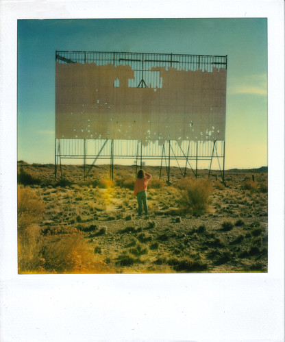

Finally we see something that is open. A small Mexican restaurant. All right!
I love small town Mexican restaurants.
Except for this one.
"This is your choice."
Oh the staff was nice, and by that I mean the guy there was friendly. We really do wish him all the best, and about everything I am going to say I know how he feels. I have been that host / waiter / bartender / manager / busser of a small, sad, slow restaurant before. It is absolutely with no malice of my own towards him that I recommend to all of you never to go there. In fact, I cannot in good conscience avoid recommending to all of you never to go there.
We should have listened to the warning signs.
The Rape Me / Rob me ATM, in the dark corner of the parking lot, sort of crooked, and probably not working. Probably abandoned there after it was stolen. And probably not missed enough to have been replaced.
The dim interior lighting.
The sad, lonely, "Yes, We're Open!" sign, taped in desperation to the window, trying just a little too hard to make up for the overall drab appearance of the faded, 1950s era paint chips peeling off the exterior walls.
The employee's friends and family seated next to the window, pretending to be customers ordering things but not eating, making it look to innocent passers by that actual people actually eat here.
The bathroom. The floor in the bathroom. The floor in the bathroom that probably hadn't been mopped since the previous owners were murdered fifty years ago. The razor blade by the urinal. No. Not a shaving razor, forgotten by the sink. A razor blade. Clearly, they must come standard with all Green River bathrooms, just in case the overwhelming sense of despair and futility ever gets too great. Cause, I mean, then at least you'd have options.
The blinds were drawn on our booth, window facing West on Main Street. We opened it to counter the gloom a little, and in case there was a shooting or mass suicide while we were eating we didn't want to miss it. Did I mention we had a very long shuttle to still do half of that night?
We sat for a while... taking it all in.
"Why the hell did that guy want to leave so early anyway?"
"So he could finish the trip early and drive into an elk at night going up Vail Pass?"
"That's not a good way to get home to your girlfriend."
"In a box?"
"Yeah."
"He'll probably be okay."
"At least he's not trying to eat at a restaurant in downtown Green River."
"He's going to get there at like 1 AM and wake her up getting in."
"I don't think most girlfriends prefer to provide gratuitious welcome home sex when they are woken up at 1 AM by a guy who hasn't taken a shower in 9 days."
"We really need to bring females along next time we do Desolation Canyon. All that guy ever talked about was his fiance, and all you ever talked about was how cute that girl with the rafters was."
"It would probably provide a more balanced and intelligent element to our night time conversations."
"The reason I go to Desolation Canyon is totally to have intelligent and balanced conversations while drinking hot chocolate and tequila."
"Yeah. Good thing you moved to Utah!"
It's pretty hard to screw up Fajita. Yet, we probably should have taken a hint from the glimpse of our salsa coming out of the Arizona Iced Tea jug kept unrefrigerated in a cupboard, and ordered even more conservatively. We didn't, so I got the special.
What I remember most about the Fajita special were the beans. Not that they were that great. But there actually were beans. I know because I spent a long time searching for them in the tepid brown water covering half of my plate. I looked a few times. Yes, there were beans in the water. I am sure of it. Well, that's a relief. And the rice is okay. Cold of course, but okay. Though, when you think about it, it's pretty hard to screw up rice. That's kind of like getting an A in class for managing to show up the day of the test.
I remember going back and forth for a while between the chicken and the beef, trying to avoid one because of how it looked before switching and deciding that the other actually looked worse. There was some kind of pale, tepid, mucousy paste coating the chicken, and the beef if poked too hard seemed dissolve into marrow and spice. We ate slowly and some times stared at each other, and smiled, thinking the same thoughts, the same answer to the same question!
Though this wasn't, really, how the meal after is supposed to go. But there are times you just have to laugh and smile. They tend to be more frequent in a recession.
Not the concluding meal to a successful trip. No. This was a different meal. A new meal. The trip had ended back there on the boat ramp. This was the meal before a whole new chapter of adventure. And for temperature, quality, and taste, it set the tone perfectly.
"He said 10 minutes--we waited for at least half an hour. The food wasn't very good (not very healthy either if you care about that)."
We should have gone to Ray's instead. "Where Everybody's Welcome". Nope. That would have made too much sense. No one moves to Utah for logic.
Deciding to make another mistake we asked the waiter where we could buy some alcohol. It's a Saturday. This is Green River. It's 6pm. Of course we should be able to buy alcohol. He gave us directions. We followed them. A bit down main, turn left, and go down.
We found the store. It had a nice, neon "beer" sign in the window. The only problem was that it didn't look like anyone had flicked the switch for a decade or more. To be fair, some of the glass in the windows wasn't even broken- just covered in dust. We should have suspected as much.
"I don't think this place is open."
"I don't think this place has been open since you or I were born."
"Well, the last time that waiter ever thought about alcohol, it might have been open."
"He probably just hasn't checked since then."
"Yeah. He's a pretty nice guy. He just doesn't know."
"They didn't even have beer or tequila at that restaurant."
"We never should have trusted them. How are you supposed to trust a Mexican Restaurant that does not have beer or tequila?"
"Every Mexican Restaurant has beer and tequila."
"They have hundreds of different types of beer and tequila."
"Every one but the one in Green River."
"We'd probably have had better luck if we asked for meth."
Giving up completely and pulling out of town, we failed to notice any spectacular change of momentum at the gas station. I pumped while Chris set off for an ATM. I left him there, with the fat lady in a blue dress, with too much blue eye makeup, and no money trying to find out
"Where'd that cute boy with the hat go?"
"Hey you, how'd you get that machine to work?"
While I focused on more important things, like whether I'd rather have a fake mustache, or a "guns and grenades" key chain from the coin operated machines at the front of the store. Most likely, like a lot of these hairstyles, relics from the Cold War...
"Let's go to Sand Wash."
* * *
And who would have guessed, but we got there, hours later, with no problems! The Subaru did it! Fully loaded with all the gear from the trip as well as with an extra human in the passenger seat! Those new tires I got after the blow out in July musta'did the trick! No flats, no bearings going out, no falling into holes, no clutches dead. We were stoked. After setting up our tents Chris made another patented roaring fire. And we did the best we could to finish off the extra hot chocolate and tequila rations. One last night of camping in the desert. One last night in Utah. The last night of the summer. Best river trip in Utah.
Such a successful night. Therefore, you can imagine my astonishment the next day as I got out of the tent and looked at the car.
Yup.
It was exactly what I thought it was.
"Hey Chris."
"Yeah?"
"How's it going?"
"Pretty good."
"Wanna know something fucked up?"
"Uhhh.... okay."
"Check out the car and tell me what's wrong with it."
"hmmmmm..."
"Woah."
"Yeah."
"That tire looks kinda flat."
"Chris, that tire is flat. It is a flat tire. We have a flat tire at Sand Wash ."
"Do you have a full sized spare?"
"I got that donut. But I'm not sure its a good idea to drive to Wellington on that thing."
"It's pretty far, and that road sucks."
"Let's ask the ranger what he thinks."
There was a new ranger. He was still a friendly, helpful, knowledgeable BLM ranger to be sure. But he was a different guy that the one who had greeted us a week before.
"You know, that ranger might have a pretty good thing going if he got himself a patch kit and learned how to patch a tire. He'd have a pretty nice little side business there on the side."
"Yeah. But. I've always heard that Roosevelt really sucks. At least now I finally get to go there."
We headed to Roosevelt.
Roosevelt is a small town in the Uinta Basin, which is sort of a black hole of the desert. With the exception of Fantasy Canyon, tourism is generally restricted to the basin's margins- to the North in the Ashley National Forest and Dinosaur National Monument, or to the South where a few thousand people a year run Deso and an equal number of hunters visit the Book Cliffs in search of game.
The Green River goes through the basin, but almost no one runs this stretch of it. The whole hundred mile section is completely flat with only oil and gas wells to break up the monotony. Most people take out from the Green's scenic run through Dinosaur at Split Mountain, just at the beginning of the Basin proper. High use boating starts again back at Sand Wash where the basin ends. Only then really does scenery change, civilization fade, and cliffs, rapids, and wilderness begin anew.
One rarely finds a piece of vegetation in the entire basin, other than someone's personally planted and watered tree, higher than a sage brush. No National Park here. No National Forest. Not even any forest to nationalize.
Half the basin, deemed worthless land at the time, was "given" to Ute Indians after the Meeker Massacre of 1879. They'd still be about as despondent today as they were then were it not for large natural gas and oil fields the White Man inadvertently demanded they re-construct their homes over. Of course, when gilsonite- a valuable oil like mineral- was discovered on the reservation, developers succeeded in getting congress to carve out a five mile strip from the reservation so Anglo companies could mine it. When oil and gas reserves themselves were finally discovered, they were simply too broadly distributed for such theft to be repeated.
The rest of the basin that is not Ute Indian land is either privately owned, or (and this includes the vast majority) is owned and managed by the Bureau of Land Management, that useful and contradictory Federal Agency charged with managing most of the 264 million acres of public lands in the West, which it does for the relatively modest price of just over a billion a year.

The BLM does a pretty good job of installing porta potties, building camp sites, regulating river use through permit systems, and encouraging safety and minimization of environmental impacts by making sure both commercial as well as private river trips have first aid kits, repair kits, life jackets and fire pans before they can launch. BLM rangers do not carry guns as often as park service rangers and they act less like cops. They are usually pretty friendly. A lot of them are former guides who love the outdoors as much as you.

At the same time, the BLM sells off mining and drilling leases to extractive companies. What kind of leases these are varies from place to place, but for much of Western Colorado, Eastern Utah, and Northwest New Mexico, these leases are for oil and natural gas exploration. It is comforting to read on the BLM website that "less than one percent of all BLM-lands is developed for oil and gas resources. " However, when you realize that one percent of all BLM lands (including the 700 million addition acres of subsurface mineral resources managed by the Bureau) is equivalent to 14,765 square miles of above and below ground area, which is the size of Massachusetts + most of Connecticut, it becomes clear that BLM leasing policies can have a big impact.
In the Uinta Basin, Oil and Natural Gas extraction accounts for over 50% of employment and 60% of wages. Add to that the service sector where these people and their families spend their money and you have practically the entire economy. While this provides jobs to a lot of folks (current population of the Basin is just under 50,000), extraction is also for good reasons looked down upon as a rather ecologically destructive way to make money. And of those who judge certainly many are the environmentalists, hikers, hunters, amateur geologists, and river runners- most of whom often cook at home over natural gas stoves when they're not burning oil and gasoline in their cars driving long distances to their wilderness adventures.
Vast fields scatter to the four directions away from the cities. There's black gold in the Green River Shale. In the Mesa Verde. In the Mancos and Dakota. There's enough oil and natural gas out here to keep most of the city of Vernal employed (in boom years) and to have transformed suburban Jensen into a parking lot of big rigs and fleet trucks.
Worldwide, there's another 60 years left of Natural Gas. Interestingly enough, this rather important fact is only found in the second to last sentence of the Department of Energy's latest 11,581 word report that praises Natural Gas development throughout. Undaunted by the ratio of short term benefit to global warming consequences, the same report optimistically predicts a 69% increase in our country's consumption by 2035.
Today Gas is a booming, providing 24% of electricity production in the US and 15% of electricity production in Utah. Here like the rest of the country, the great bulk of electricity- 82%- comes from instate burning of 17 million short tons of coal a year. For Utah the coal will last for fifty more years. All this ought to make things pretty interesting the time I am a crotchety 75 year old. I'll be able to preside over the decline, while leaving it to my kids to actually be affected by the search for alternatives.
"Make the Desert Bloom..."
In addition to the long term greenhouse gas impact, there is an immediate environmental impact of disruption of animal pathways, feeding grounds, and breeding areas that inevitably comes when you build roads, drive big trucks through them, and install heavy, loud machinery (1, 2, 3). And in a place like the Uinta Basin, where drilling is taking place side by side on private lands, BLM lands, and Ute lands, the entire landscape changes into something resembling the endless panorama of wells pictured above.

There's pretty much no reason to be here at all unless you are working for an energy company. Or unless you woke up one day to find out that, some time in the previous nights' drive to Sand Wash, a fractured tiny tooth of shale had lodged itself inside your brand new drivers' side rear tire, causing a slow leak, which by morning would be completely flat.
Roosevelt is closer to Sand Wash than Wellington. After assessing our options, we decided to go there first, see if we can get the tire fixed, and then go back to Sand Wash. And then do the second half of the shuttle.
"Thanks for the ride man. I really appreciate it."
"I wouldn't leave you hanging, bro."
"Yeah."
"But no matter what happens, I do have to be back in Moab tomorrow for work."
"That makes sense. I'm sure we'll find something open and get this fixed by then."
"Hey Christian."
"what?"
"Smile!"

And that's about as excited as I look, unshaven and sun tanned after a week on the river, suddenly re-inserted into the global economy in about the most frustrating way I can think of.
On a Sunday.
I didn't think about car trouble when I made Sunday the shuttle day on the trip plan. It never occurred to me. I am open Sundays. I work Sundays. Why wouldn't anyone else?
"I grew up in Roosevelt."
"How'd you like it?"
"I hated it."
"Why?"
"It's just awful. There's just nothing there. I was so happy to get out."
Maybe there is one good thing about going to Roosevelt on a Sunday to fix a flat. And that is that you get to experience and learn about an additional rock formation that most people that run Deso do not get fully acquainted with. We heard about Lake Uintah, and we heard that Green River Formation and Wasatch Formation were created by deposits into Lake Uintah. Okay. But then what is this stuff I hear about called Uintah Formation? What the hell is that?
Towards the end of Lake Uinta's life, as it was silting up and disappearing, sediments from the North were carried by streams and were deposited as the last geologic memory of lake Uinta. These sediments, part lake deposits and part stream deposits, have long since turned to rock and are today called the Uinta Formation. Whether you realize it or not, they too are part of the geologic story of any Deso-Gray's river trip.
When you are driving to Sand Wash on Wrinkles' Road, they form the slightly "browner" colored, upper portion of the cliff that is on your left. When you get a flat tire and you have to drive to Myton to then go to Roosevelt or Duchesne, you drive over and through Uinta Formation. At one point, near Myton, you even drive through a road cut that exposes ancient river rounded rocks that represents the bottom of an old stream channel. Uinta formation is the stuff you see when you are near Bonanza to do the White River.
The lower Uinta Formation also "intertongues" with the upper part of the Green River Formation, over a distance of about 40 miles. As with the Green River - Wasatch contact, the Uinta - Green River contact occurred gradually over time as geography was changing.
I was unsure exactly where this contact was visible. I read in another Deso blog about it being visible on the way to Sand Wash but that just made me confused. Finally I started to look at maps. Here is the big, beautiful, 14 meg PDF document of where different geology layers are visible in the state of Utah. Zoom in to the area near Sand Wash is. Sand Wash is easy to find because county borders are marked on that PDF and Sand Wash is just at the meeting of Duchesne, Carbon, and Uintah Counties.
Now get out your big red topographic Utah Atlas and Gazetteer and turn to page 48.
The contours of the hills to the left as you drive Wrinkles Rd to Sand Wash correlate exactly to the contact between the Green River and the Uinta Formation. It is here the contact is exposed.

You can see in the above photo a slightly different color to the higher part of the cliff. That is the Uinta Formation. The Gray slopey stuff just below it- which you are driving on and that gives you a flat tire- is the Green River Shale. Notice here how there is not a "clean" stratigraphic break but that "tongues" of the Green River Shale appear as horizontal layers sandwiched in between layers of brown Uinta Formation.
We got to Roosevelt.
I can tell you, having been to Roosevelt, that I have never been to any small Western town with more tire repair shops than Roosevelt, Utah. I can also tell you that there is not a single tire repair shop open in Roosevelt, Utah on a Sunday.
We pulled into the gas station to ask for advice.
"Yeah, you're best bet is probably the Wal Mart in Vernal."
"That's like 30 miles away in the opposite direction than we're trying to go today, isn't it?"
"Yeah."
"Thanks."
Pulling out of Roosevelt, we pass several more closed tire repair shops.
* * *
Pulling into Vernal, weary travelers can look forward to a greeting by this rather confident, pink dinosaur.

We get to the Wal Mart.
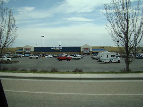
Chris has made the mistake of turning his phone on and he is now obliged to start calling people back. I get out and stand in line to talk to the lady who is checking people in to the Tire & Lube Express. She looks like she would really rather be retired right now instead of checking in people for the Tire & Lube Express at the Wal Mart in Vernal.
"Hey there. My tire is flat. Could you guys fix it?"
"Okay, but it's gonna be about a three hour wait."
"Really? Just to fix a tire? Isn't that like a really quick thing to do?"
"Yeah, but there are a lot of other cars here too. We're pretty busy today."
"Gee, I'd really like to not wait three hours here. I tell you what, I bought this tire new at the Wal Mart in Cortez about a month ago. Could you just sell me an identical tire, this same make and model, really quick, and I'll be on my way?
"Sure, but you're still going to have to wait three hours."
"Why?"
"Well we can't just sell you a new tire that you can right away use. We have to take the rims off your old tire and put them on the new tire, and because there are already these other cars here, you'll have to wait about three hours until the mechanics can get to it."
sigh...
"Okay, well, here's the old tire. If you can fix it, great. If you can't fix it, just put a new tire on the rim and I'll buy a new tire."
"Okay. What's your name?"
And she puts it, and other useful things like Chris' phone number (my battery is almost dead) and the zip code of Moab where I no longer live into her small handheld electronic device, and then gives me a receipt.
It's 12:00 pm.
"So... if they get it fixed in three hours, and nothing else goes wrong, I should be able to get back to Moab just before Midnight, huh?"
"That sounds about right."
Next door to the Wal Mart Vernal has this restaurant called Wingers.
It is basically a TGI Fridays type of deal with a sports bar feel and pictures of airplanes in it. It's right there. We go in for some food, and are pleasantly surpirsed to discover they even have beer! Perhaps my prejudices were too strong. There may be redeeming qualities to this place after all.
I go to the bathroom and splash warm water on my face. Chris sits down and begins interacting with our fabulous waiter.
"...be very selective in ordering and temper your expectations."
The food arrives. We eat. It is actually quite good. I have a burger.
I notice another waiter. He seems to be about 20 years old, and has some kind a metrosexual, "punky" look with some kind of creatively dyed hair color. He seems a bit out of place in Vernal, Utah.
"Hey Chris"
"Yeah?"
"What's up with that waiter guy?"
"That guy right there?"
"Yeah. He looks like he really wants to be punk rock, but like, he is stuck in Vernal Utah. I want to ask him what the hell he is doing here, and maybe tell him there are other places he could live that do not suck as bad."
"He might need someone to tell him that."
"At the same time I want to, part of me also thinks that maybe I shouldn't. I mean, how many people like that do you really think are in this town? He's probably like their cultural vanguard. Maybe I shouldn't encourage him to leave. Vernal might need people like that and they are probably few and far between."
"That's a good point."
I refrain from talking to the waiter.
After we eat we decide, well, we might as well go cruise the strip and see what downtown Vernal has to offer.

I had already been to the dinosaur museum in May. It was really well designed and full of fascinating exhibits. At the time I was living in Vernal for a week and by the end of that week I had concluded that the Vernal dinosaur museum is about the most interesting place to spend time at in Vernal. But I don't get up here that often and I wanted to see if there was anything else I had overlooked.
"Hey, check it out."
"Woah, that place looks open!"
"Hell yeah dude! It is open! That's an open tire repair place! Turn around man, lets go check it out."
"That would be sweet if they could fix your tire in less time that the three hours we have to wait for Wal Mart to *look* at the tire."
"Yeah, and then we wouldn't have to be supporting evil Wal Mart."
"Wal Mart sure is evil."
"Though they are damn convenient. Hey, I think you should pull in here."
"All right man go check it out."
I get out of the truck and go to the office. There are customers inside of it waiting. Alright! I open the door.
"Hello there. I've got a flat tire and I was wondering if you guys could fix it."
"Oh, I'm sorry, we're not open today."
"What? What do you mean you are not open? I just walked in your door and it was open! There's other customers hanging out here!"
"Those aren't other customers, that's my family. They're in town and we're just meeting up here."
"Oh, I see."
"You can try the Wal Mart. They fix tires and I think they are the only place that is open on Sundays."
"Yeah, I know, I already talked to them. I was just hoping I could support some small local business besides Wal Mart."
"Well, not even the mechanics are here, so we can't help you, but you could come back Monday."
"Can't wait that long. Looks like it's Wal Mart. Well, have a nice day."
"You too."
Wal Mart, of course, is evil. The Walton Family amasses billions in profits from an army of over a million workers, most of them barely making above minimum wage and not getting enough hours. The company tends to purchase the most efficiently produced, factory farmed, hormone & antibiotic ridden, ammonia - bleach rinsed, genetically engineered and artificially flavored food it can get its hands on. It has great deals on massive quantities of cheap sugary food-like material that gives people diabetes, weight problems and heart conditions. The "Made in China" part of the Wal Mart supply chain is probably where they got their labor standards from. A visit to any store is guaranteed to be a surreal journey into a dark netherworld of humanity. The degraded and crippled creatures, faces carved downward into permanent frowns, wandering through the aisles, pushing along carts full of unhealthy food and plastic, poorly assembled crap beneath the florescent lights. It is the sad, sad, condition of what Americans have been reduced to.
I would of course have preferred to support some friendly small business that keeps its money in the local economy and pays its workers enough to give them a bit more tolerable quality of life. But if every damn tire shop in the Uinta Basin is going to be closed on Sundays when I am in trouble, well, then screw you local tire shops! I don't want to hear your whining when you close down because everyone went to Wal Mart instead. You put yourselves out of business.
We drive East, down Highway 40, Main Street Vernal Utah.
"Dude, that looks like a bar."
"That looks like a bar that is open on a Sunday in Vernal, Utah."
"I think that's what we need."
"I don't think there's anything else that is going to make this day any more bearable."
"I can't believe there is a bar in Vernal that is open on a Sunday. I thought they'd been made that illegal or something."
"Let's check it out."
Having made an inspection I can say that we approved of the bar in Vernal, though regrettably I have forgotten what the name of it was. It was the bar on the East end of town on the North side of the street. They had many nice Halloween decorations and inexpensive Bud Light beers. They had a friendly drunk guy at the bar who gave us slices of a pizza he had had delivered. This bar came equipped with a pool table, air hockey, and foosball. We were about evenly matched for foosball and air hockey and I even won pool once because Chris screwed it up on the 8 ball. I will say if you ever go there that the foosball is more bang for your buck than air hockey, where the games seems to end frustratingly too soon.
And that's about it.
Finally I got the call.
"We can't fix the tire. But we can put a new one on the rim."
"Okay, just as long as it is the exact same kind of tire."
"Sure thing."
"How long will that be."
"Maybe about half an hour."
"Okay."
The tire is done. It's almost 4pm. We pay our tab and head back to the Wal Mart and pick it up. $70. $70 I could have definitely used. But that day I could have used a tire more. We point the car at Myton and hit the gas. Finally after only one wrong turn we recognize where the road turns to dirt. The sun is starting to dip into a love shade of early evening. After about 15 minutes on the dirt we find ourselves behind a tanker truck as wide as both lanes.

We're worried about passing it because the truck is kicking up so much dust we can't see around it. And he's certainly not about to stop to let us pass. Finally, about the time Chris realizes his dust filter has just taken all it can take, he goes for a pass.
No collision. We pull ahead.
NPR is audible over a weak signal. It turns to static in the dips and comes back again on the hills. The program is talking about big game hunters' efforts to remove coyotes to improve the size of deer herds. I tell Chris about Coal City, off the road just up from Price, where a sign informed me about the Juniper removal program and the planting of grass going on to enable the land to support larger herds of hooved game. Chris shakes his head.
What're those piles?
On the way out we had noticed three large towers, too big to be cairns, standing by themselves on a ridge just off the road. Needing a break and an excuse to stretch our legs we pulled off the road to check them out. One looks like a few of the top rocks have fallen. Chris replaces them with some that were lying around. We're not sure who built these things or what purpose they serve, but they are pretty neat.

Then in the distance, we see the gas truck we had passed coming up the road we had just pulled off of. He hadn't turned. He was coming this way. The calm is shattered. Rather than risk getting stuck behind him again we dash off for the truck and beat him to the road.
Miles pass...
Until at last, a familiar sign tells us that we are finally back to exactly where we started, at 10 am that morning.

The view behind us was beautiful as evening came on.

I changed the tire.
Let's get the hell out of here.
There's two ways. Or actually three, to do this. At this point we are more determined than ever to not get a(nother) flat tire on Wrinkles Road. However, the shortest way to where both of us were going was back down Wrinkles and through Nine Mile Canyon. The first bad alternative involved driving back up how we had just come- through Myton- and then to Vernal, to Dinosaur, CO, through Rangley, down 139 to Loma, and then I-70 to Fruita for me and SW to Moab for Chris. 454 Miles.
The next bad alternative is to, again, drive back up the way we had came, through Myton, West on I-40 through Duschene, South West on 191 to Price, then South East on 191 to Green River, and then to Moab or Fruita. 343 miles.
There is no "good" alternative.
Finally we settled onto chancing Wrinkles Road again. Chris chooses this opportunity to tell me for the first time that he has two cans of "fix-a-flat" in his truck and that if I get another flat I can use one.
To help me out, we took all the gear out of the Subaru and put it into the Colorado. Less weight on my tires pushing them into the shale. Then I went first so I could set a slow pace, and if (heaven forbid) I got a flat, I wouldn't be left behind in the dust.
I drove very, very, slowly.
I turned on my playlist of Quiet, Please, and listened to the series' first episode. Quiet, Please was a sci-fi / horror radio show in the late 1940s, and sometime in 2009 I found out that there was an mp3 archive of most of its episodes online for free download. These are pretty interesting to listen to, and while the plots are of course eerie, it can be comforting to listen to the radio announcers' voice. Whenever I'm worried about getting lost, or the car getting killed by some sketchy road, I like to listen to Quiet, Please. It helps me relax- not too much- but enough to keep the heart rate down.
By the time we get out of the Sand Wash Road and on the Wrinkles Road it is dark. We make it through Wrinkles and head for Nine Mile Canyon. The first turn is easy. Most of the other turns are easy to see but in the dark it's a little harder. You can't make out the full contours of the canyon and you can't always tell what is the main road, what is some side road that is about to dead end, and what is the road you are trying to turn onto.
Finally, several hours later, we make it to Wellington and park at the Chevron. I transfer the stuff back to my car. We go in to get a coffee, say our goodbyes, and part ways. Ted's Place in Green River is closed by now so there's no point in stopping for a last meal. And besides, I spent too much money on that new tire. I make it back to Colorado and to the shop. I unlock the door to a shed, make a little bed for myself out of some rental paco pads, and lie down, shutting the door to a falling rain. Tomorrow I'll unload. Tomorrow I'll change the oil, check the damage on my bank account, do laundry in Ridgeway, and get to Durango. But tonight I am going to sleep. Right now, while the rain pitter patters around me.
* * *
Desolation Canyon is a great river trip. You can avoid most of the Desolation by not doing your own shuttle, or if you do do your own shuttle, don't just do it with "good" tires, or "new" tires. Do it with expensive off road tires. The super high tread, lower highway mile-per-gallon tires that look like snow tires but which you can leave on year 'round. And, if possible, avoid Wrinkles Road.
Shuttle drama aside, a trip down Deso-Gray's takes you through one of the deepest, wildest, and most beautiful canyons on the Colorado Plateau. This is one of the most enjoyable river trips in that region that I have done. The Tavaputs Plateau, Book Cliffs, and Green River Desert are a truly enchanting part of the world. The rapids in Deso are real and fun, but it's not all about the rapids. It's the beauty and the history and the geology and the sheer, remote locale of the place that keeps people coming back. I've obviously done much in the writing of this story to relate various aspects of both the human and natural histories of the area, and I've been able to touch on some ongoing conflicts, issues, and debates surrounding the land, the people, the economy, and the resources of Eastern Utah. In doing so I have but scratched the surface. I decided to write this piece not just to show off a few pictures from a fun trip I took, but to explore and start to answer the many questions I developed about the area before, during, and after my time there. It has been incredibly educational for me to write this, and hopefully you the reader may have learned a few things as well.
As a last note, if you ever do this trip, please do yourself a favor and leave the rafts at home. Self-supported and in duckies is the way this canyon is meant to be run. You'll become a better paddler, and you'll enjoy the rapids a lot more. You'll also have no trouble with rocks at low water.
About a month after the trip, while sitting at a Durango Joe's and typing this story on my laptop, out of curiosity I sent an inquiring email to River Runners’ Transport, one of the companies the BLM lists on their page of shuttle companies. This is what i got back:
Thank you in advance for your interest in services our company offers. The price for a Deso shuttle in 2010 is $200 per vehicle. WE DO NOT DRIVE THE WRINKLES ROAD NOR DO WE TAKE THE 9-MILE CANYON ROAD and your experience is the reason we don’t. We go back to Highway 40, west to Duchesne, and south on 191 to get to Swaseys. The road back to highway 40 can also be difficult, but there is only 25 miles of dirt as opposed to 75 miles on the 9-Mile Canyon Rd. We take a full emergency kit with us and check tires at least three times before we get to Highway 40 so we can catch any problems that may occur as we drive out. The issue with the Sand Wash road is that you can drive 5, 15 or 25 mph but if you drive over the shale, a rock can kick up and slice the tire. We try our best to prevent tire failures but sometimes flat tires are hard to avoid.
Give us a call at 1-800-930-7238 if you have any other questions or concerns.
Thank you again and we hope we can assist you in the future.
For more information on the Desolation Canyon Area, and Utah River Running in General, check out these links:
Desolation Canyon River Information Official BLM Site. Go here to figure out when permits are available, to get your permit, to figure out what you need to bring, to get shuttle information, and to learn about bears in the canyon
Moki Mac River Trips Green River, Utah based Commercial Outfitter that runs Deso
Holiday River Expeditions another Green River, Utah based Commercial Outfitter that runs Deso
Deso River Log From Adventure Bound- points of interest by mileage from Sand Wash.
Colorado Discover Ability Adaptive Outdoor Recreation, great summer rafting program
AIRE Rafts, Catacrafts, gear, and Great Inflatable Kayaks at all price points
Northwest River Supply River store
Down River Equipment River Store based in Denver
Geology / History
Geology Happens Blog
Utah Field House of Natural History State Park Museum (Vernal)
Durango Bill's Page on the Ancient Rivers of the Colorado Plateau
Fossils of the Green River Shale
History of Interstate 70 in Colorado and Utah
* The bug screened huts at Sand Wash are available on a first come first serve basis.
Author's Introduction
Part One: There's a place called...
An idea
Fellow Travelers
Getting a Permit
Logistics
Chris P
Part Two: Happy Canyon
The Shuttle
Sand Wash
Bear Attacks
Desert Bighorn
A 55 Million Year Old Lake
Oil Shale
Rivers That Make Rock
A One-Armed Veteran
Death of a Pool Toy
Petroglyphs
A Hike Discovers Fresh Springs, Salt Springs, a Corpse
Rock Creek
Gumdrop Falls
Rafters
Forest Fire!
A Ghost Ranch
Swimmer in a Rapid
Part Three: Bonus Canyon
Cretaceous Seas, Coarse Grained Sediments, Coal, and Iguanadon
Coal Creek Ruin
A Mild Scramble
Part Four: Desolation
Takeout Day
Tamarisk, an Interstate, and Green River, Utah
Disaster
The Uinta Basin: Armpit of the Desert
Death of a Lake
Wal Mart
Tall Mysterious Rocks
Escape
Links
* * *
I have been unable to write the story of my favorite river trip of the summer for quite some time because someone who was on the trip with me, Chris P, took a month and a half to send me his pictures. It was only once they were finally developed, scanned, emailed, and downloaded into my possession that I could at long last use them as the basis to write this story.
You will be very quick to notice this story does not begin at a put in or end at a take out. It encompasses my learning about the existence of Deso, my planning for it, running the canyon, taking out and returning to "civilization", with of course the last quarter of the story entirely devoted to the quest to replace my tire that was destroyed late at night while driving the shuttle. In addition to numerous trip photographs, discussions of meals, campsites, side hikes, and various tidbits of entertaining dialogue, you will find numerous explanations of much historic, geologic, social and economic phenomena that anyone doing this trip is going to encounter- whether they recognize it or not. My ability to write a story of this length is largely due to the fact that for two and half months I have unemployed, between seasonal jobs, and living in my car in Durango, Coloardo. Thus I had plenty of free time to devote myself to writing, and I was quick to catch on to the fact that the interiors of Durango Joes' coffee shops are a lot warmer that the interior of my car. Especially at night.
I had many questions about this trip that I wanted to solve for myself through research, which writing this gave me the opportunity to conduct. Furthermore, in producing this I have been able to effectively procrastinate from my Ghost Town book for three solid months now.
It is my hope that the approach I have taken will answer a lot of questions you might have about running "Deso" before you plan a trip of your own. I also hope that this article could become a resource for anyone who, in an amateur or professional capacity, finds herself drawn to this part of the world and developing an interest in being able to explain a bit more about what is going on here. It is in everyone's interest that Utah river guides, when asked how the rocks got here, be able to avoid one sentence dismissive "explanations", like, "The rocks are interfingered Wasatch and Green River Formation that was deposited in an ancient lake 50 million years ago." Such phrases are all too commonly encountered by those paying someone to take them down a river and what they don't explain is always infinitely greater than what they do.
I've also tried to keep this article accessible to those who are unfamiliar with the routines of river runners, the geography of Eastern Utah, or the culture of seasonal workers in the desert. I've taken steps to avoid jargon where I can, and I've tried to explain it where it is necessary.
If you find any of this story helpful, if you find some of it inaccurate, or if you are just another seasonally homeless person killing time by hanging on in coffee shops surfing the internet, I'd appreciate any comments being left at the bottom. My generation is no longer paid to write. But peer review and mutual encouragement might keep us going yet.
-LF Dec 17, 2010
Part One: There's a place called...
The existence of a place in the West actually named Desolation Canyon was first brought to my attention in the fall of 2009. The previous summer had been my introduction to river guiding as a marginally compensated "trainee". The season had not been long gone before I was online reading about the Green River, whose Labyrinth Canyon I had had the chance to navigate, twice. In my searching I came across someone's online story about how they had done something called Desolation Canyon of the Green River. It was just upstream of the section I had run, and was even more remote country. And there were bigger rapids. Which is to say there even were rapids. This person I found myself reading about had done their trip in rafts because the rapids would have swamped canoes. I then looked online for pictures. "Deso" seemed to have been appropriately named, the photos that came up appeared barren and foreboding. Reading further, I found this stretch was longer than Labyrinth (84 verses 60 river miles), and at one point it was even deeper (5,500 ft) than the Grand Canyon.
And it was called Desolation Canyon!
I decided I would find a way to do this trip. As of May I still had no boat and no solution to the shuttle issue, but that didn't prevent me from picking up the Belknap Deso guide at Down River Equipment on my last trip for supplies there before moving away from Denver.
If you want to do this trip for 5 to 6 days you are going to be spending about $1,000 per person, before tip, (give or take) to do it with a commercial outfitter. If you are going to do this trip solo you are going to need your own boat and you are going to have to pay someone to drive someone else to Sand Wash, pick up you car, and drive both vehicles to the takeout. You will be paying for their gas and time to do this as well, with the standard going rate at the time of this writing being around $200 per vehicle.
A perk of guiding is that I am allowed to borrow inflatable kayaks ("duckies") from an outfitter I work for on occasion. I am also able to borrow a pump, patch kit, fire pan, and a few cam straps from this outfitter. And a paddle. And a spare paddle. These are really welcome perks. I mean, getting paid would be nice too, but being able to borrow river stuff! Now, that is my kind of business.
With boats secured, it was time to start making plans. When could I do it? It would have to be in the early fall, after the guiding season had winded down. And I would need to find some worthy fellow travelers to do it with. Partly because it's cheaper when we all pitch in for gas, shuttles, and permits together, and also because it might actually be nice to have someone to share the canyon with, maybe even to rescue me if I hurt myself.
Earlier in the summer, I had facebook chatted with Tyson from Denver and I had convinced him that he should come out here and go down a river sometime. Tyson is the guy I met on the Colorado Trail who later helped me get a job where I was a street sweeper and a pressure washer and where I got to go to the minor emergency clinic for four shots and a few stitches on my birthday when I cut my head on the dump truck I was driving. Surely, I owed him a little bit of "Desolation" in return.
Before I started working for the outfitter that lets me borrow duckies I was already working for an outfitter that would let me borrow canoes. Able to make use of them we planned for a trip down Labyrinth Canyon. Another friend of mine from Minneapolis had also expressed interest in coming to visit and doing a river trip, so we planned for two cones and three people. However, when I found I had someone to borrow duckies from (and not just any duckies, but good duckies!) I convinced Tyson to move the trip to Deso instead. He could get a whole week off from work which would give us enough time for the trip and for the shuttle. He was a little nervous about the rapids but I figured he could learn how to deal with them easily enough (I was proved right!).
It's a lucky thing that we moved the trip. On August 19th, an apocalyptic rainstorm bombarded the Canyonlands area. I was doing a trip on the Colorado River that very day and the storm was producing large flash floods and water falls off the cliffs:
Among the many flash floods produced, one particularly remarkable one occurred at a place called Mineral Bottom. Mineral Bottom is the takeout for Labyrinth Canyon. The road there was blasted out of solid rock by a Uranium mining company in the 1950s. This storm destroyed the Mineral Bottom Road, stranding cars and boaters at the takeout, 7 of whom had to be airlifted out by helicopter. As of this writing Labyrinth Canyon is not being run by anyone who is not also planning to run the next hundred plus miles of subsequent Stillwater and Cataract Canyons. The only other alternative also involves running the next fifty miles of Stillwater canyon, but then paying $100 per person to be JetBoated back up the Colorado River from the Confluence with the Green fifty miles to Moab. Either way, it's a hundred miles to the next takeout, and you're looking at class IV-V rapids or paying someone money either way you go.
Once Tyson gave me his dates, and I had convinced him to move the trip to Deso, I started looking online for a Permit. The BLM site lists what days permits are available. You check for days you want, and then you call the Price, Utah BLM office to reserve them. They take your credit card over the phone and send you the permit in the mail.
There's a sentence on the BLM site that says "Reservations are made 5 months in advance to aid in trip planning. " Don't let that make you nervous. It is convenient for the BLM schedulers for you to make a reservation 5 months in advance, but it is perfectly acceptable for you to call them up in the middle of July about a permit in September and get it. If you then call them in mid September to add an extra person onto your trip that is leaving a week later they can email you the new permit instead of snail-mailing it so you won't have to worry about it not being there in time.
The only trouble with this system is that the Price BLM is apparently very understaffed and it is rare that they answer their phone when anyone calls it. They also do not return voicemails. So you have to keep calling, day after day, between the hours of 8 am and noon, Monday through Friday, hoping that eventually you'll get lucky and a human will be there to answer the phone.
Finally, I got in touch with them. They were very informative and helpful, and were able to answer a lot of my questions. I bought the permit.
Over the summer I started drawing up a logistics plan for the trip. Not knowing where any campsites were, I just looked at the map for sandbars and planned a trip for 8 days in about 12 mile increments. A little more or less paddling is easy enough to make up, or squander, the next day.
After that there was the matter of planning food for three people for 8 days. This was a little harder. How long would the ice last? How much propane would we take and how long would that last? At what point do we need the cooler empty so we can put fire ashes into the cooler when we start cooking on fires because we have run out of propane?
I've never done a river trip longer than five days before.
By the time I was doing the actual food shopping I had a pretty intense shopping list, budgeted down to specific quantities of ingredients. The City Market in Fruita had plenty of good food, though like most City Markets, they didn't have the best deals. I probably should have gone to the Wal Mart in Grand Junction instead.
When all was said and done, the cost of this trip was $125 per person. If you included the cost of everyone's gasoline to drive from Denver or Moab it was more like $175-200 per person. That is a pretty good deal. A lot of people can't even keep themselves alive in a city for a week for that little.
The only remaining loose end was just the small matter of my friend from Minneapolis deciding not to return any calls or emails as our launch date got closer and closer. Correctly assuming that they were flaking out, I asked Chris P, of the Moab Hostel and The Dark Crow, if he'd like to come. He said yes. He got excited. I got excited. It was about as axiomatic for him to go down something called Desolation Canyon as it was for me to join and captain his Viking- themed cardboard boat crew to victory in two races in Moab. We made a pretty good team then, and having done Ken's Lake and the Moab Daily section of the Colorado River together several times over the summer in inflatable pool toys and cardboard boats, I felt he was definitely ready to take on an entire 84 mile long canyon. Just look at this guy.
How would you NOT want him on your river trip?
The last bit of planning involved the gnawing unpredictability of exactly what kind of weather we would be facing. It is one thing to find yourself cold and wet on a camping trip you have planned for yourself. It is quiet another to have your own optimistic assurances be the reason why other people are cold and wet. On that day in sunny July when I bought the permit the ranger had assured me that by late September- October, we could get away without wetsuits in Deso. That sounded good at the time. But it didn't stop me from being nervous two months later, sitting in the coffee shop in Grand Junction.
I recently done my first trip through Westwater, a narrow, dark canyon of the Colorado River, where the wind and the shade and the water temperature- no longer steadily rising but now falling- first told me that Summer was ending and the Fall was coming on. On that trip I put on my splash jacket after the first few minor rapids. Unlike all previous trips that summer, where I'd often jump out of a boat for the heck of it to swim around a little bit, on that trip I was actually worried about falling out into the cold, cold water. It was my memory of this trip, and the knowledge that on Deso I'd be taking two friends along, who if they died, I would have to deal with, that prompted me to use my NRS account to put in an order. Besides a new headlamp and a few more cam straps I could use, I ordered the rescue model wetsuit. It's the thickest one NRS sells. Just before Deso, I took it to the lake in Fruita to test it out. It was great. With that and the other wetsuit my river friend Martin had offered to loan me, I felt that if the worst came to the worst, I could put the two friends in Wetsuits, and I'd be okay with a splash jacket and a few layers of wool and poly on my legs.
After all the careful logisticizing, my thoughts eventually drifted over toward wondering at what point the plans would start to go wrong.
No trip leader can avoid thinking about these worst case scenarios, after having done all they can to prepare, but still knowing that they cannot predict everything in advance. Would the weather sour? Would someone get hypothermic? Would someone flip in a rapid and have tied gear down wrong and in that case, what would we loose? Would it be the food? Or the fire pan? Would Tyson figure out the rapids or would he flip and drown? Would we get eaten by bears? Just how "desolate" would we be, marooned on some rock, with no cell phone reception and an evacuation to plan?
Turns out the trip would be for the most part fine, with our only problems cropping up in the form of a flat while running the shuttle the night after the trip was finished. That first picture of me replacing the tire, after traveling 150 miles to buy a new one, will be my enduring memory of the most desolation I have seen all summer. For sure, more desolate than the great salt flats where the skin and throats of California emigrants were burned by alkali dust and unrelenting sun. More desolate than the vertical shafts and mining ruins of Death Canyon. More desolate than the Fish Springs Range. More desolate than El Diente Peak where two people were killed by rocks this summer after I had climbed it without being killed by rocks. More desolate than my sideways run through the right hole in Big Drops Three on the BLESMA trip in Cataract Canyon, or even my recovery and unintended run over Little Niagara in Big Drops Two. More desolate than the Moab Hostel after a certain unnamed resident freaked out and beat up Nicholas and everyone got sketched out and left except for the two creepy unemployed old guys who play chess all day and watch bad TV. More desolate than even backing into the wash in the Dixie National Forest, which I assure you sucked horribly, but had the fortune to occur in a region of ready help capable of fixing the problem on the spot. My Desolation would be the Desolation of the car, in the Uinta Basin, with a flat tire, on a Sunday, about as far away and on bad dirt roads as it is possible to get from a tire repair shop in the lower 48.
The trip started so innocent.
Part Two: Happy Canyon
Wrinkles Road I had heard was the worst damn back road in the state of Utah for flat tires. Infamous to many who run rivers, the road winds its way across a Tavaputs Mesa of Green River Shale to its final, menacing five mile section down Salt Wash- not just a name for a place- but an actual Wash that you drive down. The Wash is graded. But that both hurts as well as helps. A hard, flat, smooth graded road is an easy place for a razor sharp tooth of shale to get stuck in your tire, nowhere to go for it to fall or crumble or be pushed out of the way.
"The issue with the Sand Wash road is that you can drive 5, 15 or 25 mph but if you drive over the shale, a rock can kick up and slice the tire. "
I had heard horror stories.
Just before leaving to explore the Ghost Towns ( 1, 2 ), I was amid some beer drinking festivities at Arland and Chris' house in Moab. They have this kind of friendly drunken farmer for a neighbor who laughs a lot when you say funny things around him. Or anything around him. That evening Chris and I were throughly educated as to this guy's opinion of the Sand Wash Road, as it existed years ago when he last did Deso. Driving there in a truck, the road was for him no problem. That made me feel a little bit better but I was still of course not willing to trust this guy's opinion.
Time passed. I rushed through my ghost towns. It was time to start getting ready.
I finished assembling gear the day before we were to meet up. I spent a few hours at the sheds , making sure we got equipment in good condition, boats with few scratches and intact carrying handles, enough cam straps, a patch kit... I put everything into piles on the pavement before loading it into the vehicle and double checked the permit one last time to make sure I didn't forget anything.
The next morning in Fruita I did the shopping and was hanging out in the parking lot repackaging everything when Tyson showed up. A few minutes later, we had consolidated our cooking gear into just what we'd need for the trip. Once it and the food were thrown in dry bags, we were on our way to Green River to meet Chris and drop cars off at the takeout, Swaseys' Rapid. We got there about 50 minutes late. But we didn't wind up needing anything on the river itself that I hadn't thought to pack (or have Chris or Tyson bring), with the possible exception of a grappling hook that would have been convenient. In my book a record like that on a private trip is an acceptable enough reason to be late.
At Swaseys' we got into Chris' truck, which is a 2005 Chevy Colorado with a cab and a nice topper. I folded myself up into the cab for the first leg of the journey, North on Highway 6/191 to Wellington.
This incredibly scenic stretch of state highway is bordered on the right by steeply eroded "Book Cliffs" of stream deposited Cretaceous sandstone. On the left is the San Rafael "Reef" of petrified sand dunes dating from the Jurassic. Sandwiched between the two in space as well as time is a highway paved over Mancos Shale, once the bed of an ancient sea, now uplifted to 4,500 feet and containing abundant clam fossils. The Good Lord, indeed, must have been as busy as he was indecisive on that Third Day.
At Welligton, I switched places with Tyson to help navigate. We headed into the cliffs, past a coal mine, and towards Nine Mile Canyon.
The road was well marked, and we had no problems finding our way or getting lost. I knew before the trip that Nine Mile Canyon is famous for its petroglyphs, but being so focused on just making the trip possible I didn't study up on "interp" as much as I would have if this was a commercial trip. Nonetheless, we saw a few examples of the Ute and Fremont cliff etchings along the way, and we stopped, pondered, and examined.
We got to the put in just as evening was coming on and our desire to explore was tempered by a need to slip into something more insulated than T shirts. We walked around, checked out the place, and discovered the ranger was out for a hike and that we wouldn't be able to check in with him until tomorrow. This we learned from another group of friendly river runners that we'd be running into off and on throughout the trip. We admired an old historic cabin, and some newer bug screened huts* we hadn't reserved before settling on the number 2 campsite, behind the shitters.
You can't smell the shitters in this photo, but they are there, just out of the frame off to the left. And I tell you there is no smell of desert river running in Utah quite like the smell of a BLM shitter. This campsite didn't smell as bad as the other one, but...
There at least were no bugs! Nor commercial launches, nor threats of heat stroke. I must say, this end of September is really a great time to run rivers. Water is down, no bugs, no crowds, things are nice...
Chris P made us one of his trademark steak dinners that night. We also took a moment, er, rather... a few moments, to assess and confirm the quality of our liquor supply. As we were doing this trip with smaller craft, space was at a premium. We settled for more concentrated stuff as opposed to beer. We had a nalgene of Sky Vodka, a nalgene of unidentified Rum, a handle of Ancient Age Bourbon, and a handle of Sauza Blanco tequila. Feeling the cool air and looking at our warm drink provisions, we settled on the cocktail whose potential would be thoroughly explored and exploited over the next 8 nights: hot chocolate with booze.
Chris is a Park Ranger Academy graduate. He likes camp fires and he likes them big. For most of the trip we had to have smaller ones as our fire pan is a thing of finite proportions, and because we were packing out the ashes in accordance with leave no trace ethics (as well as BLM regulations). But this first night he had a large fixed campfire ring to work with, and he was in his element, with characteristic armbound headlamp, making a large cooking fire.
We had many potatoes, so we fried them up as a side to the steak with oil, salt, and rosemary, in Tyson's lovely cast iron pan that cost $40.
That pan is what we took to cook with, and it would over the next 7 days become something of a source of tension within our group. Chris P, who was a former fancy chef, and myself who is a former fancy waiter as well as professional river chef, made clear on several occasions our desire to wash the pan, so that it would not emit a bear attracting smell while we slept. We offered to re-season it immediately after we washed it so it would not rust. Tyson, however, was adamant in his refusal to let this happen. The pan was clearly his piece of equipment, which he was going to take care of, and until he drowned in a rapid or was eaten by a bear himself, there was going to be nothing we could do about that.
Here are a few links to stories about bear attacks late season (when bears are hungry and stocking up on fat for the winter) in Desolation Canyon:
http://www.deseretnews.com/article/705336739/Desolation-Canyon-bear-attacks-may-be-linked-to-drought.html
http://www.deseretnews.com/article/995595/Bear-attack-prompts-warning.html
http://www.ksl.com/?nid=148&sid=7717153
http://www.blm.gov/ut/st/en/fo/price/recreation/riverinf/bears.html
Coming to grips with this state of affairs I decided to allow Chris and Tyson to pitch their tents each evening where ever they liked. I then just slept on my thermarest or in my duckie just a few feet from the river, with the bear spray out and next to me. Thataway, a bear would first smell and have to eat through either Chris or Tyson before it got to me, and I'd likely be awakened by their screams in time to act heroically or run away, depending of course on the situation.
Fortunately, no bears were seen or felt by our group on this trip.
Though I still think he should have let us wash that pan.
This is what it looks like where Sand Wash empties into the Green River, constricting the channel, though it is still wide enough and the gradient is still gentle enough so as not to cause a rapid:
A "wash" is like a gully or ravine. It is usually dry. But on those rare occasions when it rains in the desert, washes, often draining a large area, can fill up quickly and become raging torrents, eroding their banks, carving deep gullies, and pushing large boulders over one another along their bottoms, the sound of which you can hear should you ever be "lucky" enough to witness a wash in flash flood.
Washes can be extremely dangerous. They can eat roads. This is what my car looked like when it fell into a wash that was eating a road in the Dixie National Forest. It took myself, an old man, three rednecks, two tow trucks, a pickup trick, a z drag, $250 and a whole day to get that thing out of there.
Luckily, it didn't rain and our time at Sand Wash was rather peaceful.
Here we are on Day One, Sept 26th, unloading the truck and pumping up the duckies:
Loading the duckies:
Notice the sunshine. It would be sunny for our entire trip, the day before, and the day after. Three days before the trip, a torrential downpour (1, 2, 3) caused flooding throughout the area. The night our shuttle was completed, the rains returned again. We were very lucky!
Things get tied in with cam straps, which are a great invention. It's important to be able to start with a lot of them, though as days go by and you repack each morning, you learn how to become more efficient and you tend to acquire extra straps, which you can then use for bow and stern lines.
As we set off paddling Chris P announced that he had brought along the lawn chair. If only I had known! I would have brought along the Dirty Dog! The lawn chair (with cupholder!) and the Dirty Dog are both $11 inflatable pool toys we bought at Walker Drug in Moab. I did the "Moab Daily" in the dog three times (once at 20,000 cfs and once at peak snowmelt of 30,000!) and Chris did it in the lawn chair at least twice. Well, the lawn chair is a more relaxing ride anyway, and after fixing a leak with duct tape I paddled it for a while. As days one and two were basically still water, we took these with no hurry, enjoying the relaxation of finally being on the water.
We passed "Little Horse Bottom" and saw wild horses who had come down to drink the river. They actually looked a lot like Mark Peesel's picture of a wild horse that's in the guidebook. About this time we passed through our first named bit of aquatic turbulence: "Tabyago Rifle." There were no casualties.
Chris on his vessel
I make my dry bag into a pretty comfortable back rest
The walls began rising pretty steep pretty fast, with deep alcoves and "amphitheaters" carved by erosion.
Late in the afternoon we found a small sandbar and camped out on it.
One of the many advantages of doing light, self supported duckie trips (still far more luxurious than backpacking) is that with a small group like ours you can camp pretty much anywhere. This came in very handy for us, as in the planning stage I had opted not to spend the extra $30 to be able to camp (or set foot) on the left side of the river- which is part of the Ute Reservation and which has a separate usage fee in addition to the already mandatory BLM fee. That afternoon we passed at least one marvelous looking sandbar river left- the first of many such great looking campsites we would pass and not camp on. When I do this trip again I am definitely picking up the Ute permit. Being able to pull over at the next best place is a pretty nice convenience to have when you are tired from a long day of paddling and the sun is going down over the rim and temperatures are starting to drop.
That evening we had steak and couscous.
The next day was more still water, with a few riffles, and two or three rather unintimidating rapids. Deso isn't just a great trip because it of its name, or because of its remoteness, or because of its rapids... but the whole canyon from Sand Wash to Green River couldn't have been built better if you were trying to design a place to teach someone white water river running. This is what Bill Belknap- the guy who wrote several popular waterproof guide books- used to do professionally. He founded a company called Fastwater Expeditions that took people who hadn't been in rivers before down Deso in "sport yaks"- 7 foot plastic dinghies rowed with oars. You start with two days of riffles to get used to the wilderness, and to learn to maneuver your craft amid faster moving water. Then on day three you're hit with a few actual rapids. They eventually grow in size until you're ready to run Three Fords, about the "biggest" rapid at this water level.
The University of Northern Arizona has a fascinating online exhibit on the life and photographs of Bill Belknap. Few boaters using his guides today probably know one of Bills first jobs was as a publicist for Boulder Dam, that he accompanied Roosevelt to Potsdam as a photographer, or that his highest level of completed education was the 8th grade.
None of the rapids in Desolation Canyon posed any great technical challenges. A few rapids had rocks to dodge in them, but this was fairly easy to do. Cow Swim was probably the "hardest" in that you had to turn to the right mid way through the rapid so as not to hit the steeply cut wall river left, but even this was pretty easy. Square up to waves and holes, avoid the rocks, and follow the "tongue" on everything and you'll be fine in Desolation Canyon.
By no means, though, should you interpret this to be me saying that the rapids are not exciting. For in several: Lower Wildhorse, Chandler Falls, Surprise Rapid, Cow Swim, Three Fords, and Coal Creek, to name but a few, you get some bounce!
The morning of this second day we slept in pretty late, and in doing so set for ourselves a comfortable pattern for the rest of the trip. In the morning we'd be passed by groups of early risers while we ate breakfast. Eventually we'd catch up and pass these groups- often already at their campsites- later in the afternoon. With the folks we met at Sand Wash we wound up frequently stopping to trade some liquor for a few river beers to finish our day on the river.
I definitely appreciated finally being able to sleep in late, and to not have to set my alarm for 5:30 am to wake up in the cold, pack all my gear, and rush to make breakfast for 25 people!
After breakfast on "morning" 2, in a bit of calm, deep water just off our sandbar, we conducted our first flip drills. I wanted to be sure everyone could manage to get back on top of their over turned boat, flip it back over, and then get back in, before we got into any of the bigger class three rapids. Tyson and Chris got the hang of this pretty quick, and even figured out some ways of using their knees to flip the boats back over that seemed to work a little faster than what I was doing.
We continued down the canyon.
Suddenly, river right and downstream, we spotted a herd of Desert Bighorn Sheep. Desert Bighorn are a lot like the regular Rocky Mountain Bighorn, but they have adapted to a harsher environment and can go longer without water. Tyson got his camera out and maneuvered his craft so as to glide right by the sheep. In time he was closer and closer and had still not taken his picture. We were basically shouting at him by this point to take the damn picture already before the sheep got scared and ran away, and he continued to hesitate. Finally, he got some great shots, very up close. The sheep finally wandered a bit, but hardly "ran".
We ate lunch while floating this second day, an innovation we would continue throughout the trip. In an easily accessible "rocket box" were bagels, peanut butter, pretzels, chocolate rations, gold fish crackers, tangerines, oranges, and pringles. These were kept upright and accessible with only having to remove one cam strap to get the lid off.
Shortly after lunch, while I was standing on my boat and looking down stream, it occurred to Chris that a bit of a laugh could be had at my expense by stealthily paddling his vessel up to mine and then at the last minute using his paddle as a ram to push me off. Before I knew what had happened I was toppling into the silty, foreboding embrace of the Green River.
Though I was a good sport about this it would be inaccurate to say that I held no grudges. The sun had gone down and it was a little late in the day to be soaked.
Downstream was a little bar. What was it like? I got out and approached
Mud.
Yes. Mud. Just a few inches of mud.
Wait.
On the downstream end of the sandbar actual sand is deposited over the mud, and the whole bar is about a foot above river level, with just enough space for our kitchen and a few tents. We made camp.
You can see in this picture how the geology is already changing. When we started the canyon walls were gray. Here they are mostly brown. On an aesthetic level I appreciated the beauty but on a geologic level I was perplexed.
I knew there were two types of rocks in the canyon.The Green River Formation and the Wasatch Formation. But which was which? I knew from stratigraphy I had studied that the Wasatch Formation was older (deposited first) than the Green River Formation. But I had also heard that the two formations are "interfingered". If you look back to the photo of our campsite on night one, you can clearly see two interfingered formations. The gray formation from the first day was dominant, but by now it has clearly given way. The walls are now generally brown-orange sandstone, though I can still see thin gray seams of another formation (gray shale and mudstone) horizontally deposited between different brown-orange layers.
What is going on here?
The Belknap guides can be handy in a pinch, but they have their limitations. For example, on day one we admired the interesting picture of the historic "iron prowed skiff" the guide said was below "Gold Hole." However, the guide then lists two different places called "Gold Hole" (between miles 89-88, and again between miles 82-81). So which was the skiff beneath? Needless to say, we never found it.
The geology section in the back of the Belknap guide is pretty helpful, but it and the trip left me with more questions than answers. I would have to do more research, and I have taken the time to do this in the hopes that someone reading the article will leave it being less confused about geology than I have been after reading most Desolation Canyon trip reports.
The story begins about 55-44 million years ago, in the period of geologic history referred to as the Eocene, when Utah looked very different. Where today there are the high and dry wastes of the Uinta Basin, there was once a great lake: Lake Green River. This lake's history has been recorded in several different geologic formations. The exact borders and boundaries of this lake are difficult to pin down for sure because so much of the southern boundary has been eroded away. But, we can tell that this lake extended over the Uinta Basin, and around the Uinta Mountains into Northwest Colorado and South West Wyoming. It would have looked something like this:
The black line on the map above represents the present-day location of Desolation Canyon.
The Wyoming section of this ancient lake is referred to as "Lake Gosiute." The Uinta Basin part of this lake is referred to as "Lake Uinta." It is unclear whether these lakes were one giant lake or were separated by land, connected perhaps only by streams. What is important, however, is that where these lakes once stood there is now over 4,000 feet of rock- a fossiliferous, carbon rich depositional record of life.
In the days of Lake Uinta, Utah was a much warmer place. As I am writing these words the temperature this week in Desolation Canyon will be 20 degrees at night and snowing. But 50 million years ago the climate was warm enough to support the existence of crocodiles, whose fossils are found in the Green River Formation, Lake Uinta's ancient lake bottom. The higher temperatures appreciated by the crocodiles were a condition of the earth's actual climate at the time, and not because of a more southerly location of the North American Plate, for the plate then was not at a much different latitude than it is at today.
The crocodiles were not alone, for the fish they preyed on are also well preserved and their fossils have been known to science since the 1840s. The grains of sediment in the lake bed were so fine that they were even able to preserve leaves and insects. A trip to the Utah Field House of Natural History State Park / Museum in Vernal will reward the historically curious with a very large collection of these specimens.
A few examples:
It is thought that the lake must have been very deep and stagnant, with low oxygen levels near its bottom which kept scavengers away and allowed the fossils to form.
Green River Shale has also been in the news because of its rich energy deposits. Lots of oil is found in the shale, and is drilled for enthusiastically through the Unita Basin. Oil shale as well has been found in the Green River Formation in tremendous quantities. On any river trip along the Colorado River it is common to find pieces of this shale that has been carried down by erosion. It appears flat and white, river-rounded into thick "pancakes." You can break it open to expose the black interior and immediately the smell of oil is released. You can even light this rock on fire, a fact that must have been discovered for the first time by a very unfortunate homesteader, stoking up a warm fire in a chimney he built of this flat, convenient rock for his log cabin.
No one knows for sure how much oil shale there actually is but it is estimated that there is about 213 billion tons of the rock spread across the borders of Utah, Colorado, and Wyoming. These deposits represent about one half of global oil shale reserves. The Uinta Basin is estimated by the USGS to contain about 1.3 trillion barrels of oil-like kerogen, with another 1.5 trillion barrels are estimated to be in even higher quality ore in Colorado's neighboring Piceance Basin. Currently our country consumes about 20 million barrels per day of oil, and the satisfaction of this demand has hitherto plunged us into all kinds of unpleasant and expensive relations with foreign countries. So, you might ask, why not mine the stuff, and achieve "energy independence" for the next few hundred years?
There are currently several experimental sites oil companies have leased from the BLM on the Roan Plateau in Colorado where they are attempting to devise ways to economically extract liquid oil from oil shale. There are many reasons why this is a difficult process. Methods currently being experimented with require the underground application of intense heat to the shale- a very energy and water-intensive process that itself consumes much of the energy you are trying to extract in the first place. So far it is cheaper to buy pumped liquid oil than it is to do this.
Let's say cost was not an issue, and we were so desperate to get out of the Middle East that ultra- nationalists were voted into office with a mandate to subsidize oil shale development. To do this with present technology would take enormous quantities of water in an area where water is scarce. And there would still be serious concerns about air and water pollution that could effect everyone dependent on the Colorado River as a drinking source.
For now much of the oil shale is classified as a "strategic reserve" that no one really knows what to do with.
Talking about so much rock having been transformed into oil shale, and so much more of the Green River formation that is not oil shale but ordinary shale and mudstone, you might be wondering, where did all the mountains of sediment come from that filled in this lake? That question is the key to understanding Lake Uinta and the Wasatch- Green River "interfingering".
Of course some of the sediments that filled this lake were carried there from the southern slopes of the Uinta Mountains. But the Uintas alone did not supply all the sediment. To understand where all of it came from, you have to understand that during this time, the ancient river systems of the Colorado Plateau drained to the north, in an opposite direction to the way they flow today. This condition continued until only about 25 million years ago, when uplifts in Colorado and Wyoming changed river patterns.
The land around the lake was very, very flat. This allowed lake levels in high water years to expand across great geographic distances very quickly, rolling over the various sandy deltas of stream deposited sediment and then burying them beneath the fine grained muck and ooze of stagnant lake bottom- dirt, mud, dead aquatic animals, plankton, decomposing leaves and plants. Soon enough these lacustrine (lake-deposited) sediments would be buried beneath the sands carried by North- flowing tributaries. The lake level could for a time retreat, though only for a while before the process repeated itself.
A great way to appreciate just how much sediment was flowing to the north is to take a trip down Cataract Canyon of the Colorado River. The lower half of Cataract has been flooded by Lake Powell, whose waters conceal the former locations of over half the canyon's rapids. On the last day of your trip, you are basically paddling (or motoring) through Lake Powell. But on each side of you you do not see just a rock canyon. No. You see high walls of sand, the "Powell Formation"- sediment that was carried by the river and deposited here at the mouth of the lake during its high water years. Here is a picture from a trip in August of these sediments opposite our campsite just below the rapids:
To appreciate the scale, and the varieties in thickness different flows and sediment loads in different years can carry, here is the present author examining this "formation" and providing himself a human figure to scale:
All that sand was laid down in less than two decades. It extends for miles on both sides of the river as well as under it and far into lake Powell. And that is only sand from the Colorado's upper basin- the Green, the Yampa, the Gunnison, Dolores, and the Colorado itself. Lake Uinta was the recipient of this sand for millions of years, and not just from these ancestral rivers- for the ancient San Juan and Little Colorado drainages were at this time flowing to the North as well!
The Colton Member of the Wastach Formation is the name given to the sandstone deposits ancient streams once carried Northward into Lake Uintah. It is this formation that you see thin, red-orange layers of at the end of your first day. It is this formation that comes to dominate the canyon as you get deeper into it. You're passing through an ancient river delta.
Finally, in early Miocene time, about 23 million years ago, the Tavaputs Plateau was just beginning its uplift. The Yampa river was then still a powerful tributary flowing from East to West into the silted up former lake. It began cutting desolation canyon to the South. The fact that Desolation Canyon can exist at all is because the river cut downward faster than the rock it was cutting was rising. About this time, the Wind River Mountains in Wyoming began to uplift again causing the Green River to turn South and join the Yampa.
Though we commonly refer to the Yampa as a tributary of the Green, if you examine these rivers as they were formed historically, the Yampa was there first, and the Green is really a tributary of it!
* * *
That second night, while wondering and not knowing exactly what was going on with the changing rocks around us, we dined upon soup with a side of bagel, as we would for several nights to come. The cool nights of late season are wonderful for soup.
Bagels are always a nice compliment, and they fill you up in a way that helps to stretch a limited quantity of soup into seconds and thirds for hungry paddlers.
After dinner we baited lines with bits of meat, and later, fish innards, in an attempt to catch the elusive and alleged Green River Alpha Cat
Unfortunately, though we did catch many catfish, they were all small, a foot long or less. Hardly worth the effort for a meal to deal with such a slippery, spiny creature. We knew, surely, that true Alpha Cats must exist somewhere down there. But catching them was another matter. Though we had brought plenty of cooking oil, and even a fish basket in anticipation of having a fish dinner one night, this was never to be.
In less than an hour we had abandoned the futility of our fishing luck and opted to retire to our own respective liquors. We admired the stars and searched in vain for constellations we could identify within that tiny sliver of sky we could see between the canyon walls. The summer stars were turning, the winter ones were not yet out. From time to time we consulted the star chart, before finally deciding the stars looked good no matter what they are called. We sat back and conversed, drifted to politics, social issues, families, and back again. From the trivial to the serious. Big issue conversations on the river are curious things. The environment is relaxed enough, and the presence of bears and rapids and other forms of potential death is able to instill a sense of comradery deep enough, that even representatives of a culture as adverse to meaningful political conversation as ours find themselves asking questions and stating views with a frankness rarely present in more "civilized" environments. With all their distractions. But here... with these canyon walls and sandstone rocks, a flood plain that 50 million years ago was formed from other eroded sandstones that themselves had already been laid down long before the Dinosaurs. Nature silently listened, in stoic wonder, as three young members of this new, stumbling species struggle to define the "proper" way to legislate their own emotional and reproductive exuberance... while vacationing paleontologists fail to applaud, condemn, or even notice the sexual preferences of those ungainly, early mammals whose entire species' cultural development had been reduced to a few disorganized bones sticking out of a crumbling rock wall twenty million years before the fist monkey walked upright...
I participate, fully, in the ensuing discussion. Not so annoyed to be reminded of "politics" this far from organized humanity as I am invigorated by my surroundings.
"As much as I love listening to this... I need to tell you that my mother is a lesbian, and she raised me herself. She was an active parent in our Boy Scouts and when she came out they kicked us out. Are you saying you there is something wrong with me because I was raised by a gay parent?"
* * *
The next morning we were treated to a fantastic view of what Desolation has to offer. This picture was taken from our sandbar just upstream from Lighthouse Rock, which is the distant phallic object river right. The red cliffs are the dominant (Colton Member of the) Wasatch Formation, the seams of Green River Formation are quite thin and difficult to see in this photo.
Such a beautiful morning, and our trip so far unimpeded by serious injury, deprivation, or death. Seeing quite little we could at all seriously describe as "desolate", we began to doubt the name bestowed upon the environs. Is it truly deserving of so lovely a place? Ah, but it was not the pioneer who had inflatable rafts, 10 lb blocks of ice, chicken apple sausage and Hawaiian Hazelnut in the morning. The canyon, here, was dubbed thus Desolate in 1869 by the exploratory crew of famed geologist and one- armed civil war veteran John Wesley Powell. Not the first white man to travel this section of the Green, Powell was the first white man to travel this section of the Green who was also a trained geologist with a specific license to replace white space on a map with contours, boundaries, features, and names. Though today you may at times doubt the justice of his assessments, it is impossible not to admire the poetic and literary value ("Gates of Lodore", "Dellenbaugh Buttes") of that expedition's command of the English language.
Having personally paddled or rowed across much of their route along the Green and Colorado Rivers, I can't help but wonder if many of the names given to places by this party (Dark Canyon, Disaster Falls, Hell's Half Mile, Lucifer Rock, Satan's Gut, Desolation Canyon, Dirty Devil River, etc...) really tell you more about the preparedness, attitude, and boating skills of those early river runners themselves than they do true justice to the natural aquatic and geological features that they "describe."
Today we thought of a new, more appropriate name: "Happy Canyon." I'll introduce it here. Let's see if it sticks.
Day three had a bit more of what could be considered class two rapids. We camped out on a small sandbar island, river right just below Firewater Rapid.
It was infested with large wolf spiders.
It was here that Chris pointed out to me, "Hey, if you are sleeping out in the open anyways, why don't you just sleep in your duckie, rather than on your thermarest that isn't as soft as a duckie?"
That was a pretty good idea. Duckies are soft, and nice
In the days to come I'd learn a few more duckie sleeping tricks, like deflating the floor a bit more so it's "flatter" and more comfortable, and putting my thermarest in the duckie as well to provide an extra layer of insulated air.
While Chris and Tyson set up their tents, I decided to try out my wetsuit, neoprene gloves, and neoprene socks for how well they'd hold up when the sun went down. Suiting up, I put on my helmet and took the pool chair above the last riffles of Firewater that we were camped below.
The suit was great, I was warm and comfortable.
The current was swift.
As I jumped in, disaster struck. The arm rest detached from the body of the lawn chair, which then instantly filled with water and sunk. Yet the headrest compartment was perfectly intact and retaining air. So instead of luxuriously relaxing on this thing, I found myself swimming the rapid with a liability of sinking plastic wrapped around me. I couldn't let it go. That would be littering, which is greatly frowned upon by the Bureau of Land Management and wilderness ethicists. So I held on and swam it out as best I could.
The next day, day four, we ran a few fun and unintimidating rapids. Along the way, we stopped to look at some Petroglyphs. I know there are a lot of them in the canyon, but I didn't know where they all were. These are the ones marked prominently in the Belknap guide at mile 63.
Very little is known about the authors of these inscriptions, except that they were pecked by Fremont Indians, who inhabited the region until sometime around 1200 CE. They did not leave behind the same large cities as did the Ancestral Pueblos (Anasazi), who lived further to the South. With less archeological evidence it is harder to speculate about their lifestyles, other than that they combined hunting and gathering with the cultivation of corn. The images of some animals, such as bighorn sheep, deer, and bear tracks are fairly obvious. But are these reverential images of worship? The story of a successful hunt? Were they intended to communicate some important message, or are they simply "art for art's sake?" Many books exist which endlessly speculate about the meaning behind various strange symbols, but no one really knows for sure.
One fact I think I have learned from studying many Fremont and Anasazi Petrogylphs is that most of them must have been pecked into the earth by men, due to the prominence of phalluses among several. Here's a great example, from a slab of Wingate Sandstone near Moab:
Paddling along we found the canyon opened up beautifully. This was just above Fretwater Falls about mile 59.5. The side canyons were epic. We decided to make camp and explore them the next day.
When I woke up Chris was cooking the breakfast sausages and toasting the bagels. I can't tell you as a guide what a treat it is to just sleep in and let someone else do the cooking!
We put on boots and started our hike. Of the two side canyons we had camped near, we decided to explore the lower, forked canyon.
We found remnants of deceased herbivore.
It looked well picked over by scavengers.
Exploring two forks of a side canyon, several times we saw "routes" from afar that looked feasible. Clearly, this looks pretty easy to climb, right?
Yet each time, though we made some progress, it was always stopped by about a 15-20 foot layer of near vertical cliff forming sandstone. Twice we saw "ways" it could be climbed, but at each of these places the sketch factor was too strong. It was too steep, the rock was too crumbly, the exposure was too high, and definitive medical care was very far away. So we retreated.
As a side note, up these canyons we did find natural springs dripping in two places, and natural salty springs dripping in another. The locations of natural springs are pretty good to know about when you are in the desert. I marked them on my map.
Here is Chris washing himself off amid the dripping waters of a spring. He looks like he is having a pretty good time.
Maybe he was dancing?
Here is me hiking out of the side canyon back towards the boats. My hat is a little floppy and I'm slightly disappointed that we didn't summit. But. I'll be back. Next time we'll have grappling hooks.
Tyson looked like this.
Getting back on the river, we had a blast in Lower Wildhorse and Surprise Rapids. Next time I'll have to plan to camp at one of these, though our hike was pretty nice and I don't regret doing it.
We stopped to get water at Rock Creek, one of the few places in the canyon where springs or streams provide the traveler with "fresh", non-silty water.
At this point in the trip, the unseen top walls of the canyon are 5,390 ft above the river- deeper than the Grand Canyon is at Bright Angel Trail.
There is rock art here as well but we didn't know about it at the time. We didn't fish for alleged rock creek trout either. Maybe next time?
We had brought along 3x 6 gallon water jugs, as well as personal water bottles and 2x 1 gallon MSR reservoirs that are convenient to have during the day. At this point in the trip we still had an entire 6 gallon jug we hadn't touched yet, though the other two were empty. Not sure which method would taste worse, we treated the water in one jug with iodine, and in the other we used bleach. I'm not sure we were able to figure out which we preferred. The iodine tasted better (we added the other pills you use to make it drinkable after the bacteria and protozoans are killed off), but it had an aesthetically disturbing cloudy appearance. The bleach water at least looked clear, but the smell and taste was bad. Perhaps more of the bleach would have disappeared if we left this water jug open at night? Maybe. Bleach does break down naturally after all. Ahh... but the threat of inextractable floating moths or spiders down in the jug the next morning was too much to bear. We kept it shut tight.
Whatever the appearance or taste, at least no one got sick.
Below Rock Creek the canyon opened with deep side canyons on river right. After visiting briefly the other rafting party's far superior camping site below the creek- complete with big healthy cottonwood shade trees and plenty of flat, sandy surfaces- and there exchanging tequila for PBR, we continued on to the mouth of Snap Canyon, where we found a few rocks with mud and sand for our own campsite.
We played frisbee there, among the cactus and the antlers.
The antlers we found were quite large and from an elk. We were now deep in the heart of the wilderness.
Soup and bagels again. By this point in the expedition it was speculated that the sodium in regular cans of black beans was having an adverse effect on the digestive tract of one of our participants. Though black beans in soup is one of my favorite ingredients, I grudgingly went along and moderated their use for the next several nights.
The author cooking on the river.
The headlamp is the Princeton model that is sold by NRS. Very bright and highly effective.
We woke up to day six. A great rapid day. We had no problems, just read and ran and followed the "tongue" on everything. Mostly. Oh yes, one or two rapids had some rocks in them. Don't hit the rocks. And if you hit a rock, lean into it and then bounce off, so your boat doesn't get "wrapped" on it and flip. Though none of us had this problem. I don't think we hardly hit any at all, even.
Finally, we got to the rapid we had been anticipating for a while. Joe Hutch, or "Cow Swim" rapid, so named because its location used to be that of an easy ford for ranchers back in the day, before a flash flood occurred that turned it into a rapid. How my mind had been intrigued by this place, ever since I first heard Sara's description of duckie-ing it that highwater day this summer back at the hostel. Not the "biggest" rapid on the river (that honor would probably go to Three Fords Rapid), it was the only one we felt compelled to scout. There's a horizon line which is always ominous, as well as a turn to the right that might require some thinking to accomplish.
And there was another reason.
Our boats are light, fun, capable craft. I had wanted to find a fun rapid to camp above the whole trip, so we could run it over and over. Here was such a rapid. And at the scouting point, on river right, was just a tiny enough sandbar, and a lot of somewhat horizontal ish rocks, that we were able to improvise a campsite. Finally, we could run a great rapid. Over and Over. Until we were blue in the face!
Flip drills! Great time to practice:
I had put on my wet suit because I wanted to spend a lot of time running this rapid, I was probably going to get wet, and it was getting late.
The rapid looks a lot bigger when you are in it than when you are taking pictures of it from the shore. That is because it is bigger when you are in it!
The first drop is awesome.
Woohooo!
I had some good lines :)
I even ran it backwards. Like a champ!
Chris approaching the rapid
Chris in the first drop
Yer Doin It!
Where's Tyson? There he is!
Tyson's Doin It!
A rather uncoordinated tandem paddle that miraculously did not result in a flip
Carrying the boats back up to do it again
Holy shit Chris, how did you not flip?
Sideways in a hole. That was pretty sweet. These boats are Tributary Tomcat Tandems, and they are great, very capable things in whitewater. They can also carry a heavy, multi day load and they track decently in flat water. Did I mention they look pretty good and are comfortable? Or that they have numerous handy tie-down loops for gear? Or that they self-bail relatively fast? I endorse these boats, and my review of their performance on this trip is even printed on AIRE's site!
I ran Cow Swim many times, I think 8 total. On the last two I flipped both times, though to be fair, I was sitting dangerously far back in the boat in an attempt to make the run more exciting the first time, and the second time, I flipped when I tried to surf the hole that Chris, above, is sideways in. I flipped once with a straw hat on, and once with a helmet on. Both times I was able to get back on the boat okay, re-flip, and finish the rapid right side up. The second time I flipped, while climbing on, I kicked a rock. Not enough to hurt or anything, but enough to remind me that rapids are serious things- there are rocks down there than can mess you up!
If you are going to flip in a rapid it is a better idea to flip with a helmet on.
Otherwise you might wind up like this... and not to be found for years to come!
Cow Swim Rapid.
Gumdrop Falls.
Right next to the Licorice Forrest.
Below the rapid evening light was turning the canyon to a beautiful panorama.
You can just see in the right of that photo the other group of river runners that we were passing each day and getting beers from. Today they passed us, and got a much nicer campsite BELOW the rapid. What an idea!
They were pretty cool people.
Here they are coming in above the rapid where our "campsite" was, so they could scout it:
They had some pretty nice old school hypalon bucket boats from the early 80s. I didn't know they had hypalon back then. Over the course of interacting with this party we were educated as to the many oft-forgotten advantages of bucket boats, which I recall are, in descending order
1) It's a boat you already have and don't have to buy because you bought it 20 years ago
2) When it fills up with water in a rapid in the Grand Canyon you no longer have to worry about flipping because it has so much weight it will punch through anything
3) They track better because their bottoms are flat. Thus they can be rowed faster for the same amount of effort as self-bailers, which is particularly handy if it is windy.
One thing that happens around here in the summer is you get forest fires. There was a big one earlier in the month in Central Utah. Now, while we were in Desolation (Happy) Canyon, the walls themselves were catching on fire.
To envelope us with inferno?
Or just to provide a dramatic night time view?
Smolder, smolder, smolder... and suddenly, BANG! A whole pine dried to tinder bursts into flame!
Chris told us stories about the forests, redwoods, and the bristle cone pines late into the night. Of particular memorable interest was his tale of Donald Curry and the oldest tree in the world.
Sometime around the wee hours of the morning, I awoke, somewhat chilly, despite my five million layers and my ancestral sleeping bag that's held together with tape. I started a small fire in the fire pan, heated up some hot chocolate, and drank a few cups while reading about Butch Cassidy by headlamp. It was great. I liked my book a lot and I had not yet gotten much time to read on the trip. Just before dawn, the fire extinguished, I went back to sleep. I awoke to Chris and Tyson making breakfast and coffee. Breakfast in Bed!!
The next day was the last we spent in "Desolation" Canyon. After breakfast we packed up and ran Cow Swim fully loaded, with no problems. While it's a little slower to turn the duckies hard at an angle when they have more weight in them, the extra weight gives them an advantage when you hit waves or holes head on, as you can "punch through" them a little easier without being tossed around quite as much.
After Cow Swim, next stop was the historic McPherson Ranch. Which is a scary place.
The ranch is promoted by the Belknap guide as a visitable destination but apparently it is privately owned today by the Utes, and visiting it is legally ambiguous. We checked it out. Approaching nervously, we agreed it looked like the kind of place where cannibals hang out waiting for you to trespass so they can have an excuse to kill and eat you. Something like the "House of a Thousand Corpses."
Old Jim McPherson himself was a homesteader here who lived here with his family around the (last) turn of the century. It was hard, isolated living, and they ran cattle in the Canyon. McPherson also traded horses on some occasions with members of the Wild Bunch "gang", whose numerous successes were largely due to meticulously well planned getaways, which were often aided by friendly locals who didn't mind swapping a horse or two for others that were tired and came with cash to compensate the owners. Eventually in 1940 Jim's daughter Pearl and her husband Budge Wilcox, who had by then bought the place, sold it to the Utes and moved away to easier living elsewhere. In the 70s' the Utes built the more modern buildings and experimented with running a vacation resort here. Eventually they gave up and today the place is abandoned and generally dilapidated. But there are picnic tables, and "modern ruins", as well as the older historic ruins of the original McPhearson ranch and corral behind the newer structures.
I approached a bit closer to look at the older historic buildings. I stared at them for a while. It was quiet. I turned around. Tyson and Chris were Gone!
I marched back to the boats.
There they were.
"You know guys, it is a pretty sick trick at a sketchy place like the ruined McPherson ranch to just quietly 'disappear' like that. I mean, anywhere else, whatever. But a place like this. Man. Don't scare me like that."
We shoved off.
And made haste for Three Fords, the last major rapid of Deso (though Gray Canyon, which starts immediately after Deso, also has rapids). I remember having heard something about it, like it was worth scouting maybe.
As the river curved to the right we stood up in our duckies, as we had before "reading and running" every other rapid save one. The riffles looked harmless. What hype! What nonsense! A bit disappointed we started round the bend.
Oh, there's the rapid. It's around the bend. You don't see it at first. In this picture from someone else's trip's website, the rapid doesn't look that intimidating. That is because that picture was taken at a higher water level when more of the rapid's features were washed out. As we ran it, there were big hits, duckie flipping holes, and, well, it was a lot of fun.
I didn't notice it as I was in front, focusing on getting through the waves myself, but behind me we had our closest call to a flip thus far (I don't count the flips in Cow Swim as real flips, because we were running it unloaded, and being playful). Apparently, a wave knocked Tyson out of his boat. Finding himself popped up right next to it by the buoyancy of his vest, Tyson grabbed the vessel and climbed back in, to finish the rest of the rapid without me even knowing what had happened. Great job!
Part Three: Bonus Canyon
And Deso was done. The separation between Desolation and Gray Canyons is not just characterized by a change in color and Geology but there is a mile of flat, open meandering separating the two. Here is a picture looking back upstream, from one canyon to the next.
We looked back and admired the familiar, friendly, brown cliffs as they stood out, and then suddenly, ended.
And then, bang: Bonus Canyon.
When you do Desolation Canyon, for the price of an ordinary Desolation Canyon Permit, you also get a second canyon, free! It is a pretty good deal. The second canyon you get is called "Gray Canyon", because the Mesa Verde Sandstone that makes up its walls is grayer than a lot of the red-orange Wasatch Formation that dominates most of Deso. Gray's walls are pretty tall, as we'd soon discover, but they are of lower, "Book Cliff" altitude as compared to the higher, and more densely forested, "Roan Cliff" altitude. Less vegetation makes the canyon look grayer as well.
At the beginning of Gray Canyon we found some large boulders of collapsed Mesa Verde Sandstone that had fallen into the river. Mesa Verde Sandstone was deposited by river sediments that carried material from the Sevier Uplift of today's Central Utah to the eastern swampy low lands where once existed the Cretaceous Sea. This sea at its fullest extent stretched from the Arctic to the Gulf of Mexico. By the end of the Cretaceous it had retreated and disappeared, as the Laramide Orogeny started to uplift the rocky mountains and raise the sea bed above sea level. The grain sizes of the Mesa Verde are larger and more coarse the further you go to the West, where you had the source of the sediments. Inter bedded with the sandstone are many coal seams, varying in thickness, some of which are quite thick.
It was from that rather useful material that Carbon County got its name, branching off from Emery county to manage its own, carboniferous affairs in 1894. Mines sprung up along the Book Cliffs and the Wasatch Plateau. The Coal they mined was used to fuel the Denver, Rio Grande and Western (later, Union Pacific) Railroad, as well as the heaters, smelters, and stoves of Salt Lake City. Numerous towns, some still thriving off the fossil fuel, others dilapidated and half abandoned, and still others true ghost towns, dot these hill sides today. They have great, mysterious, Western names like Hiawatha, Price, Wattis, Helper, Sunnyside, Kenilworth, Castle Gate, Castle Dale, Huntington, Mohrland, National, Spring Canyon, Coal City, Winter Quarters, Scofield, Mutual, Rains, and Peerless, to name several.
Be sure to check out the Western Mining & Rail Road Museum in Helper if you are interested in this kind of stuff. Plan to spend plenty of time, and don't over look the basement or the attic, for that is where some of the most interesting exhibits are kept.
You might be wondering why Mesa Verde Sandstone is being talked about in Utah. Isn't Mesa Verde an Anasazi ruin in Southwest Colorado? Well, it is! The Mesa Verde Sandstone is a huge deposit, with out crops all over the four corners area. You can find it North of Vernal, West of Hanksville, South of Farmington, and East of Grand Junction. And if you are an Anasazi Indian, you may find between its ledges an ideal place to build your house.
There are no proper dinosaur fossils in this, the last Cretaceous deposit of the Colorado Plateau. However, whilst trampling through marshes of decaying plant matter the dinosaurs left behind numerous foot prints that were preserved through the millenia while the peat was turning into coal. Finally in the late 1800s they were rediscovered hanging down into the roofs of coal mines by confused miners. There are a few on display today at the Helper Museum. Many of them are thought to have belonged to a species of Iguanadon.
On our trip we saw no dinosaur footprints and we mined no coal. However, we did enjoy parking our boats behind and climbing over the ancient boulders that had conveniently fallen into the river for our entertainment. We took frequent breaks to stretch our legs and "summit" several. On one or two occasions we were even able to maneuver our craft through "caves" between undercut boulders and the shore.
We soon came to another ruin, this one below Coal Creek Rapid. Coal Creek was a fun rapid, but the giant "hole" pictured in the Belknap guide was a tiny remnant of its high water self by the time we ran it.
The ruin walls were old.
Did you notice the cactus growing on the roof?
Chris explored a bit of an old road grade.
It went along the cliff river left, and for some miles distant we could still discern its outline parallel to the river. What work it must have been to make! And when did they make it? Do you build a road to the home stead and then build your home, or do you build your home first, and then build a road? If the former, where do you stay while building? And if the latter, how do you get building materials into the homestead in the first place?
Surely not by Iron Prowed Skiff!
These and other questions circulated about in our minds like the little bits of suspended sediment bumping along the river bottom, carving the canyon ever deeper.
We paddle a little further, and start to think about dinner.
* * *
This is a picture of Tyson and I at our last campsite in Gray Canyon.
It is not much of a picture of the campsite, and it is more of a picture of Tyson walking and me fiddling with cam straps. That is ok though, because we look like pretty awesome and experienced river runners in this picture, and there is nothing wrong with that.
It wasn't much of a campsite, just a little peninsula of mud and rocks with a little sand and a few tamarisk and willow shoots eeking out a low water existence. Still there was enough space for a tent, some duckie sleepers, and a kitchen. It was hypothesized that the bit of still backwater might be an Alpha Cat pond, so we baited and cast a line, confident of the catch we'd be sure to get. After a few minutes of no bites we tied off the pole and played frisbee in the mud, which was every bit as fun as it was dangerous.
This campsite was just above Curry Creek, where rustler and sometimes train robber George "Flatnose" Curry was killed in April 1900- ambushed himself while camping there by a posse he didn't count on. Chris P and myself were almost killed here too. That is not because there was a posse chasing us, but because we decided on a whim at dusk to go for a peer pressure inspired 2,000 ft summit attempt with only a liter each of water to drink.
Peer pressure is a marvelous thing. I will admit it can get you into trouble and you can wind up doing foolish things sometimes with peer pressure, like... a lot of things I can't talk about here, or ever. That being said, I've also done some of the funnest things I have ever done because of peer pressure, and I have gotten myself into plenty of trouble and done plenty of foolish things all by myself.
This night's scramble was about equal parts fun and danger. I don't know whether it was right or wrong to have tried it, but I am glad it happened.
It all began like some kind of Holy Wood script. Here we were, late afternoon, at the last, or second to last, campsite of the trip. We had gotten there after a nice long day of paddling. Here's a picture that is not exactly where our campsite was but was taken in its approximate location and gives a better view of the contours of the Canyon Walls. This view is looking back upstream and is about the same view (though more obstructed) that we would have on our climb.
Tyson had gone off for a rest. And I was about to do the same thing, lying in my duckie rather comfortable with some warmer clothes on and reading about the Wild Bunch. All of a sudden, here comes Chris. He's got his hiking boots on and he looks like he's about to go do something. I can't tell what. He's walking around our little peninsula trying to find a way off it and staring at the cliff on the opposite shore.
"Hey Chris, whatcha doing?"
"I'm thinking bout going for a scramble."
"Up them cliffs?"
"Yeah."
"What kind of scramble?"
"Just a mild scramble."
"You mean like, just a liter of water worth of scramble?"
"Yea... just a little one. I wanna see if I can get to the top of that cliff."
"That one right there?"
"Yeah."
"I think I might be up for a mild scramble. Tyson's sleeping. Why don't we take his duckie and use it to paddle across the Alpha Cat pond, so as to get to the cliff?"
"That's a good idea."
So we get the duckie and we paddle across the Alpha Cat pond, and we go a- scramblin' up the cliff. Chris finds a route through the sandstone ledges that takes us up to the next, slope forming area.
Gray Canyon is not as deep as Desolation Canyon, but it is still pretty deep. You're cutting through the Book Cliffs now, whose tops are really mesas, large, flat, and back sloping mesas. The back of this backsloping mesa we were on was cut by the rivers' canyon.
"Hey Chris."
"Yeah?"
"How high are you trying to get?"
"I wanna get to that point right there."
"That rock outcrop thing on the ridge?"
"Yeah."
"Cool."
We come to the base of another cliff, much like the cliffs that had frustrated our progress to summit the canyon the previous day. This time, however, the cliff is not as smooth. It is more "bumpy", and there are eroded, fallen down pieces we can climb on. Near the top, we actually climb under a fallen ledge, through a "hole" in the rocks, and get to the top of the Rim.
We continue up to the point.
The view is well worth the hike. We can no longer see Tyson or the camp. It's been cut off from view by the angle of the cliff. However we can see the river upstream and to the left, before it curves out of sight to the right. The great Roan Cliffs of the West Tavaputs Plateau are fully in view as their majestic slopes are tinted pink by the setting sun.
"I bet we can make it up there."
"It's getting late."
"Yeah, and we don't have much water."
"We better do it fast."
"Yeah, just don't get clumsy and fall off."
"Lets go!"
On and up we went. Up slopes of eroded, steep grade sediment. Stepping on rocks, which usually didn't give way beneath our weight. Carefully as a guide and as an aspiring park ranger, Moabites both, well aware and experienced of the fragile, nitrogen fixing, erosion retarding cryptobiotic soils we carefully avoided, lest a rouge foot print be allowed to fall upon a dark patch and set back the colony's growth a decade or two.
We got pretty high. The clouds that had been marvelous were much more marvelous.
"I bet we can make it to the top."
"I'm almost out of water."
"Yeah me too, but if we hurry, we can get to the top about the time we are out of water, and then it is all down hill from there."
"We might be coming down in the dark."
"Good thing we didn't bring our flash lights on our evening scramble to the top of the cliff in Desolation Canyon just before night time."
"Yeah. Good thing we didn't bring matches, or a first aid kit either."
"Or a whistle. Or warm clothes, or extra water."
"Yeah. Good thing we live in Moab and know all about the desert and we're wilderness professionals."
"Yeah. Good thing you spent $6,000 on Park Ranger school to know all about how to go hiking safely."
"Yeah good thing you spent $450 on river guide school to not get hired."
"Dude. We can totally summit."
"I don't know if we're going to summit this mesa tonight"
"Let's go!"
Higher, higher, we wound our way through gnarled juniper and pinon pine, and cactus, in its small and runty varieties, far enough apart to forget about while walking, though close enough to consider when reaching for handholds. Another ledge of rim rock. Another sneak. Another climb up its separated boulders, split apart by eons of wind, rain, and frost freezing and thawing, to produce just enough space for a tall skinny guy with high metabolism to squeeze between.
I don't think that George "Flatnose" Curry ever worried too much about cryptobiotic soil.
And finally,
The ledge is in sight!
The top of the mesa, surely. And how fine the good earth looked behind us! How majestic were the ridges and the cliffs in their painted glory! The blue mesas! The Sagebrush Desolation!
"I think this is about as far as I am going to go."
"Hmmm."
"We're pretty high. The top is right there. And even if we got to it you're not going to be able to see over the other side anyways."
"Yeah. Hmm..."
"Hey Chris."
"Yeah?"
"I'm gonna leave my water bottle right here. That way I won't be tempted to keep on going forever. I'm going for the summit."
"Are you kidding?"
"Nope."
I reach the top of the last cliff.
"Good thing we didn't bring a camera!!
Of course, as I had known before hand, "summit" is a really inferior word to use in conjunction with the backsides of Book Cliff mesas. I knew, very well, that these cliffs had not so much "peaks" as rather rocky terraces cliffing out here, there, in ledges of various heights before their flat topped juniper forested "summits" backslid to the North, away from the very view I had hopped for all along, but which I knew would have been impossible to reach tonight. The edge of the cliff could have been a mile or more away, through the thick, woody scrubland whose lush density remains completely unknown to most I-70 travelers, only able to gaze from afar upon the cliffs as barren, lifeless, sandstone faces.
No- the Book Cliffs are a mirage! Concealing not only oil and gas wells but an immense Wilderness Study Area, miles and miles of hiking, wildlife, wash exploring, cliff climbing...
"Hey Chris!"
"I'm over here!"
"Oh, cool. There you are."
"How was the summit?"
"It's pretty sweet man. It's a lot like here, but it's a little higher, though you can't see over it because it's a mesa that slopes uphill slightly and you can't tell how long it goes on."
"I think we're going to be hiking downhill in the dark."
"Yeah. We should probably get started."
And then, of course, even swifterly and more carefullier we proceeded, faster than the ascent had been. In the distance, up stream, we could see the camp fire of our fellow group of hypalon bucket boated river runners. We held up, on this prominent cliff, and tried to think of something intelligent to yell off the top so as to at least share and announce our feat to the world. We yelled.
Further down, through the narrow slit, down the ridge face. No, not this way, that way! To the right! Down down down, careful, sliding rock. I need to pee but I am out of water. Chris has lost his water bottle. His shitty carabiner, attached to his belt loop, ripped out the loop and rolled down away some unknown wash or gully unnoticed minutes ago. It is lost forever. I wonder, who will ever hike here after us? Anyone? Will someone find it? Will the bottle lie there and rust? Will it be carried downhill by the erosive forces of the Green River and deposited, eventually, onto some point bar or mud bank whence, millenia later, future archeologists will one day discover and revive the object, speculating and tale telling one another ideas about the race of men who once ran rivers in PVC boats and who climbed cliffs at Twilight with no flash lights or matches or warm clothes, only to loose their water bottles on the way down!
Only time will tell. But for now, I need to pee. But I am saving it. If I have to drink pee, I want to drink this nice, well hydrated, relatively clear pee. If I pee now the next pee will be more concentrated, yellowish, stinky pee. But I want to get down and off this mesa. I don't want anyone to drink pee. Because we have two guys and one empty water bottle, and every pee drinking scenario I can think of is a bad one. I push the thought out of my mind.
Suddenly, a whistle!
We yell back, "We're OK!'
Tyson, evidentally roused from his slumber, has discovered it is night time and his companions are missing. Intelligently he has found the whistle on my life jacket and blown it across these vast distances, too far for the human voice to itself ascertain our condition. We're happy he has found it and he has checked up on us though as a general principle I get nervous about any whistles blown in the wilderness, lest they disturb some other party of fellow adventures into thinking some real true emergency is taking place.
The last cliff. The cliff we scrambled. We're cliffed out.
"How's it going?"
"We got to the summit!"
"Didja hear us yell?"
"No."
"It was pretty sweet."
"How are you gonna get down?"
"We climbed up that cliff."
"It looks pretty steep."
"Yeah."
"Good thing you were able to fix that super expensive REI Caving light that sucked and broke!Can you shine it over here?"
"Like that?"
"No, not that high, you just destroyed my night vision. On the cliff, below us."
"Oh, okay."
"Thanks."
Slowly, carefully, we retrace our route of the initial, brief, "scramble". Where is the duckie? Oh there is it, at that path. Get in, shove off. Paddle back across the Alpha Cat pond.
"Did you check the line for Alpha Cats?"
"No."
Checking the line we find the world's smallest baby catfish. Removing it from the hook we set him free. Clearly, Alpha Cats had been breeding here just months earlier. But where were they now?
"Hey Tyson, what would you have done if you woke up and we had disappeared and it had gotten dark and we had not come back?"
Part Four: Desolation
Some canyons hit you over the head with the full force of their capacity the moment, or just moments after, you have entered them. Pritchett Canyon in the "Behind the Rocks" area of Moab is like that. You don't even have to go there. You can just hang out at the hostel and listen to stories of Torrey getting lost there and spending the night shivering in 40 degrees in a tee shirt and a space blanket with Chris. Cataract Canyon is the same way. You can't get near Moab without hearings stories about it. You can't camp out at red lake below the Confluence without the solemn ominiminity of upstream flash floods raising the water level and turning the waters beneath your raft into chocolate milk. And that wave, that launch pad at that certain water level on Rapid Five, taller than a car is long and passing just to the right of my boat. I will never forget that wave.
"Desolation" Canyon, I have found, is very different.
For us, we were welcomed with open arms. The road was good, the ranger was friendly, the campsite was ok, our permit was in order, the petroglyphs along Nine Mile Canyon road were nice, the truck handled the road well, the other rafters were friendly, and the bears were non-existent. We were allowed through the canyon and through its successor canyon. We ran the rapids and the food didn't go bad and was great and we all survived and had a good time.
We would not really understand about The Desolation until the last day, the day we got off the river. The day we tried to eat at a restaurant in the town of Green River, Utah. The day we did the shuttle in the dark. And the day we woke up on a Sunday and found ourselves with car trouble deep inside the Uinta Wastelands. Some of my comments, here, you may find to be gnarled with bitterness. Remember that I do laugh, because I have to laugh, and in the first and foremost picture of this article you see me laughing as I replaced the tire. But this is my article. That was my tire. And it would be a lot of extra money and wasted time before I was back in Colorado. So I will make no apologies for the poignancy of my observations.
There had been this strange, ongoing theme throughout the trip, where my meticulous planning of campsites and river miles beforehand was questioned and doubted at least once a day. And what threw us off so bad on this last day? Not my own plans, but my catering to a change of plans, allowed at a time I should have held firm and asserted my "authority" as trip leader and shuttle driver.
"Are you sure we're only paddling 3 miles on the last day, and then driving home?"
"Yes."
"Let me see the map. It looks like of like four miles."
"It's three. Which is about maybe an hour, max, of continuous paddling. You'll have all day to drive home and we'll have all day to do the shuttle."
"I hope so. I need to get back to put my stuff away and plan the week."
"You'll get back in plenty of time to crawl back inside of your finance. Don't worry about it. You have to relax. We are on the river. If you can't chill out here and stop worrying about plans there is no hope for you."
We launched.
We paddled.
There were some fun rapids. Not major. Just fun little ones.
We talked. We decided, instead of sticking to the plan, to just finish Gray Canyon that day. 16 miles. And then five hours in a car to do half the shuttle. For better or for worse. Though of course it would be worse. But you have to acknowledge this directly, and accept responsibility for it. You can't shy away from your decision. You have pass for one last time the amiable flotilla of fellow rafters you have been passing every day and on this last day when you are still paddling you will have to talk to them when they will ask you,
"So are you guys doing another day or are you taking out today?"
"We're taking out today."
"Yeah, that way we get to do our shuttle in the dark!"
"You're doing your own shuttle?"
"Yeah, it's a helluva shuttle."
"That sucks. When we get to the takeout, our cars will already be there for us."
"That sounds pretty nice."
"Yeah, it is!"
"Can I have another PBR?"
"Sure."
16 miles the last day. Paddle paddle paddle.
Throughout the trip I had been marking campsites, sandbars, points of interest, on my Belkap guide. Today I let it go. Not because there weren't still campsites to consider. I just wasn't thinking about it. It was time to paddle. Not to write. The point was to get off the river, and to get to this shuttle as fast as possible so that I could get it over with as fast as possible. It is, God willing, five hours each way from the take out above the town of Green River, to the put in at Sand Wash. 57 miles on I-70 and US 6/ 191 to Wellington. 68 miles on paved - dirt - paved - dirt- shale roads through Nine Mile Canyon, with the final 30 miles spent driving at 15 miles an hour over the tire shredding daggers of Green River Shale on Wrinkles Road. Five hours each way. About. If nothing bad happens.
Focused soley on the taking out I didn't make a lot of notes but I did enjoy the waves. Nothing too difficult or technical or big, just fun waves the whole way. I didn't even notice the Price River coming in stealthily on the right. The Price, much like the San Rafael ( 1, 2) or the Duchesne, is a small, lesser known desert river. Effectively choked by Scofield dam and mostly irrigated to death, in wet years when the snow melts there is a short boating season on it. In their narrow channels the Price can become a class five run. Its path is also a geological marvel, cutting a canyon from open desert directly through the book cliffs, only to feed into the Green just a few miles before the Green itself exits the cliffs.
Check out Durango Bill's page to learn more about the geographic marvel that is the lower Price.
Takeout day is always strange enough, even without a shuttle to run.
On the river, everything has a way of just making sense. There are no bank accounts. There are no bills. There are no voicemails or text messages or emails. There is no advertising. There are no television programs. There is no celebrity gossip. There is just a river, some people, some boats, and some adventure. You can plan all the stops and campsites and meals in the weeks before. But here, now, you can basically do whatever you want and pick your own schedule. You can reach into coolers and dry boxes and cook whatever you want, whenever you want. You can stop wherever you feel like it, not where you have to. Flat water, white water, it doesn't matter. River running in the West is about the freest, funnest, and (especially with private trips) most unregimented form of life you can find anywhere. Things make sense here in a way they don't, it seems, most places.
Even your body agrees. The act of floating on a boat prompts the brain to release greater amounts of dopamine and serotonin. It's good for you, and highly addictive.
Getting to know people on the river, the importance of skills you've learned, the success with cam straps you've eliminated from your rigging by more efficient rigging, the constellations you know, the Wild Bunch, the history of the lonely cabins, the discovery and identification of animal remains, the proficiency of catching a frisbee while sliding in the mud, the accomplishment of righting your flipped vessel, getting back in, and finishing the rapid. How to set up for a perfect line. Yes.
And then, No.
No more. Not now. Now. It is time again for debit cards. For Fall plans. For negative cash flows. For cleaning out the river shitter. For flat tires, music, personal obligations, and 2.5 months of unemployment and living in a car until the ski resort opens. For walking on pavement!
The car is still there. My key is still where I hid it. It turns on.
And then everything happens so fast. Boats washed and deflated and rolled. Gear emptied, sorted, returned, stolen, "donated", and before you know it, the comradery that developed between strangers, customers, guides, and friends old and new begins to fade. Torn apart and replaced by a physical absence, by the irresistible forces of jobs, rent, housing, fiancees, breweries, and girlfriends in Durango.
Driving back down the river road, I don't turn my phone on. That final, significant, re-integration back into the Twenty-First Century I will postpone for a while.
* * *
Let's eat dinner in Green River.
The Tamarisk Restaurant ("This restaurant serves plain basic food"), fittingly named after a noxious invasive specie, is a happening place tonight. Plenty of cars and trucks parked out front. Right here, along the East bank of the river. Hell, we could eat here without even having to go in to Green River at all.
No. Impossible.
No way could we do this. Green River is the dictionary defined, picture book story-tale of small town America in decline. We felt compelled to support it.
Once upon a time, before I-70 had made its way this far, were the proud old days of Highway 6: The Grand Army of the Republic Highway. In those days, passers by would be forced to slow down and drive through the town proper. They'd pass its rows of kitschy businesses and weary travelers would decide on a place to eat by how it looked, rather than because they recognized a certain brand logo on a blue metal sign 300 yards away at 75 miles an hour.
Then came the end of World War Two, the dismantling of the street cars, the spread of the automobile, and the idea of a nation wide interstate system. But I-70's present route West of Denver was never a forgone conclusion. Original plans for a nation wide interstate system drawn up in the 1940s had the freeways stop in Denver, going to the North and South and East of the city but not through the mountains. The state of Utah was perfectly happy with this, and saw no need to build a parallel route to I-80 through the remote, rugged, and thinly populated Eastern part of the state. Congress agreed. Legislation had only budgeted the construction of 40,000 miles of interstate, and all of them had already been allocated. It wasn't until 1956 than an act was passed allowing the Bureau of Public Roads an additional 1,000 miles of roads to plan. Sure enough, Colorado's incessant lobbying for a Western route would take half of them.
Salt Lake City was not impressed. Not at first, anyway. I-70 was not designed to serve the Wasatch Front at all- that part of the state where the great majority of the Utah's population was concentrated. The new road was primarily designed to facilitate a route from Southern California to the Denver area, by connecting with I-15 at the historic (though economically insignificant) junction of Cove Fort. Sloppy public relations by the Bureau of Public Roads- announcing the new route at a press conference before informing Utah of its final route decision- surprised and angered many. But not all. Southern Utahns, at least, were happy. Some time passed before the Utah State Road Commission finally came around to realizing that shortening the Denver to Los Angeles distance by 200 miles was in the national interest. Certainly at least the economic boost of today's tourist dollars would be a fraction of its actual self were it not for I-70 and its opening of the Canyonlands.
Of course, Utah prioritized updating its heavily trafficked Wasatch corridor before devoting time to I-70. The interstate didn't make it past Green River and through the San Rafael Swell until 1970. The last few miles- in Colorado's Glenwood Canyon- were not finished until 1992.
Here as elsewhere when interstate surveyors mapped their routes they would often place exits just outside of the town proper. In the above photo, you can see the actual town as indicated by the presence of trees far off in the distance, quite a bit away from the on/ off ramp. Such planning would have a transforming effect on numerous small towns. Downtowns would decline. The way they had grown up around the earlier highway traffic no longer suited the needs of interstate travelers looking to "waste" as little time as possible getting gas or a bite to eat as they "passed through." The basics of gas station, restaurant, and motel commerce were superseded by new construction at the off ramp outskirts. The interstate, passing just a few hundred yards from main street, but with off ramps a few miles away "to allow for growth", eventually killed the neighboring town of Cisco. And it would have killed Green River too, were it not for the namesake river that continues to give melon farmers, river runners, and a few gas station attendants reason enough to hang around.
Today flanked by a pair of gas stations at each exit, and one or two functioning motels intercepting travelers before they have a chance to even get to the town itself (where they might be tempted to actually purchase something!), "downtown" Green River looks more like just another Mancos Badlands ghost town than any place you'd expect to find a real sit down and eat restaurant.
How unnatural, really, for us to try and eat there; to support this dying downtown. Pretty soon I-70 will have existed longer than the old US- 6 / 50 route... just as eventually (the effects of diorhabda elongata notwithstanding) the evolutionarily superior non-native Tamarisk will in one way or another replace much of the West's native cottonwoods and willows. What strange beings we are, to cling sentimentally to the past- to evolution's declining, outmoded, and inefficient designs! Deep down, does it make any more sense to mourn the loss of Historic Downtown Green River than it does to more the loss of the equally Historic Allosaurus Fragilis? Or the Three-Toed Sloth? The Anasazi? Or the Cottonwood?
Logic has its merits. But we have never been logical beings. Romanticism, emotion, beauty, love, attachment... things familiar and the memories of things lost... have always been more important to more people than precision or efficiency. Our conceptions of ourselves are more important to us than the reality of our lives. Our polity and environment tends to suffer from the same handicap. What a beautiful and perplexing specie! How psycologically advantageous the weight of known conservatism! How rare and reckless innovation and revolt!
Just as we would pay a price, against all logic, for our decision to support a dying downtown restaurant in Green River, we as tax payers continue to pay for our inability to accept the definative superiority of natural selection's track record for decision making. To fight the tamarisk every year we devote over $15 million to an uphill battle. At the same time that the State of Arizona balances its budget by cutting its funding for heart, lung, liver, pancreas, and bone marrow transplants, it puts hundreds of thousands of dollars into poison, chainsaws, and man hours to remove a better adapted species from its waterways- a species that every indication of increasing population, decreasing snow pack, and dissapearing aquifers suggests is likely to outlive the cities of Phoenix and Tuscon.
I wonder, after we disappear, will any future archeologists- perhaps while pondering the fossiliferous remains of some Quaternary landfill- evolve the same capacity to romanticize quaint inefficiency that we have?
Tamarix Chinensis- last guerrilla warrior of the Far East. Wearing down the empire, losing every battle, and winning through attrition.
"They'll spend a million dollars to kill one Gook!"
We headed into town. A mile of boarded up windows and cracked neon signs. The padlocked doors of economic decline.
A closed hotel. Another closed hotel. A third closed hotel. Closed restaurants. A closed gas station. Another closed gas station. Empty storefronts in every arrangement of spatial relation closed. Next door, closed. Caddy corner closed. Across the street, probably closed. Closed motels.
"Dude, what the fuck is up with Green River?"
"I'm not sure this is going to be the easiest place to find something to eat."
"Let's keep going and find out. There's got to be some kind of authentic, mom and pop type small town diner still alive here somewhere."
"Yeah. There's gotta be."
Welcome to Green River.
Finally we see something that is open. A small Mexican restaurant. All right!
I love small town Mexican restaurants.
Except for this one.
"This is your choice."
Oh the staff was nice, and by that I mean the guy there was friendly. We really do wish him all the best, and about everything I am going to say I know how he feels. I have been that host / waiter / bartender / manager / busser of a small, sad, slow restaurant before. It is absolutely with no malice of my own towards him that I recommend to all of you never to go there. In fact, I cannot in good conscience avoid recommending to all of you never to go there.
We should have listened to the warning signs.
The Rape Me / Rob me ATM, in the dark corner of the parking lot, sort of crooked, and probably not working. Probably abandoned there after it was stolen. And probably not missed enough to have been replaced.
The dim interior lighting.
The sad, lonely, "Yes, We're Open!" sign, taped in desperation to the window, trying just a little too hard to make up for the overall drab appearance of the faded, 1950s era paint chips peeling off the exterior walls.
The employee's friends and family seated next to the window, pretending to be customers ordering things but not eating, making it look to innocent passers by that actual people actually eat here.
The bathroom. The floor in the bathroom. The floor in the bathroom that probably hadn't been mopped since the previous owners were murdered fifty years ago. The razor blade by the urinal. No. Not a shaving razor, forgotten by the sink. A razor blade. Clearly, they must come standard with all Green River bathrooms, just in case the overwhelming sense of despair and futility ever gets too great. Cause, I mean, then at least you'd have options.
The blinds were drawn on our booth, window facing West on Main Street. We opened it to counter the gloom a little, and in case there was a shooting or mass suicide while we were eating we didn't want to miss it. Did I mention we had a very long shuttle to still do half of that night?
We sat for a while... taking it all in.
"Why the hell did that guy want to leave so early anyway?"
"So he could finish the trip early and drive into an elk at night going up Vail Pass?"
"That's not a good way to get home to your girlfriend."
"In a box?"
"Yeah."
"He'll probably be okay."
"At least he's not trying to eat at a restaurant in downtown Green River."
"He's going to get there at like 1 AM and wake her up getting in."
"I don't think most girlfriends prefer to provide gratuitious welcome home sex when they are woken up at 1 AM by a guy who hasn't taken a shower in 9 days."
"We really need to bring females along next time we do Desolation Canyon. All that guy ever talked about was his fiance, and all you ever talked about was how cute that girl with the rafters was."
"It would probably provide a more balanced and intelligent element to our night time conversations."
"The reason I go to Desolation Canyon is totally to have intelligent and balanced conversations while drinking hot chocolate and tequila."
"Yeah. Good thing you moved to Utah!"
It's pretty hard to screw up Fajita. Yet, we probably should have taken a hint from the glimpse of our salsa coming out of the Arizona Iced Tea jug kept unrefrigerated in a cupboard, and ordered even more conservatively. We didn't, so I got the special.
What I remember most about the Fajita special were the beans. Not that they were that great. But there actually were beans. I know because I spent a long time searching for them in the tepid brown water covering half of my plate. I looked a few times. Yes, there were beans in the water. I am sure of it. Well, that's a relief. And the rice is okay. Cold of course, but okay. Though, when you think about it, it's pretty hard to screw up rice. That's kind of like getting an A in class for managing to show up the day of the test.
I remember going back and forth for a while between the chicken and the beef, trying to avoid one because of how it looked before switching and deciding that the other actually looked worse. There was some kind of pale, tepid, mucousy paste coating the chicken, and the beef if poked too hard seemed dissolve into marrow and spice. We ate slowly and some times stared at each other, and smiled, thinking the same thoughts, the same answer to the same question!
Though this wasn't, really, how the meal after is supposed to go. But there are times you just have to laugh and smile. They tend to be more frequent in a recession.
Not the concluding meal to a successful trip. No. This was a different meal. A new meal. The trip had ended back there on the boat ramp. This was the meal before a whole new chapter of adventure. And for temperature, quality, and taste, it set the tone perfectly.
"He said 10 minutes--we waited for at least half an hour. The food wasn't very good (not very healthy either if you care about that)."
We should have gone to Ray's instead. "Where Everybody's Welcome". Nope. That would have made too much sense. No one moves to Utah for logic.
Deciding to make another mistake we asked the waiter where we could buy some alcohol. It's a Saturday. This is Green River. It's 6pm. Of course we should be able to buy alcohol. He gave us directions. We followed them. A bit down main, turn left, and go down.
We found the store. It had a nice, neon "beer" sign in the window. The only problem was that it didn't look like anyone had flicked the switch for a decade or more. To be fair, some of the glass in the windows wasn't even broken- just covered in dust. We should have suspected as much.
"I don't think this place is open."
"I don't think this place has been open since you or I were born."
"Well, the last time that waiter ever thought about alcohol, it might have been open."
"He probably just hasn't checked since then."
"Yeah. He's a pretty nice guy. He just doesn't know."
"They didn't even have beer or tequila at that restaurant."
"We never should have trusted them. How are you supposed to trust a Mexican Restaurant that does not have beer or tequila?"
"Every Mexican Restaurant has beer and tequila."
"They have hundreds of different types of beer and tequila."
"Every one but the one in Green River."
"We'd probably have had better luck if we asked for meth."
Giving up completely and pulling out of town, we failed to notice any spectacular change of momentum at the gas station. I pumped while Chris set off for an ATM. I left him there, with the fat lady in a blue dress, with too much blue eye makeup, and no money trying to find out
"Where'd that cute boy with the hat go?"
"Hey you, how'd you get that machine to work?"
While I focused on more important things, like whether I'd rather have a fake mustache, or a "guns and grenades" key chain from the coin operated machines at the front of the store. Most likely, like a lot of these hairstyles, relics from the Cold War...
"Let's go to Sand Wash."
* * *
And who would have guessed, but we got there, hours later, with no problems! The Subaru did it! Fully loaded with all the gear from the trip as well as with an extra human in the passenger seat! Those new tires I got after the blow out in July musta'did the trick! No flats, no bearings going out, no falling into holes, no clutches dead. We were stoked. After setting up our tents Chris made another patented roaring fire. And we did the best we could to finish off the extra hot chocolate and tequila rations. One last night of camping in the desert. One last night in Utah. The last night of the summer. Best river trip in Utah.
Such a successful night. Therefore, you can imagine my astonishment the next day as I got out of the tent and looked at the car.
Yup.
It was exactly what I thought it was.
"Hey Chris."
"Yeah?"
"How's it going?"
"Pretty good."
"Wanna know something fucked up?"
"Uhhh.... okay."
"Check out the car and tell me what's wrong with it."
"hmmmmm..."
"Woah."
"Yeah."
"That tire looks kinda flat."
"Chris, that tire is flat. It is a flat tire. We have a flat tire at Sand Wash ."
"Do you have a full sized spare?"
"I got that donut. But I'm not sure its a good idea to drive to Wellington on that thing."
"It's pretty far, and that road sucks."
"Let's ask the ranger what he thinks."
There was a new ranger. He was still a friendly, helpful, knowledgeable BLM ranger to be sure. But he was a different guy that the one who had greeted us a week before.
"You know, that ranger might have a pretty good thing going if he got himself a patch kit and learned how to patch a tire. He'd have a pretty nice little side business there on the side."
"Yeah. But. I've always heard that Roosevelt really sucks. At least now I finally get to go there."
We headed to Roosevelt.
Roosevelt is a small town in the Uinta Basin, which is sort of a black hole of the desert. With the exception of Fantasy Canyon, tourism is generally restricted to the basin's margins- to the North in the Ashley National Forest and Dinosaur National Monument, or to the South where a few thousand people a year run Deso and an equal number of hunters visit the Book Cliffs in search of game.
The Green River goes through the basin, but almost no one runs this stretch of it. The whole hundred mile section is completely flat with only oil and gas wells to break up the monotony. Most people take out from the Green's scenic run through Dinosaur at Split Mountain, just at the beginning of the Basin proper. High use boating starts again back at Sand Wash where the basin ends. Only then really does scenery change, civilization fade, and cliffs, rapids, and wilderness begin anew.
One rarely finds a piece of vegetation in the entire basin, other than someone's personally planted and watered tree, higher than a sage brush. No National Park here. No National Forest. Not even any forest to nationalize.
Half the basin, deemed worthless land at the time, was "given" to Ute Indians after the Meeker Massacre of 1879. They'd still be about as despondent today as they were then were it not for large natural gas and oil fields the White Man inadvertently demanded they re-construct their homes over. Of course, when gilsonite- a valuable oil like mineral- was discovered on the reservation, developers succeeded in getting congress to carve out a five mile strip from the reservation so Anglo companies could mine it. When oil and gas reserves themselves were finally discovered, they were simply too broadly distributed for such theft to be repeated.
The rest of the basin that is not Ute Indian land is either privately owned, or (and this includes the vast majority) is owned and managed by the Bureau of Land Management, that useful and contradictory Federal Agency charged with managing most of the 264 million acres of public lands in the West, which it does for the relatively modest price of just over a billion a year.
The BLM does a pretty good job of installing porta potties, building camp sites, regulating river use through permit systems, and encouraging safety and minimization of environmental impacts by making sure both commercial as well as private river trips have first aid kits, repair kits, life jackets and fire pans before they can launch. BLM rangers do not carry guns as often as park service rangers and they act less like cops. They are usually pretty friendly. A lot of them are former guides who love the outdoors as much as you.
At the same time, the BLM sells off mining and drilling leases to extractive companies. What kind of leases these are varies from place to place, but for much of Western Colorado, Eastern Utah, and Northwest New Mexico, these leases are for oil and natural gas exploration. It is comforting to read on the BLM website that "less than one percent of all BLM-lands is developed for oil and gas resources. " However, when you realize that one percent of all BLM lands (including the 700 million addition acres of subsurface mineral resources managed by the Bureau) is equivalent to 14,765 square miles of above and below ground area, which is the size of Massachusetts + most of Connecticut, it becomes clear that BLM leasing policies can have a big impact.
In the Uinta Basin, Oil and Natural Gas extraction accounts for over 50% of employment and 60% of wages. Add to that the service sector where these people and their families spend their money and you have practically the entire economy. While this provides jobs to a lot of folks (current population of the Basin is just under 50,000), extraction is also for good reasons looked down upon as a rather ecologically destructive way to make money. And of those who judge certainly many are the environmentalists, hikers, hunters, amateur geologists, and river runners- most of whom often cook at home over natural gas stoves when they're not burning oil and gasoline in their cars driving long distances to their wilderness adventures.
Vast fields scatter to the four directions away from the cities. There's black gold in the Green River Shale. In the Mesa Verde. In the Mancos and Dakota. There's enough oil and natural gas out here to keep most of the city of Vernal employed (in boom years) and to have transformed suburban Jensen into a parking lot of big rigs and fleet trucks.
Worldwide, there's another 60 years left of Natural Gas. Interestingly enough, this rather important fact is only found in the second to last sentence of the Department of Energy's latest 11,581 word report that praises Natural Gas development throughout. Undaunted by the ratio of short term benefit to global warming consequences, the same report optimistically predicts a 69% increase in our country's consumption by 2035.
Today Gas is a booming, providing 24% of electricity production in the US and 15% of electricity production in Utah. Here like the rest of the country, the great bulk of electricity- 82%- comes from instate burning of 17 million short tons of coal a year. For Utah the coal will last for fifty more years. All this ought to make things pretty interesting the time I am a crotchety 75 year old. I'll be able to preside over the decline, while leaving it to my kids to actually be affected by the search for alternatives.
"Make the Desert Bloom..."
In addition to the long term greenhouse gas impact, there is an immediate environmental impact of disruption of animal pathways, feeding grounds, and breeding areas that inevitably comes when you build roads, drive big trucks through them, and install heavy, loud machinery (1, 2, 3). And in a place like the Uinta Basin, where drilling is taking place side by side on private lands, BLM lands, and Ute lands, the entire landscape changes into something resembling the endless panorama of wells pictured above.
There's pretty much no reason to be here at all unless you are working for an energy company. Or unless you woke up one day to find out that, some time in the previous nights' drive to Sand Wash, a fractured tiny tooth of shale had lodged itself inside your brand new drivers' side rear tire, causing a slow leak, which by morning would be completely flat.
Roosevelt is closer to Sand Wash than Wellington. After assessing our options, we decided to go there first, see if we can get the tire fixed, and then go back to Sand Wash. And then do the second half of the shuttle.
"Thanks for the ride man. I really appreciate it."
"I wouldn't leave you hanging, bro."
"Yeah."
"But no matter what happens, I do have to be back in Moab tomorrow for work."
"That makes sense. I'm sure we'll find something open and get this fixed by then."
"Hey Christian."
"what?"
"Smile!"
And that's about as excited as I look, unshaven and sun tanned after a week on the river, suddenly re-inserted into the global economy in about the most frustrating way I can think of.
On a Sunday.
I didn't think about car trouble when I made Sunday the shuttle day on the trip plan. It never occurred to me. I am open Sundays. I work Sundays. Why wouldn't anyone else?
"I grew up in Roosevelt."
"How'd you like it?"
"I hated it."
"Why?"
"It's just awful. There's just nothing there. I was so happy to get out."
Maybe there is one good thing about going to Roosevelt on a Sunday to fix a flat. And that is that you get to experience and learn about an additional rock formation that most people that run Deso do not get fully acquainted with. We heard about Lake Uintah, and we heard that Green River Formation and Wasatch Formation were created by deposits into Lake Uintah. Okay. But then what is this stuff I hear about called Uintah Formation? What the hell is that?
Towards the end of Lake Uinta's life, as it was silting up and disappearing, sediments from the North were carried by streams and were deposited as the last geologic memory of lake Uinta. These sediments, part lake deposits and part stream deposits, have long since turned to rock and are today called the Uinta Formation. Whether you realize it or not, they too are part of the geologic story of any Deso-Gray's river trip.
When you are driving to Sand Wash on Wrinkles' Road, they form the slightly "browner" colored, upper portion of the cliff that is on your left. When you get a flat tire and you have to drive to Myton to then go to Roosevelt or Duchesne, you drive over and through Uinta Formation. At one point, near Myton, you even drive through a road cut that exposes ancient river rounded rocks that represents the bottom of an old stream channel. Uinta formation is the stuff you see when you are near Bonanza to do the White River.
The lower Uinta Formation also "intertongues" with the upper part of the Green River Formation, over a distance of about 40 miles. As with the Green River - Wasatch contact, the Uinta - Green River contact occurred gradually over time as geography was changing.
I was unsure exactly where this contact was visible. I read in another Deso blog about it being visible on the way to Sand Wash but that just made me confused. Finally I started to look at maps. Here is the big, beautiful, 14 meg PDF document of where different geology layers are visible in the state of Utah. Zoom in to the area near Sand Wash is. Sand Wash is easy to find because county borders are marked on that PDF and Sand Wash is just at the meeting of Duchesne, Carbon, and Uintah Counties.
Now get out your big red topographic Utah Atlas and Gazetteer and turn to page 48.
The contours of the hills to the left as you drive Wrinkles Rd to Sand Wash correlate exactly to the contact between the Green River and the Uinta Formation. It is here the contact is exposed.
You can see in the above photo a slightly different color to the higher part of the cliff. That is the Uinta Formation. The Gray slopey stuff just below it- which you are driving on and that gives you a flat tire- is the Green River Shale. Notice here how there is not a "clean" stratigraphic break but that "tongues" of the Green River Shale appear as horizontal layers sandwiched in between layers of brown Uinta Formation.
We got to Roosevelt.
I can tell you, having been to Roosevelt, that I have never been to any small Western town with more tire repair shops than Roosevelt, Utah. I can also tell you that there is not a single tire repair shop open in Roosevelt, Utah on a Sunday.
We pulled into the gas station to ask for advice.
"Yeah, you're best bet is probably the Wal Mart in Vernal."
"That's like 30 miles away in the opposite direction than we're trying to go today, isn't it?"
"Yeah."
"Thanks."
Pulling out of Roosevelt, we pass several more closed tire repair shops.
* * *
Pulling into Vernal, weary travelers can look forward to a greeting by this rather confident, pink dinosaur.
We get to the Wal Mart.
Chris has made the mistake of turning his phone on and he is now obliged to start calling people back. I get out and stand in line to talk to the lady who is checking people in to the Tire & Lube Express. She looks like she would really rather be retired right now instead of checking in people for the Tire & Lube Express at the Wal Mart in Vernal.
"Hey there. My tire is flat. Could you guys fix it?"
"Okay, but it's gonna be about a three hour wait."
"Really? Just to fix a tire? Isn't that like a really quick thing to do?"
"Yeah, but there are a lot of other cars here too. We're pretty busy today."
"Gee, I'd really like to not wait three hours here. I tell you what, I bought this tire new at the Wal Mart in Cortez about a month ago. Could you just sell me an identical tire, this same make and model, really quick, and I'll be on my way?
"Sure, but you're still going to have to wait three hours."
"Why?"
"Well we can't just sell you a new tire that you can right away use. We have to take the rims off your old tire and put them on the new tire, and because there are already these other cars here, you'll have to wait about three hours until the mechanics can get to it."
sigh...
"Okay, well, here's the old tire. If you can fix it, great. If you can't fix it, just put a new tire on the rim and I'll buy a new tire."
"Okay. What's your name?"
And she puts it, and other useful things like Chris' phone number (my battery is almost dead) and the zip code of Moab where I no longer live into her small handheld electronic device, and then gives me a receipt.
It's 12:00 pm.
"So... if they get it fixed in three hours, and nothing else goes wrong, I should be able to get back to Moab just before Midnight, huh?"
"That sounds about right."
Next door to the Wal Mart Vernal has this restaurant called Wingers.
It is basically a TGI Fridays type of deal with a sports bar feel and pictures of airplanes in it. It's right there. We go in for some food, and are pleasantly surpirsed to discover they even have beer! Perhaps my prejudices were too strong. There may be redeeming qualities to this place after all.
I go to the bathroom and splash warm water on my face. Chris sits down and begins interacting with our fabulous waiter.
"...be very selective in ordering and temper your expectations."
The food arrives. We eat. It is actually quite good. I have a burger.
I notice another waiter. He seems to be about 20 years old, and has some kind a metrosexual, "punky" look with some kind of creatively dyed hair color. He seems a bit out of place in Vernal, Utah.
"Hey Chris"
"Yeah?"
"What's up with that waiter guy?"
"That guy right there?"
"Yeah. He looks like he really wants to be punk rock, but like, he is stuck in Vernal Utah. I want to ask him what the hell he is doing here, and maybe tell him there are other places he could live that do not suck as bad."
"He might need someone to tell him that."
"At the same time I want to, part of me also thinks that maybe I shouldn't. I mean, how many people like that do you really think are in this town? He's probably like their cultural vanguard. Maybe I shouldn't encourage him to leave. Vernal might need people like that and they are probably few and far between."
"That's a good point."
I refrain from talking to the waiter.
After we eat we decide, well, we might as well go cruise the strip and see what downtown Vernal has to offer.
I had already been to the dinosaur museum in May. It was really well designed and full of fascinating exhibits. At the time I was living in Vernal for a week and by the end of that week I had concluded that the Vernal dinosaur museum is about the most interesting place to spend time at in Vernal. But I don't get up here that often and I wanted to see if there was anything else I had overlooked.
"Hey, check it out."
"Woah, that place looks open!"
"Hell yeah dude! It is open! That's an open tire repair place! Turn around man, lets go check it out."
"That would be sweet if they could fix your tire in less time that the three hours we have to wait for Wal Mart to *look* at the tire."
"Yeah, and then we wouldn't have to be supporting evil Wal Mart."
"Wal Mart sure is evil."
"Though they are damn convenient. Hey, I think you should pull in here."
"All right man go check it out."
I get out of the truck and go to the office. There are customers inside of it waiting. Alright! I open the door.
"Hello there. I've got a flat tire and I was wondering if you guys could fix it."
"Oh, I'm sorry, we're not open today."
"What? What do you mean you are not open? I just walked in your door and it was open! There's other customers hanging out here!"
"Those aren't other customers, that's my family. They're in town and we're just meeting up here."
"Oh, I see."
"You can try the Wal Mart. They fix tires and I think they are the only place that is open on Sundays."
"Yeah, I know, I already talked to them. I was just hoping I could support some small local business besides Wal Mart."
"Well, not even the mechanics are here, so we can't help you, but you could come back Monday."
"Can't wait that long. Looks like it's Wal Mart. Well, have a nice day."
"You too."
Wal Mart, of course, is evil. The Walton Family amasses billions in profits from an army of over a million workers, most of them barely making above minimum wage and not getting enough hours. The company tends to purchase the most efficiently produced, factory farmed, hormone & antibiotic ridden, ammonia - bleach rinsed, genetically engineered and artificially flavored food it can get its hands on. It has great deals on massive quantities of cheap sugary food-like material that gives people diabetes, weight problems and heart conditions. The "Made in China" part of the Wal Mart supply chain is probably where they got their labor standards from. A visit to any store is guaranteed to be a surreal journey into a dark netherworld of humanity. The degraded and crippled creatures, faces carved downward into permanent frowns, wandering through the aisles, pushing along carts full of unhealthy food and plastic, poorly assembled crap beneath the florescent lights. It is the sad, sad, condition of what Americans have been reduced to.
I would of course have preferred to support some friendly small business that keeps its money in the local economy and pays its workers enough to give them a bit more tolerable quality of life. But if every damn tire shop in the Uinta Basin is going to be closed on Sundays when I am in trouble, well, then screw you local tire shops! I don't want to hear your whining when you close down because everyone went to Wal Mart instead. You put yourselves out of business.
We drive East, down Highway 40, Main Street Vernal Utah.
"Dude, that looks like a bar."
"That looks like a bar that is open on a Sunday in Vernal, Utah."
"I think that's what we need."
"I don't think there's anything else that is going to make this day any more bearable."
"I can't believe there is a bar in Vernal that is open on a Sunday. I thought they'd been made that illegal or something."
"Let's check it out."
Having made an inspection I can say that we approved of the bar in Vernal, though regrettably I have forgotten what the name of it was. It was the bar on the East end of town on the North side of the street. They had many nice Halloween decorations and inexpensive Bud Light beers. They had a friendly drunk guy at the bar who gave us slices of a pizza he had had delivered. This bar came equipped with a pool table, air hockey, and foosball. We were about evenly matched for foosball and air hockey and I even won pool once because Chris screwed it up on the 8 ball. I will say if you ever go there that the foosball is more bang for your buck than air hockey, where the games seems to end frustratingly too soon.
And that's about it.
Finally I got the call.
"We can't fix the tire. But we can put a new one on the rim."
"Okay, just as long as it is the exact same kind of tire."
"Sure thing."
"How long will that be."
"Maybe about half an hour."
"Okay."
The tire is done. It's almost 4pm. We pay our tab and head back to the Wal Mart and pick it up. $70. $70 I could have definitely used. But that day I could have used a tire more. We point the car at Myton and hit the gas. Finally after only one wrong turn we recognize where the road turns to dirt. The sun is starting to dip into a love shade of early evening. After about 15 minutes on the dirt we find ourselves behind a tanker truck as wide as both lanes.
We're worried about passing it because the truck is kicking up so much dust we can't see around it. And he's certainly not about to stop to let us pass. Finally, about the time Chris realizes his dust filter has just taken all it can take, he goes for a pass.
No collision. We pull ahead.
NPR is audible over a weak signal. It turns to static in the dips and comes back again on the hills. The program is talking about big game hunters' efforts to remove coyotes to improve the size of deer herds. I tell Chris about Coal City, off the road just up from Price, where a sign informed me about the Juniper removal program and the planting of grass going on to enable the land to support larger herds of hooved game. Chris shakes his head.
What're those piles?
On the way out we had noticed three large towers, too big to be cairns, standing by themselves on a ridge just off the road. Needing a break and an excuse to stretch our legs we pulled off the road to check them out. One looks like a few of the top rocks have fallen. Chris replaces them with some that were lying around. We're not sure who built these things or what purpose they serve, but they are pretty neat.
Then in the distance, we see the gas truck we had passed coming up the road we had just pulled off of. He hadn't turned. He was coming this way. The calm is shattered. Rather than risk getting stuck behind him again we dash off for the truck and beat him to the road.
Miles pass...
Until at last, a familiar sign tells us that we are finally back to exactly where we started, at 10 am that morning.
The view behind us was beautiful as evening came on.
I changed the tire.
Let's get the hell out of here.
There's two ways. Or actually three, to do this. At this point we are more determined than ever to not get a(nother) flat tire on Wrinkles Road. However, the shortest way to where both of us were going was back down Wrinkles and through Nine Mile Canyon. The first bad alternative involved driving back up how we had just come- through Myton- and then to Vernal, to Dinosaur, CO, through Rangley, down 139 to Loma, and then I-70 to Fruita for me and SW to Moab for Chris. 454 Miles.
The next bad alternative is to, again, drive back up the way we had came, through Myton, West on I-40 through Duschene, South West on 191 to Price, then South East on 191 to Green River, and then to Moab or Fruita. 343 miles.
There is no "good" alternative.
Finally we settled onto chancing Wrinkles Road again. Chris chooses this opportunity to tell me for the first time that he has two cans of "fix-a-flat" in his truck and that if I get another flat I can use one.
To help me out, we took all the gear out of the Subaru and put it into the Colorado. Less weight on my tires pushing them into the shale. Then I went first so I could set a slow pace, and if (heaven forbid) I got a flat, I wouldn't be left behind in the dust.
I drove very, very, slowly.
I turned on my playlist of Quiet, Please, and listened to the series' first episode. Quiet, Please was a sci-fi / horror radio show in the late 1940s, and sometime in 2009 I found out that there was an mp3 archive of most of its episodes online for free download. These are pretty interesting to listen to, and while the plots are of course eerie, it can be comforting to listen to the radio announcers' voice. Whenever I'm worried about getting lost, or the car getting killed by some sketchy road, I like to listen to Quiet, Please. It helps me relax- not too much- but enough to keep the heart rate down.
By the time we get out of the Sand Wash Road and on the Wrinkles Road it is dark. We make it through Wrinkles and head for Nine Mile Canyon. The first turn is easy. Most of the other turns are easy to see but in the dark it's a little harder. You can't make out the full contours of the canyon and you can't always tell what is the main road, what is some side road that is about to dead end, and what is the road you are trying to turn onto.
Finally, several hours later, we make it to Wellington and park at the Chevron. I transfer the stuff back to my car. We go in to get a coffee, say our goodbyes, and part ways. Ted's Place in Green River is closed by now so there's no point in stopping for a last meal. And besides, I spent too much money on that new tire. I make it back to Colorado and to the shop. I unlock the door to a shed, make a little bed for myself out of some rental paco pads, and lie down, shutting the door to a falling rain. Tomorrow I'll unload. Tomorrow I'll change the oil, check the damage on my bank account, do laundry in Ridgeway, and get to Durango. But tonight I am going to sleep. Right now, while the rain pitter patters around me.
* * *
Desolation Canyon is a great river trip. You can avoid most of the Desolation by not doing your own shuttle, or if you do do your own shuttle, don't just do it with "good" tires, or "new" tires. Do it with expensive off road tires. The super high tread, lower highway mile-per-gallon tires that look like snow tires but which you can leave on year 'round. And, if possible, avoid Wrinkles Road.
Shuttle drama aside, a trip down Deso-Gray's takes you through one of the deepest, wildest, and most beautiful canyons on the Colorado Plateau. This is one of the most enjoyable river trips in that region that I have done. The Tavaputs Plateau, Book Cliffs, and Green River Desert are a truly enchanting part of the world. The rapids in Deso are real and fun, but it's not all about the rapids. It's the beauty and the history and the geology and the sheer, remote locale of the place that keeps people coming back. I've obviously done much in the writing of this story to relate various aspects of both the human and natural histories of the area, and I've been able to touch on some ongoing conflicts, issues, and debates surrounding the land, the people, the economy, and the resources of Eastern Utah. In doing so I have but scratched the surface. I decided to write this piece not just to show off a few pictures from a fun trip I took, but to explore and start to answer the many questions I developed about the area before, during, and after my time there. It has been incredibly educational for me to write this, and hopefully you the reader may have learned a few things as well.
As a last note, if you ever do this trip, please do yourself a favor and leave the rafts at home. Self-supported and in duckies is the way this canyon is meant to be run. You'll become a better paddler, and you'll enjoy the rapids a lot more. You'll also have no trouble with rocks at low water.
About a month after the trip, while sitting at a Durango Joe's and typing this story on my laptop, out of curiosity I sent an inquiring email to River Runners’ Transport, one of the companies the BLM lists on their page of shuttle companies. This is what i got back:
Thank you in advance for your interest in services our company offers. The price for a Deso shuttle in 2010 is $200 per vehicle. WE DO NOT DRIVE THE WRINKLES ROAD NOR DO WE TAKE THE 9-MILE CANYON ROAD and your experience is the reason we don’t. We go back to Highway 40, west to Duchesne, and south on 191 to get to Swaseys. The road back to highway 40 can also be difficult, but there is only 25 miles of dirt as opposed to 75 miles on the 9-Mile Canyon Rd. We take a full emergency kit with us and check tires at least three times before we get to Highway 40 so we can catch any problems that may occur as we drive out. The issue with the Sand Wash road is that you can drive 5, 15 or 25 mph but if you drive over the shale, a rock can kick up and slice the tire. We try our best to prevent tire failures but sometimes flat tires are hard to avoid.
Give us a call at 1-800-930-7238 if you have any other questions or concerns.
Thank you again and we hope we can assist you in the future.
For more information on the Desolation Canyon Area, and Utah River Running in General, check out these links:
Desolation Canyon River Information Official BLM Site. Go here to figure out when permits are available, to get your permit, to figure out what you need to bring, to get shuttle information, and to learn about bears in the canyon
Moki Mac River Trips Green River, Utah based Commercial Outfitter that runs Deso
Holiday River Expeditions another Green River, Utah based Commercial Outfitter that runs Deso
Deso River Log From Adventure Bound- points of interest by mileage from Sand Wash.
Colorado Discover Ability Adaptive Outdoor Recreation, great summer rafting program
AIRE Rafts, Catacrafts, gear, and Great Inflatable Kayaks at all price points
Northwest River Supply River store
Down River Equipment River Store based in Denver
Geology / History
Geology Happens Blog
Utah Field House of Natural History State Park Museum (Vernal)
Durango Bill's Page on the Ancient Rivers of the Colorado Plateau
Fossils of the Green River Shale
History of Interstate 70 in Colorado and Utah
* The bug screened huts at Sand Wash are available on a first come first serve basis.
Subscribe to:
Posts (Atom)


