This week's adventure was to climb the Mount of the Holy Cross. There are many Holy Mountains, but this one is special because the snow on a face of it forms into a cross. However, erosion over the years has made this cross less prominent. Nonetheless, it is a very beautiful mountain located in a remote wilderness southwest of vail in the high country of central Colorado. This is what it looks like:

I got off work at 10pm on Sunday which was great because there was free parking so I could have everything loaded up and leave immediately after work. I made ok time and of course there was no traffic on I-70 but the the forest service road through the wilderness took some time to navigate and was about 9 miles all in first or second gear.
The Eisenhower tunnel was very pretty at night

There was brief sleep and then waking up at 4:45 am for a little breakfast (mostly pain au chocolate and croissants from the hotel I work at) and then hit the trail. This trail is tricky, because it is a 12 mile round trip. For each way you go you have 5,625 feet of up and down. This was probably the most physically demanding hike I have ever tried.
Before you reach the Mt of the Holy Cross you have to cross over Notch Mountain. This is the way the Holy Cross Wilderness looked at sunrise from near the top of Notch:

This is what Notch Mountain looked like from this side:

Very gentle and gradual; though from the other side it was very steep cliffs and scree.
From the top of Notch you can see this:

And you say, "damn that's beautiful".
Then you say, "I think that's a little farther away than I wanted to hike but whatever... and... hey, doesn't that mountain look a little different than the Holy Cross did in pictures?"
And you're right because that's not the mt of the holy cross. The mt of the holy cross is to your left and still obscured by the side of notch mountain. Finally you see it.
You descend from Notch and halfway down you have a nice view of what is in store for you:

You cross this stream. Then you begin to start up the Holy Cross.
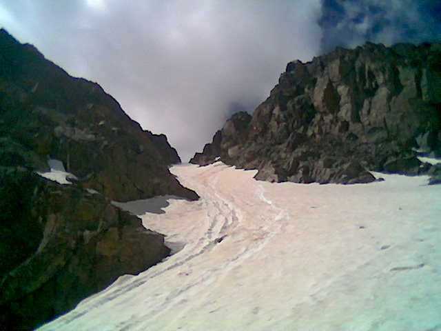
There are a few different ways to go up it but I chose the exciting/challenging method of ascending via the steep couloir. A couloir is a narrow patch of glacier/snow/ice that crawls up a gully on a summit and provides steep access to its top.
Here's the route outlined in red:
There were two tricky parts to getting there. The first part was that there is still a LOT of snow on the mountain this time of year (my hike was on June 30th). This means that periodically the trail is buried beneath a snow drift perhaps four feet deep and 50 feet across. You have to either march over it, sinking up to your knees or more at times, or try and go around, and then hope you can find the trail again.
I didn't know this going up but from the log on the the summit I was something like only the 9th person to climb to the top so far this year. This means that there we'ren't a lot of other footprints through the snow for me to go by. However, the previous few climbers, all of who had been there just a day or two before, had left some footprints I was able to use as rough guide.
The other tricky bit was that while the rock was ok, to cross the boulder field was difficult because it was all very unstable and wobbly. However, I had trekking poles which made things a lot easier.
This is where I diverged from the main trail to attempt the couloir:

Walking across the snow mass:

Begining the ascent:

On the glacier:

Up the couloir
About 3/4 the way up I started to loose a crampon, but I was able to stop and tie it back on. This meant having to sit down in the snow and getting wet but it was better than crossing over to the rock with only one good shoe. Also, the other problem was that by this time the "water resistant" part of my hiking boots was becomming very clearly differentiated from the "water proof" character of boots I do not own. My feet were very wet and starting to get cold to the point where I was nervous and quite uncomfortable. Interestingly enough at the same time the light was blinding (good thing I had sunglasses and a hat) and I got a pretty bad sunburn on the part of my face that wasn't covered.
Welcome to Colorful Colorado, where you can get sunburn and frostbite simultaneously.
So I got to this small rocky outcrop and changed into a fresh pair of wool socks. Always go hiking with extra wool socks. However, I knew that these two would get wet and uncomfortable on the way down. So I cut a very small hole in the tops of both of my wet socks and tied them to the back of my pack so they would dry in the sun. On the way down, after I crossed back over the creek, I put back on these socks, which were now dry, and that trick definately saved me from what would have been some pretty bad blisters.
Also! Mercy, who gave birth to me, gave me some very nice toe warmer things last winter. I had brought one along and put it in the boot of the foot that was getting cold. That also helped. Moms rock.
Finally the couloir ended. About the time I had to change socks I decided this thing was just way too steep and slow, but it would have taken longer to go back than to go forward, and the rock on either side was too steep to switch to rock.
The last few hundred feet to the summit were all these large, table sized boulders that were fun to scramble over, though I had to stop a few times as the thin air was getting to me.
Finally though I made it to the top and sat down to rest for a minute. I think it was about 1pm or so.
The views were great, surrounded by different ranges.

Then I walked down the easier way

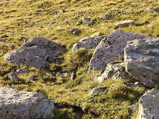
There were a lot of marmots and parmigons. I didn't even see the parmigons until I heard one cluck and then I saw it. They are very well camoflauged to their environment.
Can you see the bird in the center of this picture?
Finally after what seemed like hours of very difficult hiking (I don't think I brought along enough food and my energy level was kind of dropping off) I made it back to the trailhead just before a storm came in. I munched on some hotel pain au chocolate and then collapsed into a sleep for two hours. Then I woke up and hurried off to leadville to for microbrew and food at a restaurant that used to be a saloon where Doc Holiday once shot someone. That night I slept in the car on a nice quiet street in leadville and in the morning I fished early down the arkansas. I didn't have much luck with flies but I got a nice 14 inch and 10 inch brown off a spinner, even though using spinners is kind of like heresy around here.
I finally found the best fishing spot ever but then it was time to head back up 285 to Denver. There was a wreck just east of Bailey which took a while to clear because helicopters landed on the highway to evacuate people.
Then I got to work, where it was dead, and hung around for an hour or two and then got cut. Great!
In other news I started a denver hiking club called Denver Mountaineering. It's basically an email list where people can find rides/climbing partners for excursions. Everyone on it is cool, if you're interested in it let me know.


No comments:
Post a Comment